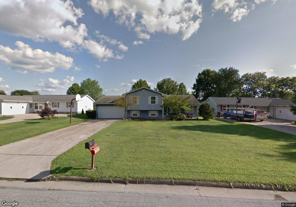
179 Carter Cir Youngstown, OH 44512
Estimated Value: $189,000 - $222,000
3
Beds
2
Baths
1,560
Sq Ft
$132/Sq Ft
Est. Value
About This Home
This home is located at 179 Carter Cir, Youngstown, OH 44512 and is currently estimated at $205,313, approximately $131 per square foot. 179 Carter Cir is a home located in Mahoning County with nearby schools including Stadium Drive Elementary School, Boardman Center Middle School, and Boardman High School.
Ownership History
Date
Name
Owned For
Owner Type
Purchase Details
Closed on
Sep 26, 1995
Sold by
Krasovec David J
Bought by
Haddle Earl M and Haddle Judy L
Current Estimated Value
Home Financials for this Owner
Home Financials are based on the most recent Mortgage that was taken out on this home.
Original Mortgage
$63,000
Interest Rate
7.78%
Mortgage Type
New Conventional
Purchase Details
Closed on
Nov 29, 1990
Bought by
Krasovec David J and Krasovec Kerry
Create a Home Valuation Report for This Property
The Home Valuation Report is an in-depth analysis detailing your home's value as well as a comparison with similar homes in the area
Home Values in the Area
Average Home Value in this Area
Purchase History
| Date | Buyer | Sale Price | Title Company |
|---|---|---|---|
| Haddle Earl M | $98,000 | -- | |
| Krasovec David J | $81,000 | -- |
Source: Public Records
Mortgage History
| Date | Status | Borrower | Loan Amount |
|---|---|---|---|
| Closed | Haddle Earl M | $63,000 |
Source: Public Records
Tax History Compared to Growth
Tax History
| Year | Tax Paid | Tax Assessment Tax Assessment Total Assessment is a certain percentage of the fair market value that is determined by local assessors to be the total taxable value of land and additions on the property. | Land | Improvement |
|---|---|---|---|---|
| 2024 | $2,335 | $54,970 | $9,790 | $45,180 |
| 2023 | $2,336 | $54,970 | $9,790 | $45,180 |
| 2022 | $2,398 | $44,770 | $9,790 | $34,980 |
| 2021 | $2,399 | $44,770 | $9,790 | $34,980 |
| 2020 | $2,412 | $44,770 | $9,790 | $34,980 |
| 2019 | $2,695 | $35,530 | $7,770 | $27,760 |
| 2018 | $2,329 | $35,530 | $7,770 | $27,760 |
| 2017 | $2,288 | $35,530 | $7,770 | $27,760 |
| 2016 | $1,996 | $30,620 | $7,770 | $22,850 |
| 2015 | $1,957 | $30,620 | $7,770 | $22,850 |
| 2014 | $1,963 | $30,620 | $7,770 | $22,850 |
| 2013 | $1,938 | $30,620 | $7,770 | $22,850 |
Source: Public Records
Map
Nearby Homes
- 8502 Glenwood Ave
- 153 Creston Dr
- 74 Carter Cir
- 470 Garver Dr
- 9144 Sharrott Rd
- 0 W Western Reserve Rd Unit 5146459
- 9264 Sharrott Rd Unit 1004
- 9264 Sharrott Rd Unit 1001
- 9264 Sharrott Rd Unit 104
- 9264 Sharrott Rd Unit 1002
- Rosewood Plan at Courtyards at Stonegate
- 1555 W Western Reserve Rd
- 8218 Maramont Dr Unit B
- 123 Mayflower Dr
- Lot 43 Berklee Dr
- Lot 36 Berklee Dr
- Lot 44 Berklee Dr
- Lot 37 Berklee Dr
- 134 Mayflower Dr
- 150 Cedars Dr
- 175 Carter Cir
- 178 Runnemede Dr
- 171 Carter Cir
- 176 Runnemede Dr
- 187 Carter Cir
- 178 Carter Cir
- 182 Carter Cir
- 182 Runnemede Dr
- 174 Carter Cir
- 172 Runnemede Dr
- 8527 Glenwood Ave
- 167 Carter Cir
- 186 Carter Cir
- 170 Carter Cir
- 8519 Glenwood Ave
- 168 Runnemede Dr
- 186 Runnemede Dr
- 8511 Glenwood Ave
- 190 Carter Cir
- 166 Carter Cir