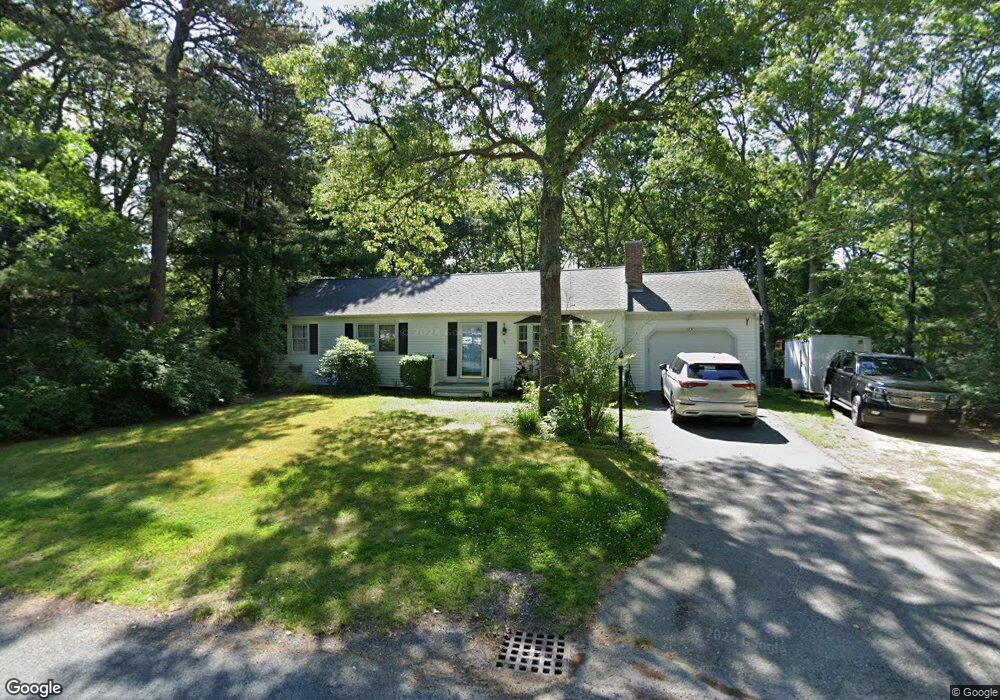
179 Cedric Rd Centerville, MA 02632
Centerville NeighborhoodEstimated Value: $574,000 - $621,000
3
Beds
2
Baths
1,248
Sq Ft
$473/Sq Ft
Est. Value
About This Home
This home is located at 179 Cedric Rd, Centerville, MA 02632 and is currently estimated at $589,828, approximately $472 per square foot. 179 Cedric Rd is a home located in Barnstable County with nearby schools including West Villages Elementary School, Barnstable United Elementary School, and Barnstable Intermediate School.
Ownership History
Date
Name
Owned For
Owner Type
Purchase Details
Closed on
Jun 30, 2020
Sold by
Gingras Diane R
Bought by
Daniels Rhonda
Current Estimated Value
Home Financials for this Owner
Home Financials are based on the most recent Mortgage that was taken out on this home.
Original Mortgage
$367,500
Outstanding Balance
$322,867
Interest Rate
3.2%
Mortgage Type
New Conventional
Estimated Equity
$266,961
Purchase Details
Closed on
May 21, 2001
Sold by
Rice David H
Bought by
Gingras Diane R
Home Financials for this Owner
Home Financials are based on the most recent Mortgage that was taken out on this home.
Original Mortgage
$114,100
Interest Rate
7.03%
Mortgage Type
Purchase Money Mortgage
Purchase Details
Closed on
Jun 10, 1991
Sold by
Magdalene D Donovan
Bought by
Rice David H
Home Financials for this Owner
Home Financials are based on the most recent Mortgage that was taken out on this home.
Original Mortgage
$90,000
Interest Rate
9.42%
Mortgage Type
Purchase Money Mortgage
Create a Home Valuation Report for This Property
The Home Valuation Report is an in-depth analysis detailing your home's value as well as a comparison with similar homes in the area
Home Values in the Area
Average Home Value in this Area
Purchase History
| Date | Buyer | Sale Price | Title Company |
|---|---|---|---|
| Daniels Rhonda | $375,000 | None Available | |
| Gingras Diane R | $163,000 | -- | |
| Rice David H | $100,000 | -- |
Source: Public Records
Mortgage History
| Date | Status | Borrower | Loan Amount |
|---|---|---|---|
| Open | Daniels Rhonda | $367,500 | |
| Previous Owner | Rice David H | $140,982 | |
| Previous Owner | Rice David H | $114,100 | |
| Previous Owner | Rice David H | $90,000 |
Source: Public Records
Tax History
| Year | Tax Paid | Tax Assessment Tax Assessment Total Assessment is a certain percentage of the fair market value that is determined by local assessors to be the total taxable value of land and additions on the property. | Land | Improvement |
|---|---|---|---|---|
| 2025 | $3,953 | $488,600 | $156,800 | $331,800 |
| 2024 | $3,793 | $485,700 | $156,800 | $328,900 |
| 2023 | $3,555 | $426,300 | $142,600 | $283,700 |
| 2022 | $3,386 | $351,200 | $105,600 | $245,600 |
| 2021 | $3,234 | $308,300 | $105,600 | $202,700 |
| 2020 | $3,325 | $303,400 | $105,600 | $197,800 |
| 2019 | $3,156 | $279,800 | $105,600 | $174,200 |
| 2018 | $2,903 | $258,700 | $111,200 | $147,500 |
| 2017 | $2,692 | $250,200 | $111,200 | $139,000 |
| 2016 | $2,739 | $251,300 | $112,300 | $139,000 |
| 2015 | $2,641 | $243,400 | $110,000 | $133,400 |
Source: Public Records
Map
Nearby Homes
- 169 Cedric Rd
- 87 Foxglove Rd
- 352 Nye Rd
- 315 Prince Hinckley Rd
- 900 Old Stage Rd
- 296 Buckskin Path
- 7 Ebenezer
- 585 Old Falmouth Rd
- 80 Branch Terrace
- 74 Saddler Ln
- 324 Patriot Way
- 29 Appaloosa Way
- 51 Larch Ln
- 73 Tern Ln
- 66 Tern Ln
- 200 Lumbert Mill Rd
- 1309 Shootflying Hill Rd
- 1309 Shootflying Hill Rd
- 97 Yacht Club Rd
- 82 Yacht Club Rd
Your Personal Tour Guide
Ask me questions while you tour the home.