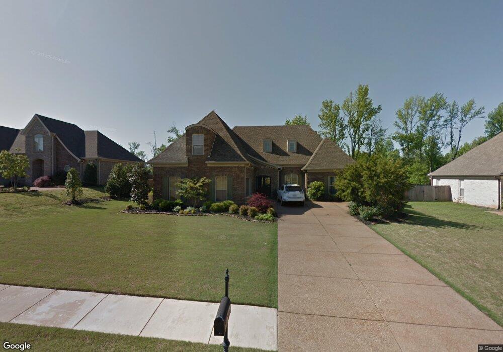
179 Doe Creek Trail N Hernando, MS 38632
Estimated Value: $368,000 - $395,691
4
Beds
3
Baths
2,700
Sq Ft
$140/Sq Ft
Est. Value
About This Home
This home is located at 179 Doe Creek Trail N, Hernando, MS 38632 and is currently estimated at $377,923, approximately $139 per square foot. 179 Doe Creek Trail N is a home located in DeSoto County with nearby schools including Oak Grove Central Elementary School, Hernando Elementary School, and Hernando Hills Elementary.
Ownership History
Date
Name
Owned For
Owner Type
Purchase Details
Closed on
Jun 4, 2019
Sold by
Venture Signature Homes Llc
Bought by
Moore David P and Moore Carolyn C
Current Estimated Value
Purchase Details
Closed on
Feb 27, 2008
Sold by
First Security Bank
Bought by
Moore David P and Moore Carolyn C
Home Financials for this Owner
Home Financials are based on the most recent Mortgage that was taken out on this home.
Original Mortgage
$210,900
Interest Rate
5.46%
Mortgage Type
Seller Take Back
Create a Home Valuation Report for This Property
The Home Valuation Report is an in-depth analysis detailing your home's value as well as a comparison with similar homes in the area
Home Values in the Area
Average Home Value in this Area
Purchase History
| Date | Buyer | Sale Price | Title Company |
|---|---|---|---|
| Moore David P | -- | None Available | |
| Moore David P | -- | First National Financial Tit |
Source: Public Records
Mortgage History
| Date | Status | Borrower | Loan Amount |
|---|---|---|---|
| Previous Owner | Moore David P | $210,900 |
Source: Public Records
Tax History Compared to Growth
Tax History
| Year | Tax Paid | Tax Assessment Tax Assessment Total Assessment is a certain percentage of the fair market value that is determined by local assessors to be the total taxable value of land and additions on the property. | Land | Improvement |
|---|---|---|---|---|
| 2024 | $1,690 | $19,682 | $3,500 | $16,182 |
| 2023 | $1,690 | $19,682 | $0 | $0 |
| 2022 | $1,690 | $19,682 | $3,500 | $16,182 |
| 2021 | $1,690 | $19,682 | $3,500 | $16,182 |
| 2020 | $1,690 | $19,682 | $0 | $0 |
| 2019 | $1,690 | $19,682 | $3,500 | $16,182 |
| 2017 | $2,389 | $35,064 | $19,282 | $15,782 |
| 2016 | $2,276 | $19,282 | $3,500 | $15,782 |
| 2015 | $2,576 | $35,064 | $19,282 | $15,782 |
| 2014 | $2,215 | $19,282 | $0 | $0 |
| 2013 | $2,101 | $19,282 | $0 | $0 |
Source: Public Records
Map
Nearby Homes
- 617 Doe Creek Trail N
- 430 Natchez Loop
- 5157 U S 51
- 5153 U S 51
- 5163 U S 51
- 5135 U S 51
- 5147 U S 51
- 5167 U S 51
- 5093 U S 51
- 0 S Old Hwy 51 Unit 4105246
- 566 Shadow View Dr E
- 994 Deer Creek Dr
- 732 Shadow View Dr
- 1064 Tara Dr
- 470 Beacon Hill Dr
- 208 Elkwood Ln
- 1094 Peggy Cove
- 1265 U S 51
- 509 Howell Way
- 0 Highway 51 N
- 161 Doe Creek Trail N
- 199 Doe Creek Trail N
- 198 Shady Lane Cove W
- 160 Shady Lane Cove
- 160 Shady Lane Cove W
- 215 Doe Creek Trail N
- 653 Fallbrook Cove
- 145 Doe Creek Trail N
- 653 Fall Brook Cove
- 216 Shady Lane Cove W
- 144 Shady Lane Cove W
- 112 Shady Lane Cove E
- 658 Doe Creek Trail N
- 235 Doe Creek Trail N
- 220 Shady Lane Cove W
- 235 Doe Creek Trail N
- 650 Fallbrook Cove
- 44 Doe Creek Trail
- 635 Fall Brook Cove
- 169 Shady Lane Cove W