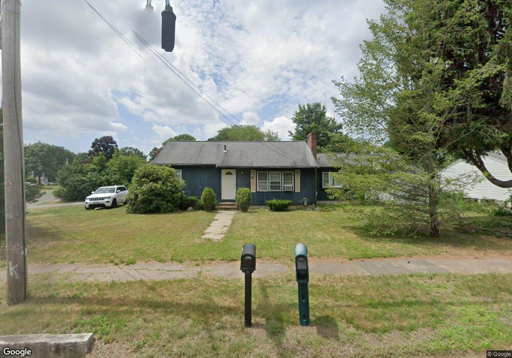
179 East St Foxboro, MA 02035
Estimated Value: $500,378 - $625,000
3
Beds
2
Baths
1,136
Sq Ft
$487/Sq Ft
Est. Value
About This Home
This home is located at 179 East St, Foxboro, MA 02035 and is currently estimated at $553,595, approximately $487 per square foot. 179 East St is a home located in Norfolk County with nearby schools including Foxborough High School, St Mary's Catholic School, and Hands-On-Montessori School.
Ownership History
Date
Name
Owned For
Owner Type
Purchase Details
Closed on
Aug 4, 2003
Sold by
Donovan Timothy E and Donovan Lorraine T
Bought by
Martignetti Massimo P and Martignetti Nancy M
Current Estimated Value
Home Financials for this Owner
Home Financials are based on the most recent Mortgage that was taken out on this home.
Original Mortgage
$305,900
Outstanding Balance
$131,366
Interest Rate
5.28%
Mortgage Type
Purchase Money Mortgage
Estimated Equity
$422,229
Create a Home Valuation Report for This Property
The Home Valuation Report is an in-depth analysis detailing your home's value as well as a comparison with similar homes in the area
Home Values in the Area
Average Home Value in this Area
Purchase History
| Date | Buyer | Sale Price | Title Company |
|---|---|---|---|
| Martignetti Massimo P | $322,000 | -- |
Source: Public Records
Mortgage History
| Date | Status | Borrower | Loan Amount |
|---|---|---|---|
| Open | Martignetti Massimo P | $305,900 | |
| Previous Owner | Martignetti Massimo P | $6,638 |
Source: Public Records
Tax History Compared to Growth
Tax History
| Year | Tax Paid | Tax Assessment Tax Assessment Total Assessment is a certain percentage of the fair market value that is determined by local assessors to be the total taxable value of land and additions on the property. | Land | Improvement |
|---|---|---|---|---|
| 2025 | $5,049 | $381,900 | $187,200 | $194,700 |
| 2024 | $5,074 | $375,600 | $201,800 | $173,800 |
| 2023 | $4,708 | $331,300 | $192,200 | $139,100 |
| 2022 | $4,569 | $314,700 | $172,300 | $142,400 |
| 2021 | $4,457 | $302,400 | $163,700 | $138,700 |
| 2020 | $4,241 | $291,100 | $163,700 | $127,400 |
| 2019 | $4,210 | $286,400 | $164,100 | $122,300 |
| 2018 | $3,981 | $273,200 | $155,900 | $117,300 |
| 2017 | $3,921 | $260,700 | $153,400 | $107,300 |
| 2016 | $3,877 | $261,600 | $147,600 | $114,000 |
| 2015 | $3,444 | $226,700 | $110,100 | $116,600 |
| 2014 | $3,437 | $229,300 | $110,100 | $119,200 |
Source: Public Records
Map
Nearby Homes
- 1 Revere Dr
- 7 Revere Dr
- 12 Community Way
- 261 East St
- 35 Independence Dr Unit 35
- 9 Independence Dr Unit 9
- 67 Morse St
- 5 Lauren Ln
- 132 Cannon Forge Dr
- 170 Cannon Forge Dr
- 2 Red Fox Run
- 25 Winter St
- 55-57 Pine Needle Ln
- 260 Massapoag Ave
- 3 Cushing Ln
- 619 N Main St
- 89 Oak St
- 218 Massapoag Ave
- 3 Nicole Rd
- 3 Wampanoag Rd