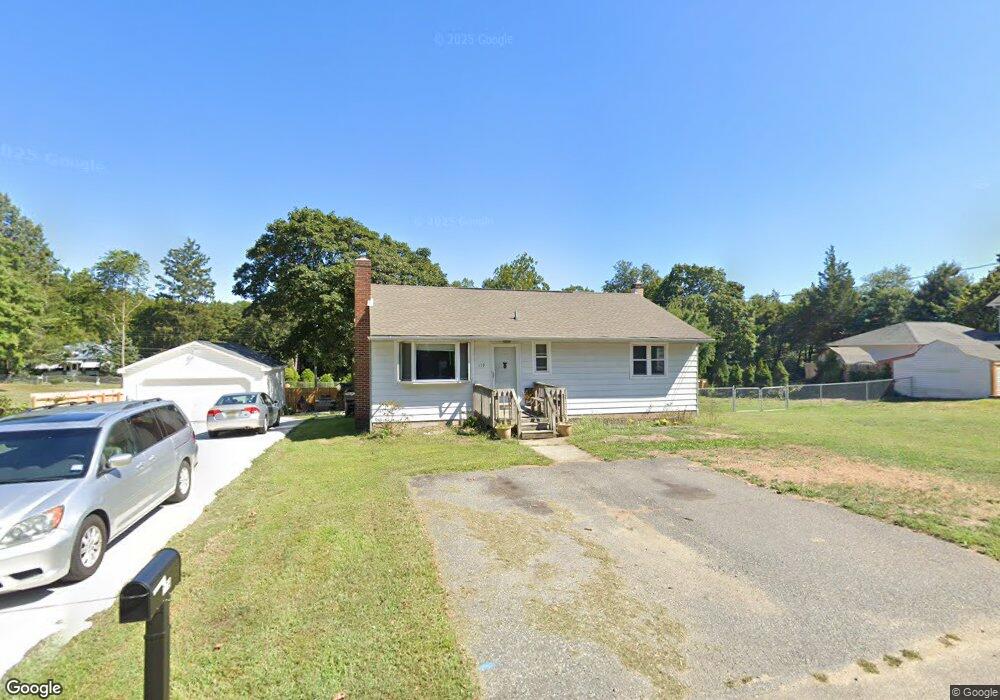
179 Linden Ave Mantua, NJ 08051
Mantua Township NeighborhoodEstimated Value: $260,000 - $307,195
--
Bed
--
Bath
1,064
Sq Ft
$270/Sq Ft
Est. Value
About This Home
This home is located at 179 Linden Ave, Mantua, NJ 08051 and is currently estimated at $286,799, approximately $269 per square foot. 179 Linden Ave is a home located in Gloucester County with nearby schools including J. Mason Tomlin Elementary School, Centre City School, and Clearview Regional Middle School.
Ownership History
Date
Name
Owned For
Owner Type
Purchase Details
Closed on
Mar 28, 2003
Sold by
Rink Walter H
Bought by
Eastlack Christopher
Current Estimated Value
Home Financials for this Owner
Home Financials are based on the most recent Mortgage that was taken out on this home.
Original Mortgage
$125,400
Outstanding Balance
$53,871
Interest Rate
5.75%
Mortgage Type
Purchase Money Mortgage
Estimated Equity
$232,928
Create a Home Valuation Report for This Property
The Home Valuation Report is an in-depth analysis detailing your home's value as well as a comparison with similar homes in the area
Home Values in the Area
Average Home Value in this Area
Purchase History
| Date | Buyer | Sale Price | Title Company |
|---|---|---|---|
| Eastlack Christopher | $132,000 | -- |
Source: Public Records
Mortgage History
| Date | Status | Borrower | Loan Amount |
|---|---|---|---|
| Open | Eastlack Christopher | $125,400 |
Source: Public Records
Tax History Compared to Growth
Tax History
| Year | Tax Paid | Tax Assessment Tax Assessment Total Assessment is a certain percentage of the fair market value that is determined by local assessors to be the total taxable value of land and additions on the property. | Land | Improvement |
|---|---|---|---|---|
| 2025 | $7,071 | $291,200 | $61,100 | $230,100 |
| 2024 | $6,997 | $274,600 | $61,100 | $213,500 |
| 2023 | $6,997 | $274,600 | $61,100 | $213,500 |
| 2022 | $5,268 | $150,600 | $51,100 | $99,500 |
| 2021 | $5,307 | $150,600 | $51,100 | $99,500 |
| 2020 | $5,265 | $150,600 | $51,100 | $99,500 |
| 2019 | $5,176 | $150,600 | $51,100 | $99,500 |
| 2018 | $5,102 | $150,600 | $51,100 | $99,500 |
| 2017 | $5,026 | $150,600 | $51,100 | $99,500 |
| 2016 | $4,711 | $142,800 | $51,100 | $91,700 |
| 2015 | $4,595 | $142,800 | $51,100 | $91,700 |
| 2014 | $4,441 | $142,800 | $51,100 | $91,700 |
Source: Public Records
Map
Nearby Homes
- 1195 Tristram Cir Unit 5
- 1137 Tristram Cir Unit 1137
- 1134 Tristram Cir Unit 4
- 1184 Tristram Cir Unit 4
- 1145 Tristram Cir
- 1230 Tristram Cir Unit 1230
- 12 Brittany St
- 118 Pendragon Way Unit 118
- 1356 Tristram Cir Unit 1356
- 75 Hickory Ave
- 530 Galahad Ct
- 1410 Tristram Cir Unit 1410
- 1415 Tristram Cir Unit 1415
- 8 Barry Dr
- 122 Turner St
- 433 Berkley Rd
- 22 Marathon Dr
- 712 Sunflower Way Unit 712
- 325 Bridgeton Pike
- 811 Sunflower Way
- 195 Linden Ave
- 194 W Elm Ave
- 186 W Elm Ave
- 320 Berkley Rd
- 176 Linden Ave
- 181 Ash Ave
- 178 W Elm Ave
- 197 Ash Ave
- 290 Berkley Rd
- 1110 Tristram Cir Unit 1110
- 1111 Tristram Cir Unit 1111
- 170 W Elm Ave
- 1122 Tristram Cir Unit 2
- 177 Ash Ave
- 177 W Elm Ave
- 1121 Tristram Cir Unit 1
- 1117 Tristram Cir Unit 1117
- 160 Linden Ave
- 1112 Tristram Cir Unit 1112
- 1123 Tristram Cir Unit 3