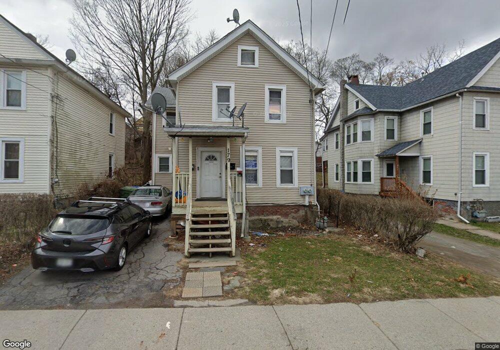
179 Linden Ave Middletown, NY 10940
Estimated Value: $190,000 - $338,000
4
Beds
2
Baths
1,464
Sq Ft
$204/Sq Ft
Est. Value
About This Home
This home is located at 179 Linden Ave, Middletown, NY 10940 and is currently estimated at $299,252, approximately $204 per square foot. 179 Linden Ave is a home located in Orange County with nearby schools including Presidential Park Elementary School, Middletown Twin Towers Middle School, and Monhagen Middle School.
Ownership History
Date
Name
Owned For
Owner Type
Purchase Details
Closed on
Dec 30, 2011
Sold by
Walden Savings Bank
Bought by
Ferrer Clotilde
Current Estimated Value
Purchase Details
Closed on
Aug 5, 2011
Sold by
Kelson Todd
Bought by
Walden Savings Bank
Purchase Details
Closed on
Feb 17, 2006
Sold by
Lewis John
Bought by
Bileez Enterprise Llc
Purchase Details
Closed on
Feb 21, 2003
Sold by
Wong Helga
Bought by
Lewis John L
Create a Home Valuation Report for This Property
The Home Valuation Report is an in-depth analysis detailing your home's value as well as a comparison with similar homes in the area
Home Values in the Area
Average Home Value in this Area
Purchase History
| Date | Buyer | Sale Price | Title Company |
|---|---|---|---|
| Ferrer Clotilde | $30,000 | Thomas Egan | |
| Walden Savings Bank | $65,000 | Johnson & Foley Pc | |
| Bileez Enterprise Llc | -- | Kenneth Johnson | |
| Lewis John L | $60,000 | William O'Keeffe |
Source: Public Records
Tax History Compared to Growth
Tax History
| Year | Tax Paid | Tax Assessment Tax Assessment Total Assessment is a certain percentage of the fair market value that is determined by local assessors to be the total taxable value of land and additions on the property. | Land | Improvement |
|---|---|---|---|---|
| 2024 | $4,365 | $15,900 | $4,300 | $11,600 |
| 2023 | $4,365 | $15,900 | $4,300 | $11,600 |
| 2022 | $4,275 | $15,900 | $4,300 | $11,600 |
| 2021 | $4,498 | $15,900 | $4,300 | $11,600 |
| 2020 | $1,841 | $15,900 | $4,300 | $11,600 |
| 2019 | $1,725 | $15,900 | $4,300 | $11,600 |
| 2018 | $4,271 | $15,900 | $4,300 | $11,600 |
| 2017 | $4,141 | $15,900 | $4,300 | $11,600 |
| 2016 | $4,152 | $15,900 | $4,300 | $11,600 |
| 2015 | -- | $15,900 | $4,300 | $11,600 |
| 2014 | -- | $15,900 | $4,300 | $11,600 |
Source: Public Records
Map
Nearby Homes
- 30 Royce Ave
- 37 Wisner Ave Unit 39
- 143 N Beacon St
- 73 Watkins Ave
- 71 Commonwealth Ave
- 127 Watkins Ave Unit 129
- 92 Linden Ave
- 13 Smith St
- 15 Commonwealth Ave
- 38 Prospect St
- 80 Beattie Ave
- 31 Beattie Ave
- 115 Vincent Dr
- 47 Prince St
- 65 Sycamore Dr
- 3 Parkview Dr
- 55 Prince St
- 26 Sycamore Dr
- 89 Sycamore Dr
- 1 Polly Kay Dr
- 181 Linden Ave
- 177 1/2 Linden Ave
- 177 Linden Ave
- 175 Linden Ave
- 185 Linden Ave
- 104 N Beacon St
- 110 N Beacon St
- 182 Linden Ave
- 173 Linden Ave
- 102 N Beacon St
- 112 N Beacon St
- 180 Linden Ave
- 185 1/2 Linden Ave
- 169 Linden Ave
- 100 N Beacon St
- 178 Linden Ave
- 184 Linden Ave Unit 186
- 176 Linden Ave
- 187 Linden Ave
- 171 Linden Ave