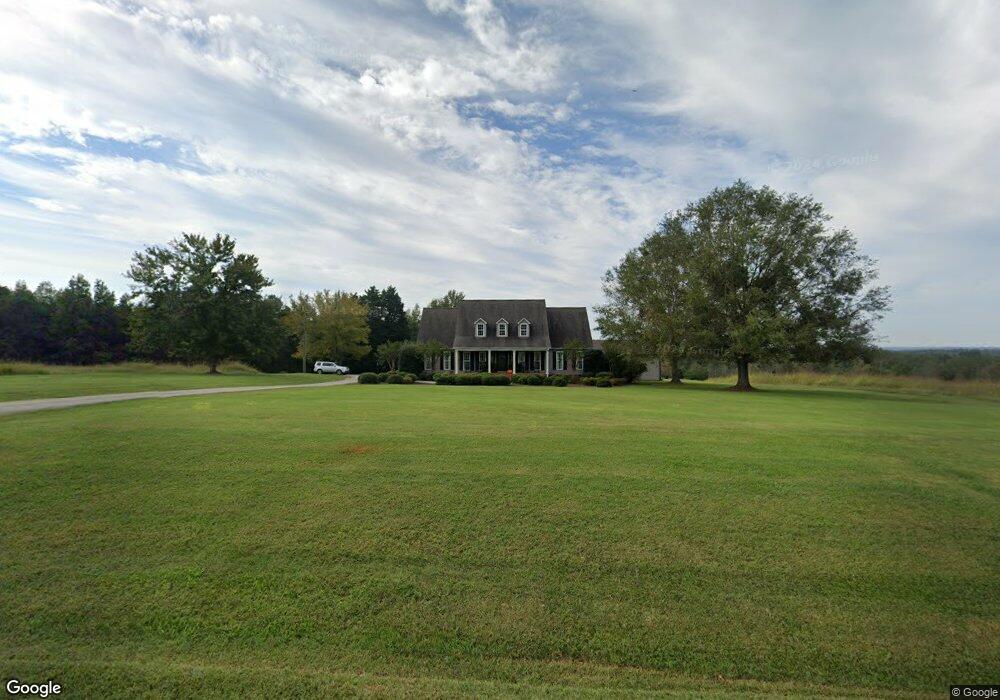
179 Newman Rd Roebuck, SC 29376
Estimated Value: $557,752 - $649,000
3
Beds
3
Baths
2,726
Sq Ft
$217/Sq Ft
Est. Value
About This Home
This home is located at 179 Newman Rd, Roebuck, SC 29376 and is currently estimated at $591,917, approximately $217 per square foot. 179 Newman Rd is a home located in Spartanburg County with nearby schools including Dorman High School Freshman Campus and Dorman High School.
Ownership History
Date
Name
Owned For
Owner Type
Purchase Details
Closed on
Jul 25, 2025
Sold by
Plexico Brian P and Plexico Kimberly T
Bought by
Plexico Brian P and Plexico Kimberly Turner
Current Estimated Value
Home Financials for this Owner
Home Financials are based on the most recent Mortgage that was taken out on this home.
Original Mortgage
$406,500
Outstanding Balance
$405,806
Interest Rate
6.81%
Mortgage Type
New Conventional
Estimated Equity
$186,111
Create a Home Valuation Report for This Property
The Home Valuation Report is an in-depth analysis detailing your home's value as well as a comparison with similar homes in the area
Purchase History
| Date | Buyer | Sale Price | Title Company |
|---|---|---|---|
| Plexico Brian P | -- | None Listed On Document |
Source: Public Records
Mortgage History
| Date | Status | Borrower | Loan Amount |
|---|---|---|---|
| Open | Plexico Brian P | $406,500 |
Source: Public Records
Tax History
| Year | Tax Paid | Tax Assessment Tax Assessment Total Assessment is a certain percentage of the fair market value that is determined by local assessors to be the total taxable value of land and additions on the property. | Land | Improvement |
|---|---|---|---|---|
| 2022 | $1,854 | $11,118 | $278 | $10,840 |
| 2021 | $1,873 | $11,118 | $278 | $10,840 |
| 2020 | $1,827 | $11,118 | $278 | $10,840 |
| 2019 | $1,827 | $11,118 | $278 | $10,840 |
| 2018 | $1,835 | $11,118 | $278 | $10,840 |
| 2017 | $1,269 | $7,706 | $226 | $7,480 |
| 2016 | $1,268 | $7,706 | $226 | $7,480 |
| 2015 | $1,264 | $7,706 | $226 | $7,480 |
| 2014 | $1,220 | $7,706 | $226 | $7,480 |
Source: Public Records
Map
Nearby Homes
- 0 Cavalier Conection Dr Unit 298383
- 603 Charles Moore Ct
- Harrison Rd
- Harrison Rd
- 350 W River Grove Cir
- 160 Blake Garrison Dr
- 359 W River Grove Cir
- 245 Thorncrest Dr
- 305 Lawtonwood Ln
- 335 Amy Marie Ln
- 339 Sara Ann Ln
- 149 Davy Crockett Trail
- 310 Templeton Dr
- 100 Caroline Dr
- 0 Cavalier Connection Way Unit 1549706
- 811 S Edisto River Dr
- 115 Otts Shoals Rd
- 212 Reedy River Ct
- 0 U S 221 North Hwy
- 408 Congaree Rd
- 299 Newman Rd
- 126 Miller Rd
- 119 Miller Rd
- 130 Miller Rd
- 140 Miller Rd
- 370 Newman Dr
- 115 Miller Rd
- 390 Newman Rd
- 106 Miller Rd
- 630 Harrison Grove Rd
- 150 Miller Rd
- 141 Miller Rd
- 708 Harrison Grove Rd
- 420 Harrison Grove Rd
- 0 Miller Rd
- 650 Harrison Grove Rd
- 159 Miller Rd
- 418 Harrison Grove Rd
- 700 Harrison Grove Rd
- 712 Harrison Grove Rd
Your Personal Tour Guide
Ask me questions while you tour the home.