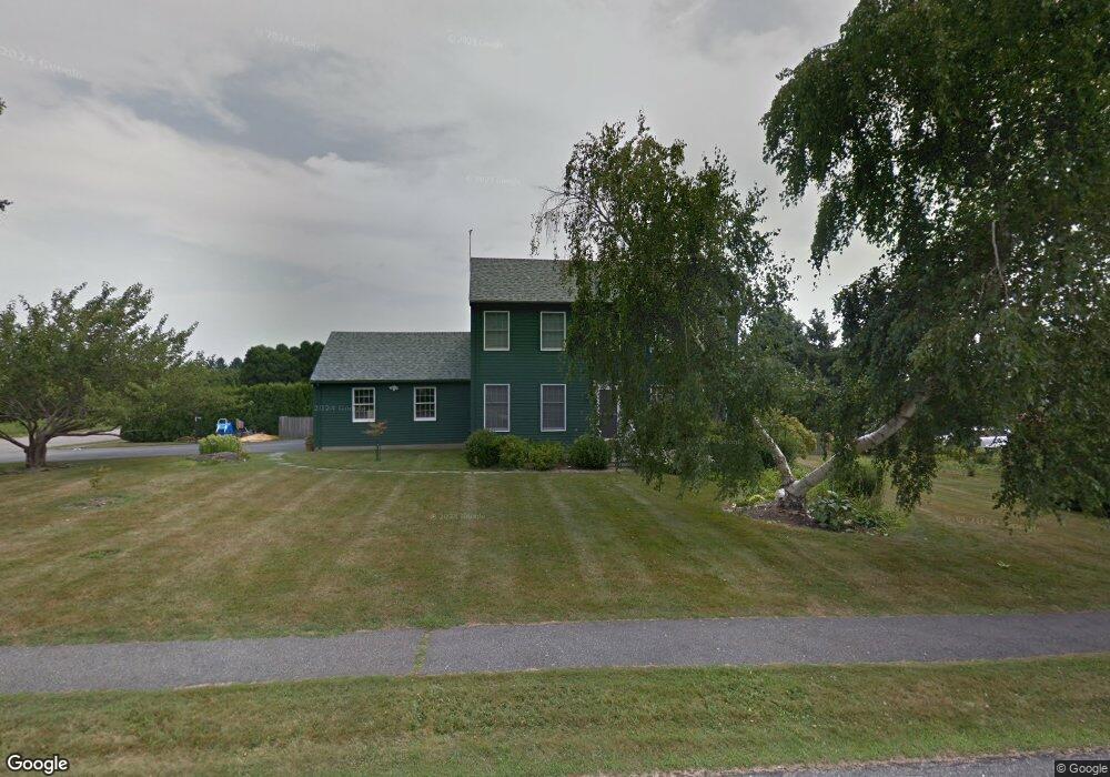
179 River Run Middletown, RI 02842
Estimated Value: $669,000 - $1,266,000
4
Beds
3
Baths
2,708
Sq Ft
$349/Sq Ft
Est. Value
About This Home
This home is located at 179 River Run, Middletown, RI 02842 and is currently estimated at $943,891, approximately $348 per square foot. 179 River Run is a home located in Newport County with nearby schools including Middletown High School, St Michael's Country Day School, and St George's School.
Ownership History
Date
Name
Owned For
Owner Type
Purchase Details
Closed on
Nov 18, 2024
Sold by
Stevens Mary F
Bought by
Winthrop J P J and Winthrop Alexandra
Current Estimated Value
Purchase Details
Closed on
Nov 8, 2010
Sold by
Mchenry Donald A and Mchenry Donna M
Bought by
Stevens William B and Stevens Mary F
Create a Home Valuation Report for This Property
The Home Valuation Report is an in-depth analysis detailing your home's value as well as a comparison with similar homes in the area
Home Values in the Area
Average Home Value in this Area
Purchase History
| Date | Buyer | Sale Price | Title Company |
|---|---|---|---|
| Winthrop J P J | $600,000 | None Available | |
| Winthrop J P J | $600,000 | None Available | |
| Stevens William B | $500,000 | -- | |
| Stevens William B | $500,000 | -- |
Source: Public Records
Mortgage History
| Date | Status | Borrower | Loan Amount |
|---|---|---|---|
| Previous Owner | Stevens William B | $300,000 | |
| Previous Owner | Stevens William B | $250,000 | |
| Previous Owner | Stevens William B | $185,000 |
Source: Public Records
Tax History Compared to Growth
Tax History
| Year | Tax Paid | Tax Assessment Tax Assessment Total Assessment is a certain percentage of the fair market value that is determined by local assessors to be the total taxable value of land and additions on the property. | Land | Improvement |
|---|---|---|---|---|
| 2025 | $9,187 | $779,200 | $467,100 | $312,100 |
| 2024 | $8,774 | $779,200 | $467,100 | $312,100 |
| 2023 | $6,507 | $516,800 | $290,200 | $226,600 |
| 2022 | $6,212 | $516,800 | $290,200 | $226,600 |
| 2021 | $6,212 | $516,800 | $290,200 | $226,600 |
| 2020 | $6,691 | $486,300 | $281,300 | $205,000 |
| 2018 | $6,687 | $486,300 | $281,300 | $205,000 |
| 2016 | $7,048 | $457,100 | $239,700 | $217,400 |
| 2015 | $6,875 | $457,100 | $239,700 | $217,400 |
| 2014 | $7,299 | $454,200 | $209,500 | $244,700 |
| 2013 | $7,135 | $454,200 | $209,500 | $244,700 |
Source: Public Records
Map
Nearby Homes
- 0 Wolcott Ave
- 16 Sachuest Dr
- 0 Saltwood Dr
- 141 Gray Craig Rd
- 118 Wolcott Ave
- 318 Corey Ln
- 980 Green End Ave
- 0 Honeyman Ave
- 310 Corey Ln
- 119 Corey Ln
- 476 Green End Ave
- 162 Center Ave
- 223 Corey Ln
- 65 Seascape Ave
- 84 Allston Ave
- 55 John Clarke Rd Unit 8
- 55 John Clarke Rd Unit 3
- 138 Green End Ave
- 4 James St
- 140 Tuckerman Ave
- 8 Maidford River Rd
- 155 River Run
- 166 River Run
- 6 Maidford River Rd
- 10 Maidford River Rd
- 4 Maidford River Rd
- 133 River Run
- 12 Maidford River Rd
- 87 Prospect Ave
- 79 Prospect Ave
- 124 River Run
- 7 Maidford River Rd
- 129 River Run
- 5 Maidford River Rd
- 9 Maidford River Rd
- 2 Maidford River Rd
- 113 Prospect Ave
- 0 River Run
- 3 Maidford River Rd
- 119 Prospect Ave