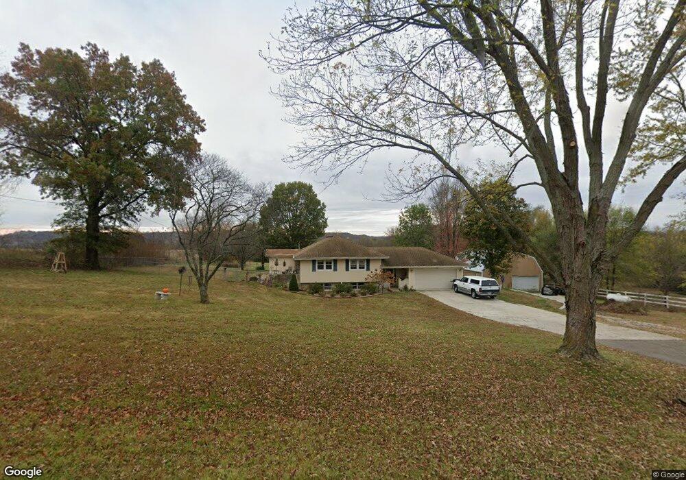
17921 Logan Rd Leavenworth, KS 66048
Estimated Value: $380,404 - $573,000
3
Beds
3
Baths
1,526
Sq Ft
$339/Sq Ft
Est. Value
About This Home
This home is located at 17921 Logan Rd, Leavenworth, KS 66048 and is currently estimated at $516,851, approximately $338 per square foot. 17921 Logan Rd is a home located in Leavenworth County with nearby schools including Pleasant Ridge Elementary School, Pleasant Ridge Middle School, and Pleasant Ridge High School.
Ownership History
Date
Name
Owned For
Owner Type
Purchase Details
Closed on
May 26, 2017
Sold by
Bergman Arvid D and Bergman Barbara J
Bought by
Willis Kenneth M and Willis Violet M
Current Estimated Value
Home Financials for this Owner
Home Financials are based on the most recent Mortgage that was taken out on this home.
Original Mortgage
$100,000
Outstanding Balance
$52,376
Interest Rate
3.97%
Mortgage Type
New Conventional
Estimated Equity
$464,475
Create a Home Valuation Report for This Property
The Home Valuation Report is an in-depth analysis detailing your home's value as well as a comparison with similar homes in the area
Home Values in the Area
Average Home Value in this Area
Purchase History
| Date | Buyer | Sale Price | Title Company |
|---|---|---|---|
| Willis Kenneth M | $125,000 | Mccaffree-Short Title Co Inc |
Source: Public Records
Mortgage History
| Date | Status | Borrower | Loan Amount |
|---|---|---|---|
| Open | Willis Kenneth M | $100,000 |
Source: Public Records
Tax History Compared to Growth
Tax History
| Year | Tax Paid | Tax Assessment Tax Assessment Total Assessment is a certain percentage of the fair market value that is determined by local assessors to be the total taxable value of land and additions on the property. | Land | Improvement |
|---|---|---|---|---|
| 2025 | $3,780 | $39,224 | $4,247 | $34,977 |
| 2024 | $3,674 | $37,800 | $3,078 | $34,722 |
| 2023 | $3,674 | $36,695 | $3,075 | $33,620 |
| 2022 | $3,318 | $33,028 | $3,331 | $29,697 |
| 2021 | $3,200 | $30,993 | $3,325 | $27,668 |
| 2020 | $3,042 | $29,337 | $3,316 | $26,021 |
| 2019 | $2,982 | $28,687 | $2,914 | $25,773 |
| 2018 | $3,042 | $29,298 | $2,829 | $26,469 |
| 2017 | $2,425 | $23,348 | $2,799 | $20,549 |
| 2016 | $2,364 | $22,736 | $3,426 | $19,310 |
| 2015 | $2,298 | $21,971 | $2,443 | $19,528 |
| 2014 | $2,294 | $22,039 | $2,399 | $19,640 |
Source: Public Records
Map
Nearby Homes
- 18750 Chmidling Dr
- 33931 167th St
- 34903 195th St
- 16321 Hildebrandt Rd
- 20513 Lowemont Rd
- 19115 Missouri 45
- 16425 Fort Riley Rd
- 908 Washington St
- 17051 Mount Olivet Rd
- 0 P Hwy Unit HMS2578569
- 27130 Webster Ct
- 000000 195th St
- 0 195th St
- 32378 215 St
- 19100 Library Dr
- 19101 Library Dr
- 20119 Cider Ct
- 0 Salem Rd
- 0 Middle Rd
- 2017 Metropolitan Ave