
Seller's Agent in 2025
Krista Kirkwood
Coldwell Banker Realty
(614) 330-1364
2 in this area
41 Total Sales
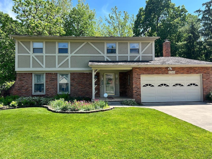
Welcome to this well-kept, second-owner home offering four spacious bedrooms and 2.5 bathrooms. Lovingly maintained throughout, this inviting property features a beautiful three-season sunroom with removable windows—perfect for enjoying the outdoors year-round. Step outside to a multi-level deck that leads to a screened-in gazebo, ideal for entertaining or unwinding in total privacy. The backyard is truly a showstopper—wooded and serene with the picturesque Knoll Run Creek flowing through. You'll also find a cozy patio and fire pit area, perfect for relaxed evenings and gatherings with friends. The laundry area was thoughtfully relocated to the upper level approximately 15 years ago, and the washer and dryer will stay with the home. The walk-out basement offers ample space and is ready for you to finish and customize to your needs. Don't miss the opportunity to own this peaceful retreat that blends comfort, charm, and outdoor beauty—all in one perfect package.
Professional photos coming soon.
Last Agent to Sell the Property
Coldwell Banker Realty License #2021000588 Listed on: 05/24/2025
| Date | Type | Sale Price | Title Company |
|---|---|---|---|
| Deed | $404,000 | Crown Search Box | |
| Interfamily Deed Transfer | -- | Attorney | |
| Interfamily Deed Transfer | -- | -- | |
| Deed | $99,000 | -- | |
| Deed | -- | -- |
| Date | Status | Loan Amount | Loan Type |
|---|---|---|---|
| Open | $369,550 | New Conventional |
| Date | Event | Price | List to Sale | Price per Sq Ft |
|---|---|---|---|---|
| 07/07/2025 07/07/25 | Sold | $404,000 | +1.3% | $183 / Sq Ft |
| 05/24/2025 05/24/25 | For Sale | $399,000 | -- | $180 / Sq Ft |
| Year | Tax Paid | Tax Assessment Tax Assessment Total Assessment is a certain percentage of the fair market value that is determined by local assessors to be the total taxable value of land and additions on the property. | Land | Improvement |
|---|---|---|---|---|
| 2025 | $5,092 | $123,270 | $27,300 | $95,970 |
| 2024 | $5,092 | $123,270 | $27,300 | $95,970 |
| 2023 | $5,055 | $123,270 | $27,300 | $95,970 |
| 2022 | $3,754 | $81,130 | $15,330 | $65,800 |
| 2021 | $3,761 | $81,130 | $15,330 | $65,800 |
| 2020 | $3,766 | $81,130 | $15,330 | $65,800 |
| 2019 | $3,353 | $64,020 | $12,250 | $51,770 |
| 2018 | $3,236 | $64,020 | $12,250 | $51,770 |
| 2017 | $3,351 | $64,020 | $12,250 | $51,770 |
| 2016 | $3,443 | $60,730 | $10,680 | $50,050 |
| 2015 | $3,126 | $60,730 | $10,680 | $50,050 |
| 2014 | $3,133 | $60,730 | $10,680 | $50,050 |
| 2013 | $1,545 | $60,725 | $10,675 | $50,050 |
Seller's Agent in 2025
Krista Kirkwood
Coldwell Banker Realty
(614) 330-1364
2 in this area
41 Total Sales
Buyer's Agent in 2025
Natalie Estrella
E-Merge
(540) 588-1082
1 in this area
30 Total Sales
Source: Columbus and Central Ohio Regional MLS
MLS Number: 225017573
APN: 010-160584
Disclaimer: Certain information contained herein is derived from information provided by parties other than Homes.com. All information provided is deemed reliable, but is not guaranteed to be accurate and should be independently verified.
![]() IDX information is provided exclusively for personal, non-commercial use, and may not be used for any purpose other than to identify prospective properties consumers may be interested in purchasing.
IDX information is provided exclusively for personal, non-commercial use, and may not be used for any purpose other than to identify prospective properties consumers may be interested in purchasing.
Information is deemed reliable but not guaranteed.
Ask me questions while you tour the home.