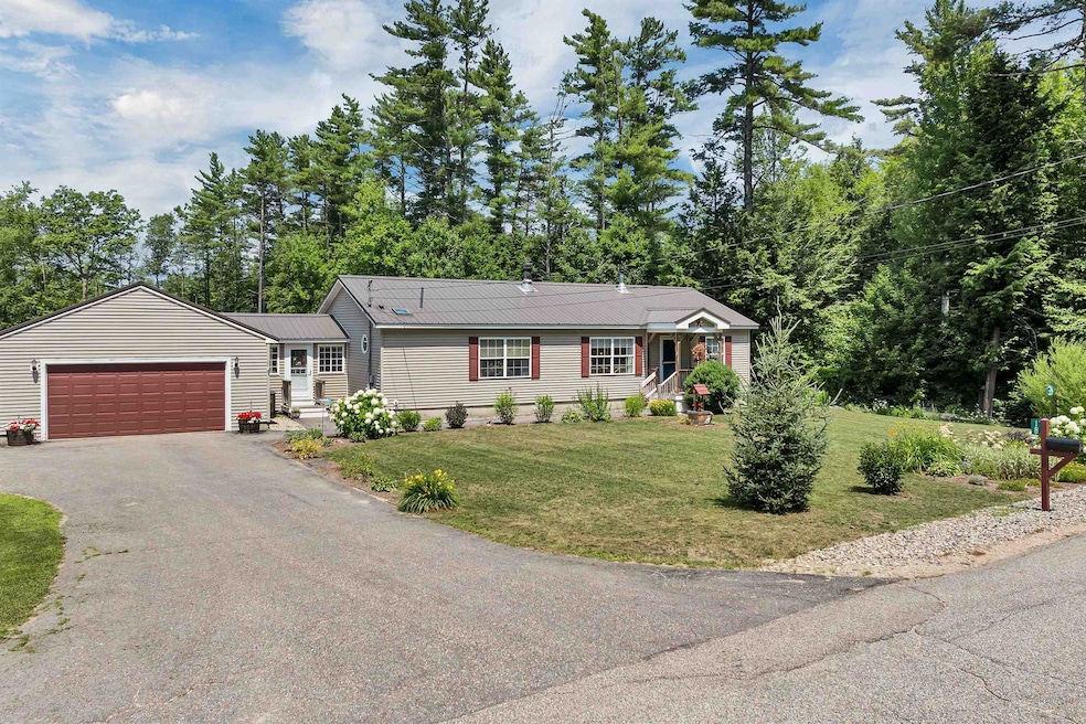


18 Butternut Ln Center Tuftonboro, NH 03816
Estimated payment $3,259/month
Highlights
- Mud Room
- 2 Car Direct Access Garage
- Living Room
- Tuftonboro Central School Rated A-
- Natural Light
- Dining Room
About This Home
Welcome to Tuftonboro Colony—a peaceful, well-established neighborhood in low-tax Tuftonboro, just minutes from Lake Winnipesaukee. Set on a beautifully landscaped 1.06-acre lot this thoughtfully updated home offers the best of single-level living with 3 bedrooms and 2 bathrooms. Recent renovations include stylish new flooring, an upgraded kitchen with modern finishes, a durable standing-seam metal roof, and a bright four-season breezeway perfect for year-round enjoyment. Step outside and enjoy the above-ground pool! The backyard is ideal for entertaining by the fire pit or enjoying the perennial gardens. Located just minutes from public beaches, marinas, and boat launches, this move-in-ready home offers both serenity and access to the best of the Lakes Region lifestyle. A turnkey gem not to be missed!
Home Details
Home Type
- Single Family
Est. Annual Taxes
- $2,679
Year Built
- Built in 2000
Lot Details
- 1.06 Acre Lot
- Property is zoned MDR-ME
Parking
- 2 Car Direct Access Garage
- Automatic Garage Door Opener
- 1 to 5 Parking Spaces
Home Design
- Concrete Foundation
- Wood Frame Construction
- Metal Roof
Interior Spaces
- Property has 1 Level
- Ceiling Fan
- Natural Light
- Mud Room
- Living Room
- Dining Room
- Basement
- Interior Basement Entry
- Washer
Kitchen
- Gas Range
- Dishwasher
Flooring
- Carpet
- Laminate
Bedrooms and Bathrooms
- 3 Bedrooms
- En-Suite Bathroom
- 2 Full Bathrooms
Schools
- Tuftonboro Central Elementary School
- Kingswood Regional Middle School
- Kingswood Regional High School
Utilities
- Mini Split Air Conditioners
- Drilled Well
- Leach Field
- Cable TV Available
Listing and Financial Details
- Legal Lot and Block 24 / 2
- Assessor Parcel Number 43
Map
Home Values in the Area
Average Home Value in this Area
Tax History
| Year | Tax Paid | Tax Assessment Tax Assessment Total Assessment is a certain percentage of the fair market value that is determined by local assessors to be the total taxable value of land and additions on the property. | Land | Improvement |
|---|---|---|---|---|
| 2024 | $2,832 | $371,700 | $72,500 | $299,200 |
| 2023 | $2,679 | $368,500 | $72,500 | $296,000 |
| 2022 | $2,373 | $368,500 | $72,500 | $296,000 |
| 2021 | $2,471 | $245,100 | $60,100 | $185,000 |
| 2020 | $2,304 | $241,000 | $60,100 | $180,900 |
| 2019 | $2,437 | $241,000 | $60,100 | $180,900 |
| 2018 | $2,180 | $199,100 | $67,100 | $132,000 |
| 2017 | $2,144 | $199,100 | $67,100 | $132,000 |
| 2016 | $2,077 | $199,100 | $67,100 | $132,000 |
| 2015 | $2,069 | $199,100 | $67,100 | $132,000 |
| 2014 | $1,989 | $199,100 | $67,100 | $132,000 |
| 2012 | $1,909 | $208,900 | $80,200 | $128,700 |
Property History
| Date | Event | Price | Change | Sq Ft Price |
|---|---|---|---|---|
| 07/21/2025 07/21/25 | For Sale | $575,000 | -- | $410 / Sq Ft |
Purchase History
| Date | Type | Sale Price | Title Company |
|---|---|---|---|
| Warranty Deed | -- | None Available | |
| Not Resolvable | $76,000 | -- | |
| Foreclosure Deed | $184,500 | -- |
Mortgage History
| Date | Status | Loan Amount | Loan Type |
|---|---|---|---|
| Open | $150,000 | Stand Alone Refi Refinance Of Original Loan |
Source: PrimeMLS
MLS Number: 5052519
APN: TUFT-000043-000002-000024
Disclaimer: Certain information contained herein is derived from information provided by parties other than Homes.com. All information provided is deemed reliable, but is not guaranteed to be accurate and should be independently verified.
![]() Copyright 2025 PrimeMLS, Inc. All rights reserved. This information is deemed reliable, but not guaranteed. The data relating to real estate displayed on this display comes in part from the IDX Program of PrimeMLS. The information being provided is for consumers’ personal, non-commercial use and may not be used for any purpose other than to identify prospective properties consumers may be interested in purchasing.
Copyright 2025 PrimeMLS, Inc. All rights reserved. This information is deemed reliable, but not guaranteed. The data relating to real estate displayed on this display comes in part from the IDX Program of PrimeMLS. The information being provided is for consumers’ personal, non-commercial use and may not be used for any purpose other than to identify prospective properties consumers may be interested in purchasing.
- 2 Oak Leaf Ave
- 106 Middle Rd
- 806 N Line Rd
- 12 Lisden Dr
- 61 Union Wharf Rd
- Lot 4 Vere Royce Rd
- 32 Juniper Dr
- 14 Pine Tree Dr
- 33 Juniper Dr
- 82 Spruce Dr
- 61 Dame Rd
- 15 Federal Corner Rd
- 155 Middle Rd
- 113 Federal Corner Rd
- Lot 4 Ridge Field Rd Unit 4
- 11 Winners Circle Farm Rd
- 0 Ledge Hill Rd Unit 5051045
- 323 Governor Wentworth Hwy
- 190 Ledge Hill Rd
- 105 Cow Island
- 738 N Line Rd
- 19 Mirror Lake Dr
- 18 N Line Rd
- 12 Norma Ln
- 47 Winterhaven Rd
- 487 Forest Rd
- 15 Lehner St Unit 3
- 61 Westwood Dr
- 38 Parker Island Rd
- 44 Parker Island Rd
- 8 Edgewood Terrace
- 2415 Lake Shore Rd
- 15 Homestead Ln
- 19 Ben Berry Rd
- 959 Whittier Hwy Unit Winnipesaukee Commons Unit #4
- 118 Woodlands Rd
- 65 Dockham Shore Rd
- 60 Weirs Rd Unit F6
- 17 Basin Rd
- 136 Weirs Rd Unit 32
