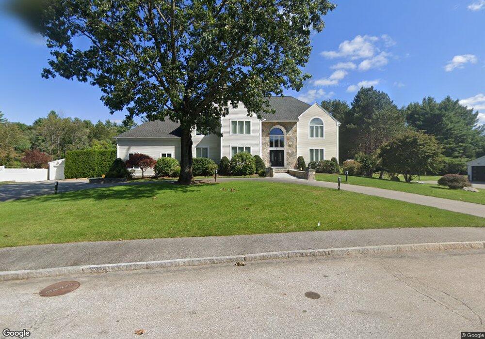
18 Powers Rd Andover, MA 01810
Estimated Value: $1,616,000 - $2,021,000
4
Beds
5
Baths
5,733
Sq Ft
$321/Sq Ft
Est. Value
About This Home
This home is located at 18 Powers Rd, Andover, MA 01810 and is currently estimated at $1,838,214, approximately $320 per square foot. 18 Powers Rd is a home located in Essex County with nearby schools including South Elementary School, Doherty Middle School, and Andover High School.
Ownership History
Date
Name
Owned For
Owner Type
Purchase Details
Closed on
Jun 22, 2018
Sold by
Cartolano Karen and Cartolano Joseph
Bought by
Joseph Cartolano Ret and Manzelli-Cartolano
Current Estimated Value
Purchase Details
Closed on
Jan 9, 1991
Sold by
Wynwood Assoc Inc
Bought by
Cartolano Joseph
Create a Home Valuation Report for This Property
The Home Valuation Report is an in-depth analysis detailing your home's value as well as a comparison with similar homes in the area
Purchase History
| Date | Buyer | Sale Price | Title Company |
|---|---|---|---|
| Joseph Cartolano Ret | -- | -- | |
| Joseph Cartolano Ret | -- | -- | |
| Cartolano Joseph | $158,000 | -- | |
| Cartolano Joseph | $158,000 | -- |
Source: Public Records
Mortgage History
| Date | Status | Borrower | Loan Amount |
|---|---|---|---|
| Previous Owner | Cartolano Joseph | $100,000 | |
| Previous Owner | Cartolano Joseph | $243,000 | |
| Previous Owner | Cartolano Joseph | $250,000 |
Source: Public Records
Tax History
| Year | Tax Paid | Tax Assessment Tax Assessment Total Assessment is a certain percentage of the fair market value that is determined by local assessors to be the total taxable value of land and additions on the property. | Land | Improvement |
|---|---|---|---|---|
| 2024 | $17,740 | $1,377,300 | $496,700 | $880,600 |
| 2023 | $16,757 | $1,226,700 | $424,700 | $802,000 |
| 2022 | $16,334 | $1,118,800 | $382,700 | $736,100 |
| 2021 | $17,478 | $1,143,100 | $460,900 | $682,200 |
| 2020 | $17,005 | $1,132,900 | $460,900 | $672,000 |
| 2019 | $16,270 | $1,065,500 | $429,600 | $635,900 |
| 2018 | $15,756 | $1,007,400 | $416,900 | $590,500 |
| 2017 | $15,151 | $998,100 | $408,800 | $589,300 |
| 2016 | $14,844 | $1,001,600 | $408,800 | $592,800 |
| 2015 | $14,563 | $972,800 | $408,800 | $564,000 |
Source: Public Records
Map
Nearby Homes
- 13 Taylor Cove Dr Unit 31
- 2 Clover Cir
- 56 Sunset Rock Rd
- 3 West Hollow
- 11 Gould Rd
- 331 S Main St
- 5 Colonial Dr Unit B5-6
- 1 Colonial Dr Unit C1-6
- 4 Hammond Way
- 31 Porter Rd
- 4 Hazelwood Cir
- 11 Cogswell Rd
- 12 Parkview Terrace
- 133B Salem
- 104 Salem St
- 53 Salem St
- 105 Central St
- 3 Torr St
- 3 Seneca Cir
- 250 Martins Landing Unit 402