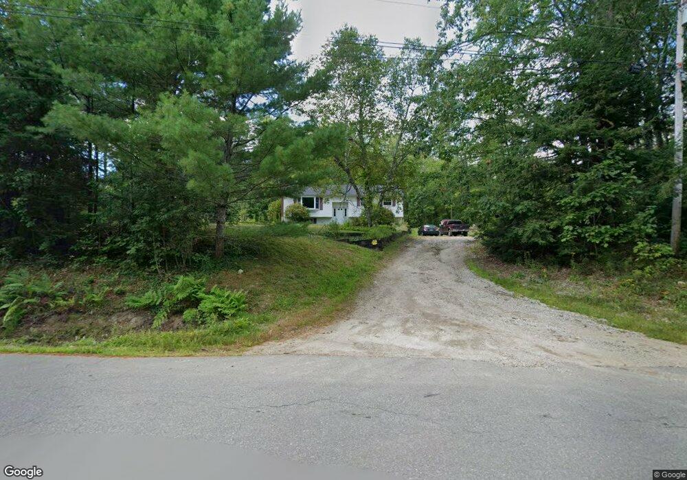
18 Swan Point Rd Rindge, NH 03461
Estimated Value: $392,900 - $483,000
3
Beds
1
Bath
1,878
Sq Ft
$229/Sq Ft
Est. Value
About This Home
This home is located at 18 Swan Point Rd, Rindge, NH 03461 and is currently estimated at $430,475, approximately $229 per square foot. 18 Swan Point Rd is a home located in Cheshire County with nearby schools including Rindge Memorial School, Conant Middle High School, and Conant High School.
Ownership History
Date
Name
Owned For
Owner Type
Purchase Details
Closed on
Nov 1, 1972
Bought by
Hannon Joseph D
Current Estimated Value
Create a Home Valuation Report for This Property
The Home Valuation Report is an in-depth analysis detailing your home's value as well as a comparison with similar homes in the area
Home Values in the Area
Average Home Value in this Area
Purchase History
| Date | Buyer | Sale Price | Title Company |
|---|---|---|---|
| Hannon Joseph D | -- | -- |
Source: Public Records
Mortgage History
| Date | Status | Borrower | Loan Amount |
|---|---|---|---|
| Open | Hannon Joseph D | $84,600 | |
| Closed | Hannon Joseph D | $82,634 |
Source: Public Records
Tax History Compared to Growth
Tax History
| Year | Tax Paid | Tax Assessment Tax Assessment Total Assessment is a certain percentage of the fair market value that is determined by local assessors to be the total taxable value of land and additions on the property. | Land | Improvement |
|---|---|---|---|---|
| 2024 | $5,194 | $205,200 | $49,800 | $155,400 |
| 2023 | $5,138 | $205,200 | $49,800 | $155,400 |
| 2022 | $4,092 | $177,700 | $49,800 | $127,900 |
| 2021 | $4,025 | $177,700 | $49,800 | $127,900 |
| 2020 | $7,707 | $177,700 | $49,800 | $127,900 |
| 2019 | $8,121 | $143,900 | $38,800 | $105,100 |
| 2018 | $4,343 | $143,900 | $38,800 | $105,100 |
| 2017 | $3,791 | $143,900 | $38,800 | $105,100 |
| 2016 | $6,344 | $143,900 | $38,800 | $105,100 |
| 2015 | $4,013 | $143,900 | $38,800 | $105,100 |
| 2014 | $4,633 | $178,000 | $64,800 | $113,200 |
| 2013 | $4,522 | $177,600 | $64,800 | $112,800 |
Source: Public Records
Map
Nearby Homes
- 46 Swan Point Rd
- 30 Cattail Cir
- 64 Old Ashburnham Rd
- 307 Main St
- 336 Main St
- 28 Wellington Rd
- 243 Main St
- 110 Red Gate Ln
- 286 Old New Ipswich Rd
- 7 Emerson Dr
- 19 Monomonac Terrace
- 54 Payson Hill Rd
- 125 2nd St
- 196 Lord Brook Rd
- 145 Monomonac Rd E
- Lot 15 Saybrook Dr
- Lot 4 Saybrook Dr
- 15 2nd St
- 16 2nd St
- Lot 1 Saybrook Dr
- 356 Wellington Rd
- 39 Swan Point Rd
- 31 Swan Point Rd
- 50 Converseville Rd
- 36 Miller Ave
- 43 Swan Point Rd
- 24 Conversevill Rd
- 12 Miller Ave
- 46 Converseville Rd
- 64 Converseville Rd
- 341 Wellington Rd
- 59 Converseville Rd
- 55 Swan Point Rd
- 37 Converseville Rd
- 330 Wellington Rd
- 325 Wellington Rd
- 70 Swan Point Rd
- 72 Tico Rd
- 1 Tico Rd
- 49 Converseville Rd