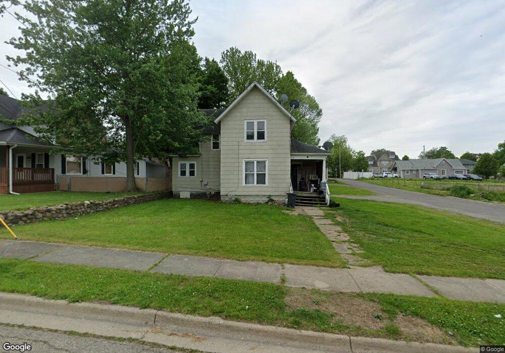
18 Whittier Ave Battle Creek, MI 49015
Central Battle Creek NeighborhoodEstimated Value: $116,000 - $137,298
4
Beds
2
Baths
1,569
Sq Ft
$81/Sq Ft
Est. Value
About This Home
This home is located at 18 Whittier Ave, Battle Creek, MI 49015 and is currently estimated at $126,325, approximately $80 per square foot. 18 Whittier Ave is a home located in Calhoun County with nearby schools including Ann J. Kellogg School, Springfield Middle School, and Battle Creek Central High School.
Ownership History
Date
Name
Owned For
Owner Type
Purchase Details
Closed on
Nov 25, 2008
Sold by
Battle Creek Area Habitat For Humanity
Bought by
Heath Edward Tichenor
Current Estimated Value
Purchase Details
Closed on
Jun 13, 2008
Sold by
Brown Nanette J
Bought by
Battle Creek Area Habitat For Humanity I
Purchase Details
Closed on
Mar 18, 2003
Bought by
Brown Nanette J
Purchase Details
Closed on
Jan 6, 2003
Sold by
Ashworth Lee
Bought by
Bankers Trust Co Of California
Purchase Details
Closed on
Feb 5, 1999
Bought by
Ashworth
Purchase Details
Closed on
Feb 23, 1998
Bought by
Ashworth
Purchase Details
Closed on
Jun 7, 1995
Bought by
Embury
Create a Home Valuation Report for This Property
The Home Valuation Report is an in-depth analysis detailing your home's value as well as a comparison with similar homes in the area
Home Values in the Area
Average Home Value in this Area
Purchase History
| Date | Buyer | Sale Price | Title Company |
|---|---|---|---|
| Heath Edward Tichenor | $8,500 | First American Title Ins Co | |
| Battle Creek Area Habitat For Humanity I | $6,000 | None Available | |
| Brown Nanette J | $18,000 | -- | |
| Bankers Trust Co Of California | $20,700 | -- | |
| Ashworth | $14,000 | -- | |
| Ashworth | $14,000 | -- | |
| Embury | $8,000 | -- |
Source: Public Records
Tax History Compared to Growth
Tax History
| Year | Tax Paid | Tax Assessment Tax Assessment Total Assessment is a certain percentage of the fair market value that is determined by local assessors to be the total taxable value of land and additions on the property. | Land | Improvement |
|---|---|---|---|---|
| 2025 | -- | $33,400 | $0 | $0 |
| 2024 | $799 | $34,775 | $0 | $0 |
| 2023 | $1,017 | $34,905 | $0 | $0 |
| 2022 | $723 | $28,476 | $0 | $0 |
| 2021 | $967 | $20,344 | $0 | $0 |
| 2020 | $911 | $15,623 | $0 | $0 |
| 2019 | $912 | $15,304 | $0 | $0 |
| 2018 | $912 | $14,080 | $640 | $13,440 |
| 2017 | $906 | $15,750 | $0 | $0 |
| 2016 | $903 | $15,750 | $0 | $0 |
| 2015 | $1,059 | $13,999 | $3,111 | $10,888 |
| 2014 | $1,059 | $16,485 | $3,111 | $13,374 |
Source: Public Records
Map
Nearby Homes
- 17 Tennyson Ave
- 57 Boulder St
- 96 Battle Creek Ave
- 66 Cleveland St
- 35 Eldred St
- 71 Burnham St W
- 171 Goguac St W
- 296 Meachem Ave
- 111 Burnham St W
- 210 Battle Creek Ave
- 212 Goguac St W
- 41 Randolph St
- 1 Grand Blvd
- 178 Webber St
- 100 Eldred St
- 21 Spring St
- 32 Territorial Rd E
- 30 Harris St
- 39 Harris St
- 9 Foster Ave
- 24 Whittier Ave
- 377 Capital Ave SW
- 30 Whittier Ave
- 19 Tennyson Ave
- 23 Tennyson Ave
- 17 Whittier Ave
- 369 Capital Ave SW
- 387 Capital Ave SW
- 23 Whittier Ave
- 29 Tennyson Ave
- 36 Whittier Ave
- 365 Capital Ave SW
- 29 Whittier Ave
- 33 Tennyson Ave
- 363 Capital Ave SW
- 582 Capital Ave SW
- 33 Whittier Ave
- 37 Tennyson Ave
- 42 Whittier Ave
- 12 Tennyson Ave