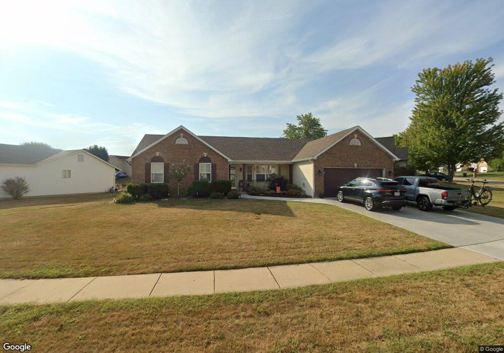
18 Wistar Way O Fallon, MO 63366
Estimated Value: $363,700 - $385,000
3
Beds
2
Baths
1,780
Sq Ft
$210/Sq Ft
Est. Value
About This Home
This home is located at 18 Wistar Way, O Fallon, MO 63366 and is currently estimated at $373,425, approximately $209 per square foot. 18 Wistar Way is a home located in St. Charles County with nearby schools including Rock Creek Elementary School, Fort Zumwalt West Middle School, and Fort Zumwalt West High School.
Ownership History
Date
Name
Owned For
Owner Type
Purchase Details
Closed on
Jan 29, 2025
Sold by
Regan Timothy F
Bought by
Regan Joint Revocable Living Trust and Regan
Current Estimated Value
Purchase Details
Closed on
Aug 29, 2003
Sold by
Bauche Faith E and Bauche Lee E
Bought by
Regan Timothy F
Home Financials for this Owner
Home Financials are based on the most recent Mortgage that was taken out on this home.
Original Mortgage
$126,400
Interest Rate
6.26%
Mortgage Type
Purchase Money Mortgage
Create a Home Valuation Report for This Property
The Home Valuation Report is an in-depth analysis detailing your home's value as well as a comparison with similar homes in the area
Home Values in the Area
Average Home Value in this Area
Purchase History
| Date | Buyer | Sale Price | Title Company |
|---|---|---|---|
| Regan Joint Revocable Living Trust | -- | None Listed On Document | |
| Regan Timothy F | $158,000 | Capital Title Co Inc |
Source: Public Records
Mortgage History
| Date | Status | Borrower | Loan Amount |
|---|---|---|---|
| Previous Owner | Regan Timothy F | $126,400 |
Source: Public Records
Tax History
| Year | Tax Paid | Tax Assessment Tax Assessment Total Assessment is a certain percentage of the fair market value that is determined by local assessors to be the total taxable value of land and additions on the property. | Land | Improvement |
|---|---|---|---|---|
| 2025 | $3,722 | $63,816 | -- | -- |
| 2023 | $3,724 | $56,240 | $0 | $0 |
| 2022 | $3,363 | $47,227 | $0 | $0 |
| 2021 | $3,366 | $47,227 | $0 | $0 |
| 2020 | $3,220 | $43,768 | $0 | $0 |
| 2019 | $3,227 | $43,768 | $0 | $0 |
| 2018 | $3,011 | $38,973 | $0 | $0 |
| 2017 | $2,972 | $38,973 | $0 | $0 |
| 2016 | $2,778 | $36,284 | $0 | $0 |
| 2015 | $2,582 | $36,284 | $0 | $0 |
| 2014 | $2,426 | $33,509 | $0 | $0 |
Source: Public Records
Map
Nearby Homes
- 14 Spangle Way Dr
- 3 Pinehurst Forest Ct
- 1234 Pinehurst Club Ct
- 20 Cherokee Sunset Ct Ct
- 962 Midpoint Dr
- 10 Southern Hills Ct
- 11 Southern Hills Ct
- 8 Winter Forest Ct
- 1117 Turtle Creek Dr
- 140 Weatherby Landing Dr
- 109 Sterling Crossing Dr
- 217 Roaring River Dr
- 151 N Wellington St
- 2325 Sundance Dr
- 5 Challenger Ct
- 105 Columbia Meadows Ln
- 116 Columbia Meadows Ln
- 220 Discovery Meadows Place
- 4 Challenger Ct
- 1 Grand Columbia @ Columbia Meadows
Your Personal Tour Guide
Ask me questions while you tour the home.