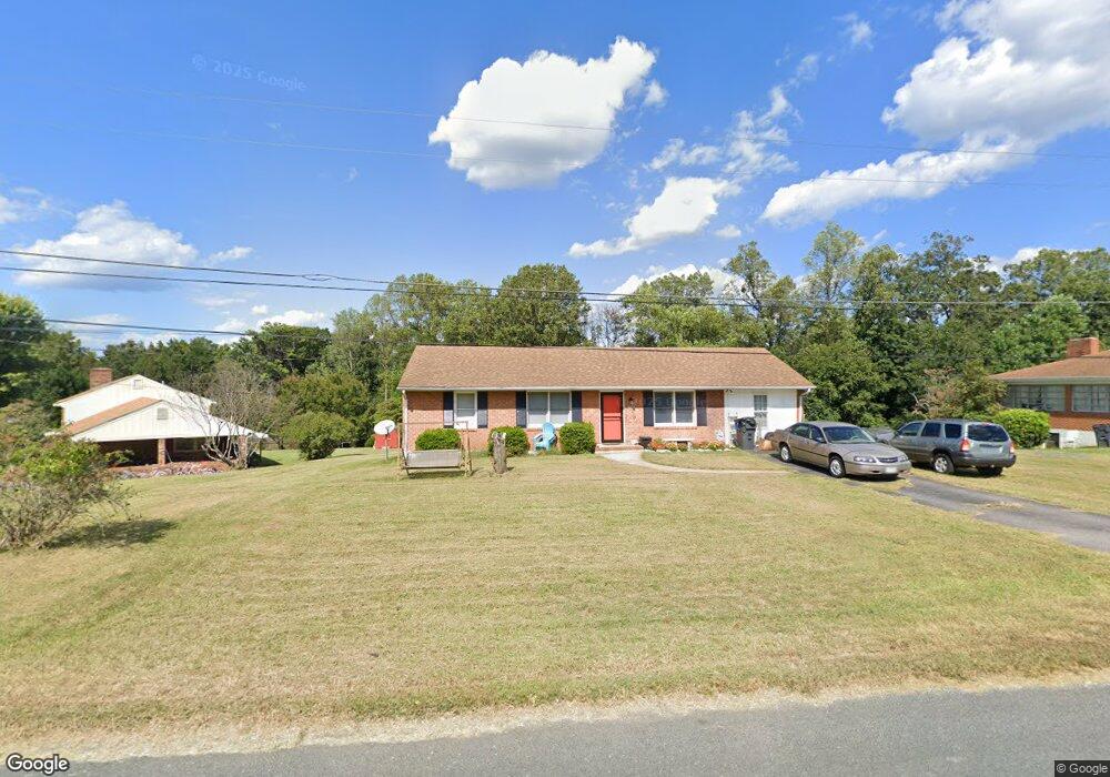
180 Moorman Dr Madison Heights, VA 24572
Estimated Value: $175,000 - $195,000
3
Beds
2
Baths
1,075
Sq Ft
$174/Sq Ft
Est. Value
About This Home
This home is located at 180 Moorman Dr, Madison Heights, VA 24572 and is currently estimated at $187,021, approximately $173 per square foot. 180 Moorman Dr is a home located in Amherst County with nearby schools including Madison Heights Elementary School, Monelison Middle School, and Amherst County High School.
Ownership History
Date
Name
Owned For
Owner Type
Purchase Details
Closed on
Nov 29, 2006
Sold by
Mays Isabella S and Saunders Evertt J
Bought by
Brust Jeremy S and Brust Barndy M
Current Estimated Value
Home Financials for this Owner
Home Financials are based on the most recent Mortgage that was taken out on this home.
Original Mortgage
$105,112
Outstanding Balance
$63,504
Interest Rate
6.5%
Mortgage Type
VA
Estimated Equity
$123,518
Create a Home Valuation Report for This Property
The Home Valuation Report is an in-depth analysis detailing your home's value as well as a comparison with similar homes in the area
Home Values in the Area
Average Home Value in this Area
Purchase History
| Date | Buyer | Sale Price | Title Company |
|---|---|---|---|
| Brust Jeremy S | -- | None Available |
Source: Public Records
Mortgage History
| Date | Status | Borrower | Loan Amount |
|---|---|---|---|
| Open | Brust Jeremy S | $105,112 |
Source: Public Records
Tax History Compared to Growth
Tax History
| Year | Tax Paid | Tax Assessment Tax Assessment Total Assessment is a certain percentage of the fair market value that is determined by local assessors to be the total taxable value of land and additions on the property. | Land | Improvement |
|---|---|---|---|---|
| 2025 | $550 | $90,100 | $27,500 | $62,600 |
| 2024 | $550 | $90,100 | $27,500 | $62,600 |
| 2023 | $550 | $90,100 | $27,500 | $62,600 |
| 2022 | $550 | $90,100 | $27,500 | $62,600 |
| 2021 | $550 | $90,100 | $27,500 | $62,600 |
| 2020 | $550 | $90,100 | $27,500 | $62,600 |
| 2019 | $536 | $87,800 | $28,500 | $59,300 |
| 2018 | $536 | $87,800 | $28,500 | $59,300 |
| 2017 | $536 | $87,800 | $28,500 | $59,300 |
| 2016 | $536 | $87,800 | $28,500 | $59,300 |
| 2015 | $492 | $87,800 | $28,500 | $59,300 |
| 2014 | $492 | $87,800 | $28,500 | $59,300 |
Source: Public Records
Map
Nearby Homes
- 174 Moorman Dr
- 104 River Ridge Rd
- 168 Moorman Dr
- 177 Moorman Dr
- 114 River Ridge Rd
- 193 Moorman Dr
- 167 Moorman Dr
- 118 River Ridge Rd
- 156 Moorman Dr
- 113 River Ridge Rd
- 213 Moorman Dr
- 153 Moorman Dr
- 148 Moorman Dr
- 219 Moorman Dr
- 208 Moorman Dr
- 132 River Ridge Rd
- 145 Moorman Dr
- 128 River Ridge Rd
- 140 Moorman Dr
- 147 River Ridge Rd