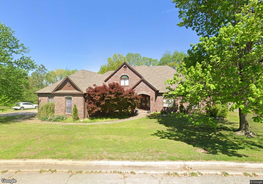
1801 E Lee Ave Sapulpa, OK 74066
Estimated Value: $488,000 - $535,520
4
Beds
5
Baths
3,698
Sq Ft
$138/Sq Ft
Est. Value
About This Home
This home is located at 1801 E Lee Ave, Sapulpa, OK 74066 and is currently estimated at $510,630, approximately $138 per square foot. 1801 E Lee Ave is a home located in Creek County with nearby schools including Sapulpa Junior High School, Sapulpa Middle School, and Sapulpa High School.
Ownership History
Date
Name
Owned For
Owner Type
Purchase Details
Closed on
Feb 23, 2023
Sold by
Ryan James Michael Scott and Ryan Melinda Johns
Bought by
Ryan Family Revocable Trust
Current Estimated Value
Purchase Details
Closed on
Mar 15, 2007
Sold by
Ryan James Michael S and Ryan Melinda Johnson
Bought by
Ryan James Michael S and Ryan Melinda Johnson
Home Financials for this Owner
Home Financials are based on the most recent Mortgage that was taken out on this home.
Original Mortgage
$30,000
Interest Rate
6.26%
Mortgage Type
New Conventional
Create a Home Valuation Report for This Property
The Home Valuation Report is an in-depth analysis detailing your home's value as well as a comparison with similar homes in the area
Home Values in the Area
Average Home Value in this Area
Purchase History
| Date | Buyer | Sale Price | Title Company |
|---|---|---|---|
| Ryan Family Revocable Trust | -- | -- | |
| Ryan James Michael S | -- | Midwest Title Services |
Source: Public Records
Mortgage History
| Date | Status | Borrower | Loan Amount |
|---|---|---|---|
| Previous Owner | Ryan James Michael S | $30,000 |
Source: Public Records
Tax History Compared to Growth
Tax History
| Year | Tax Paid | Tax Assessment Tax Assessment Total Assessment is a certain percentage of the fair market value that is determined by local assessors to be the total taxable value of land and additions on the property. | Land | Improvement |
|---|---|---|---|---|
| 2025 | $5,317 | $46,079 | $8,400 | $37,679 |
| 2024 | $5,317 | $44,737 | $8,400 | $36,337 |
| 2023 | $5,317 | $43,434 | $8,400 | $35,034 |
| 2022 | $4,729 | $42,169 | $8,400 | $33,769 |
| 2021 | $4,739 | $40,941 | $8,400 | $32,541 |
| 2020 | $5,192 | $45,014 | $8,400 | $36,614 |
| 2019 | $5,331 | $45,968 | $8,400 | $37,568 |
| 2018 | $5,280 | $44,629 | $8,400 | $36,229 |
| 2017 | $5,163 | $43,890 | $8,348 | $35,542 |
| 2016 | $4,762 | $42,611 | $8,257 | $34,354 |
| 2015 | -- | $41,370 | $8,169 | $33,201 |
| 2014 | -- | $40,165 | $8,084 | $32,081 |
Source: Public Records
Map
Nearby Homes
- 6 Mayfield St
- 0 Line St Unit 2546638
- 420 Shadow Ln
- 103 Woodview Ln
- 436 Foxwood Dr
- 1411 E Denton Ave
- 505 N Ross St
- 0 E Taft St
- 1140 E Hobson Ave
- 758 N Moccasin Place
- 1136 E Mcleod Ave
- 819 Ridge Rd
- 1805 Glendale Rd
- 543 N Ridgeway St
- 1033 E Thompson Ave
- 1608 Glendale Rd
- 1023 E Thompson Ave
- 802 N Boyd Cir
- 1137 E Perkins Ave
- 1010 E Thompson Ave
- 0 E Lee Ave
- 108 Lee Cir
- 105 Brenner Rd
- 1719 E Lee Ave
- 114 Lee Cir
- 1818 E Lee Ave
- 117 Brenner Rd
- 105 Lee Cir
- 106 Brenner Rd
- 1707 E Lee Ave
- 121 Lee Cir
- 123 Brenner Rd
- 2 Cornelius Ct
- 1826 E Lee Ave
- 118 Brenner Rd
- 1750 E Dewey Ave
- 23 S Rosewood Cir
- 0 Cornelius Ct Unit 1937931
- 0 Cornelius Ct Unit 1937930
- 1746 E Dewey Ave