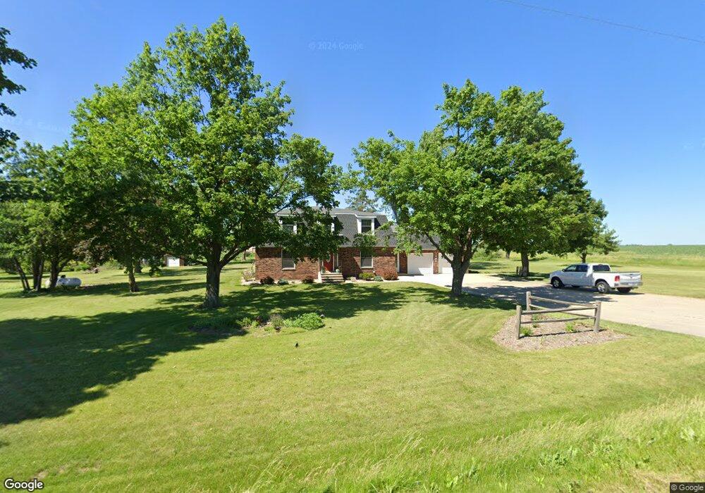
1801 Fernow Rd Marion, IA 52302
Estimated Value: $384,000 - $477,913
--
Bed
4
Baths
2,978
Sq Ft
$146/Sq Ft
Est. Value
About This Home
This home is located at 1801 Fernow Rd, Marion, IA 52302 and is currently estimated at $433,728, approximately $145 per square foot. 1801 Fernow Rd is a home located in Linn County with nearby schools including Linn Grove Elementary School, Excelsior Middle School, and Linn-Mar High School.
Ownership History
Date
Name
Owned For
Owner Type
Purchase Details
Closed on
Nov 28, 2006
Sold by
Farmers State Bank
Bought by
Falcon Walter P and Falcon Laura H
Current Estimated Value
Home Financials for this Owner
Home Financials are based on the most recent Mortgage that was taken out on this home.
Original Mortgage
$171,000
Interest Rate
6.38%
Mortgage Type
Purchase Money Mortgage
Purchase Details
Closed on
Oct 31, 2006
Sold by
Swallow Brookie C and Roundy Brookie C
Bought by
Lampe Shawn and Lampe Tina M
Home Financials for this Owner
Home Financials are based on the most recent Mortgage that was taken out on this home.
Original Mortgage
$171,000
Interest Rate
6.38%
Mortgage Type
Purchase Money Mortgage
Create a Home Valuation Report for This Property
The Home Valuation Report is an in-depth analysis detailing your home's value as well as a comparison with similar homes in the area
Home Values in the Area
Average Home Value in this Area
Purchase History
| Date | Buyer | Sale Price | Title Company |
|---|---|---|---|
| Falcon Walter P | -- | None Available | |
| Lampe Shawn | $189,500 | None Available |
Source: Public Records
Mortgage History
| Date | Status | Borrower | Loan Amount |
|---|---|---|---|
| Previous Owner | Lampe Shawn | $171,000 |
Source: Public Records
Tax History Compared to Growth
Tax History
| Year | Tax Paid | Tax Assessment Tax Assessment Total Assessment is a certain percentage of the fair market value that is determined by local assessors to be the total taxable value of land and additions on the property. | Land | Improvement |
|---|---|---|---|---|
| 2025 | $5,170 | $496,200 | $78,000 | $418,200 |
| 2024 | $4,512 | $395,000 | $78,000 | $317,000 |
| 2023 | $4,512 | $395,000 | $78,000 | $317,000 |
| 2022 | $4,366 | $296,200 | $78,000 | $218,200 |
| 2021 | $4,354 | $296,200 | $78,000 | $218,200 |
| 2020 | $4,354 | $275,700 | $55,000 | $220,700 |
| 2019 | $4,078 | $259,200 | $55,000 | $204,200 |
| 2018 | $3,894 | $259,200 | $55,000 | $204,200 |
| 2017 | $3,746 | $241,600 | $55,000 | $186,600 |
| 2016 | $3,785 | $241,600 | $55,000 | $186,600 |
| 2015 | $3,815 | $241,600 | $55,000 | $186,600 |
| 2014 | $3,678 | $241,600 | $55,000 | $186,600 |
| 2013 | $3,530 | $241,600 | $55,000 | $186,600 |
Source: Public Records
Map
Nearby Homes
- 2770 Burns Dr
- 2760 Burns Dr
- 2750 Burns Dr
- 2638 Fields Dr
- 2701 Roycroft Dr
- 2488 Bluegrass St
- 2465 Bluegrass St
- 2398 Bluegrass St
- 2466 Roycroft Alley
- 2390 Bluegrass St
- 2436 Roycroft Alley
- 2375 Bluegrass St
- 2367 Rookwood Ln
- 2734 Rookwood Ln
- 2700 Rookwood Ln
- 2362 Bluegrass St
- 2363 Rookwood Ln
- Lots 130-137 Rookwood Estates
- 6431 Rookwood Ln
- 0 Robinwood Ln
- 2614 Fields Dr
- 1811 Fernow Rd
- 2616 Fields Dr
- 1825 Fernow Rd
- 2625 Fields Dr
- 2622 Fields Dr
- 1826 Fernow Rd
- 1831 Fernow Rd
- 2634 Fields Dr
- 1837 Fernow Rd
- 2766 Rookwood Ln
- 2730 Burns Dr
- 2710 Burns Dr
- 2796 Roycroft Dr
- 1814 Somerset Dr
- 1766 Fernow Rd
- 1822 Somerset Dr
- 1806 Somerset Dr
- 1838 Fernow Rd
- 2700 Burns Dr