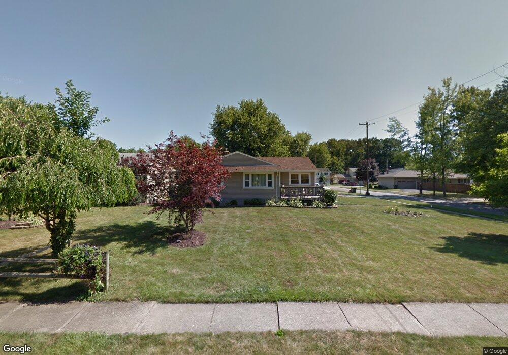
1801 Lealand Ave Youngstown, OH 44514
Estimated Value: $167,000 - $180,000
3
Beds
1
Bath
1,056
Sq Ft
$162/Sq Ft
Est. Value
About This Home
This home is located at 1801 Lealand Ave, Youngstown, OH 44514 and is currently estimated at $171,527, approximately $162 per square foot. 1801 Lealand Ave is a home located in Mahoning County with nearby schools including Poland Union Elementary School, Poland Middle School, and Poland Seminary High School.
Ownership History
Date
Name
Owned For
Owner Type
Purchase Details
Closed on
Aug 13, 2005
Sold by
Wright Floyd Lewis
Bought by
Lucente Phyllis A
Current Estimated Value
Home Financials for this Owner
Home Financials are based on the most recent Mortgage that was taken out on this home.
Original Mortgage
$64,800
Interest Rate
5.41%
Mortgage Type
Fannie Mae Freddie Mac
Purchase Details
Closed on
Sep 25, 1961
Bought by
Wright Floyd L and L M
Create a Home Valuation Report for This Property
The Home Valuation Report is an in-depth analysis detailing your home's value as well as a comparison with similar homes in the area
Home Values in the Area
Average Home Value in this Area
Purchase History
| Date | Buyer | Sale Price | Title Company |
|---|---|---|---|
| Lucente Phyllis A | $81,000 | -- | |
| Wright Floyd L | -- | -- |
Source: Public Records
Mortgage History
| Date | Status | Borrower | Loan Amount |
|---|---|---|---|
| Closed | Lucente Phyllis A | $64,800 |
Source: Public Records
Tax History Compared to Growth
Tax History
| Year | Tax Paid | Tax Assessment Tax Assessment Total Assessment is a certain percentage of the fair market value that is determined by local assessors to be the total taxable value of land and additions on the property. | Land | Improvement |
|---|---|---|---|---|
| 2024 | $2,479 | $47,720 | $6,420 | $41,300 |
| 2023 | $2,449 | $47,720 | $6,420 | $41,300 |
| 2022 | $1,981 | $31,970 | $5,620 | $26,350 |
| 2021 | $1,984 | $31,970 | $5,620 | $26,350 |
| 2020 | $1,992 | $31,970 | $5,620 | $26,350 |
| 2019 | $1,756 | $25,170 | $4,420 | $20,750 |
| 2018 | $1,625 | $25,170 | $4,420 | $20,750 |
| 2017 | $1,716 | $25,170 | $4,420 | $20,750 |
| 2016 | $1,829 | $27,560 | $6,520 | $21,040 |
| 2015 | $1,794 | $27,560 | $6,520 | $21,040 |
| 2014 | $1,800 | $27,560 | $6,520 | $21,040 |
| 2013 | $1,779 | $27,560 | $6,520 | $21,040 |
Source: Public Records
Map
Nearby Homes
- 1859 Mathews Rd
- 0 Mathews Rd Unit 5149232
- 0 Mathews Rd Unit 5143059
- 1894 Lealand Ave
- 1890 Mathews Rd
- 0 Oles Ave
- 1804 Alverne Dr
- 0 Woodlawn Ave
- 1827 Alverne Dr
- 1841 Wingate Rd
- 1738 Island Dr
- 2035 Woodward Ave
- 1919 Wingate Rd
- 5710 Youngstown Poland Rd
- 1828 Basil Ave
- 928 Edenridge Dr
- 34 Venloe Dr
- 43 Venloe Dr
- 2128 Lyon Blvd
- 2035 Holbrook Rd
- 1809 Lealand Ave
- 1799 Lealand Ave
- 1788 Lemont Dr
- 1792 Lemont Dr
- 1796 Lemont Dr
- 1802 Lealand Ave
- 1786 Lemont Dr
- 1813 Lealand Ave
- 1806 Lealand Ave
- 1793 Lealand Ave
- 1810 Lealand Ave
- 1798 Lealand Ave
- 1800 Lemont Dr
- 1784 Lemont Dr
- 1787 Lealand Ave
- 1814 Lealand Ave
- 1792 Lealand Ave
- 1817 Lealand Ave
- 1804 Lemont Dr
- 1780 Lemont Dr