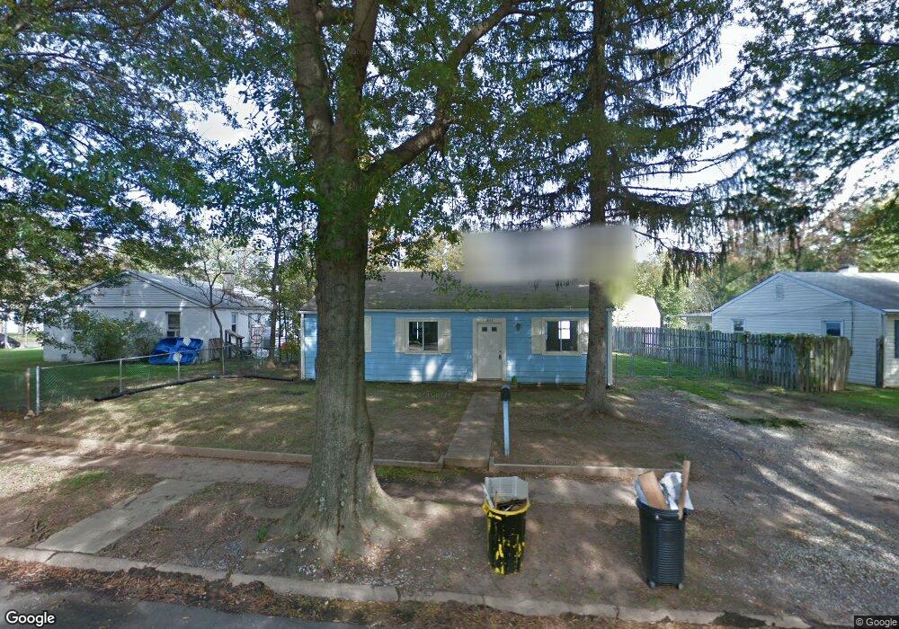
1802 Saunders Way Glen Burnie, MD 21061
Estimated Value: $234,906 - $337,000
3
Beds
1
Bath
988
Sq Ft
$284/Sq Ft
Est. Value
About This Home
This home is located at 1802 Saunders Way, Glen Burnie, MD 21061 and is currently estimated at $280,977, approximately $284 per square foot. 1802 Saunders Way is a home located in Anne Arundel County with nearby schools including Woodside Elementary School, Corkran Middle School, and Glen Burnie High School.
Ownership History
Date
Name
Owned For
Owner Type
Purchase Details
Closed on
Mar 3, 2023
Sold by
Astor Christopher J
Bought by
Astor Jason C
Current Estimated Value
Purchase Details
Closed on
Apr 1, 2004
Sold by
Brown Charles F
Bought by
Astor Christopher J
Purchase Details
Closed on
Dec 23, 1998
Sold by
Bougourd Patrick J
Bought by
Brown Charles F and Brown Janet L
Purchase Details
Closed on
Dec 10, 1992
Sold by
Dash Claude D
Bought by
Bougourd Patrick J
Create a Home Valuation Report for This Property
The Home Valuation Report is an in-depth analysis detailing your home's value as well as a comparison with similar homes in the area
Home Values in the Area
Average Home Value in this Area
Purchase History
| Date | Buyer | Sale Price | Title Company |
|---|---|---|---|
| Astor Jason C | -- | -- | |
| Astor Christopher J | $121,905 | -- | |
| Brown Charles F | $93,000 | -- | |
| Bougourd Patrick J | $84,000 | -- |
Source: Public Records
Mortgage History
| Date | Status | Borrower | Loan Amount |
|---|---|---|---|
| Closed | Brown Charles F | -- |
Source: Public Records
Tax History Compared to Growth
Tax History
| Year | Tax Paid | Tax Assessment Tax Assessment Total Assessment is a certain percentage of the fair market value that is determined by local assessors to be the total taxable value of land and additions on the property. | Land | Improvement |
|---|---|---|---|---|
| 2025 | $2,747 | $217,900 | $143,100 | $74,800 |
| 2024 | $2,747 | $204,967 | $0 | $0 |
| 2023 | $2,571 | $192,033 | $0 | $0 |
| 2022 | $2,302 | $179,100 | $113,100 | $66,000 |
| 2021 | $2,260 | $175,133 | $0 | $0 |
| 2020 | $2,178 | $171,167 | $0 | $0 |
| 2019 | $2,138 | $167,200 | $103,100 | $64,100 |
| 2018 | $1,662 | $163,933 | $0 | $0 |
| 2017 | $2,020 | $160,667 | $0 | $0 |
| 2016 | -- | $157,400 | $0 | $0 |
| 2015 | -- | $149,033 | $0 | $0 |
| 2014 | -- | $140,667 | $0 | $0 |
Source: Public Records
Map
Nearby Homes
- 1731 Saunders Way
- 1701 Norfolk Rd
- 1921 Norwich Rd
- 1702 Manning Rd
- 8918 Twin Ridge Dr
- 1612 Lorimer Rd
- 1909 Pagham Rd
- 8903 Jeff Mar Dr
- 1613 Kimber Rd
- 8906 Jeff Mar Dr
- 100 Sandsbury Ave
- 405 Morningside Dr
- 180 Jessica Ln
- 206 Sandsbury Ave
- 1003 Lee Rd
- 338 White Oak Way
- 1318 Tarrant Rd
- 0 Irene Dr
- 301 Whitman Ct
- 7911 Ritchie Hwy
- 1804 Saunders Way
- 1800 Saunders Way
- 1707 Norfolk Rd
- 1806 Saunders Way
- 1705 Norfolk Rd
- 1805 Saunders Way
- 1803 Saunders Way
- 1807 Saunders Way
- 1801 Saunders Way
- 1808 Saunders Way
- 1809 Saunders Way
- 1703 Norfolk Rd
- 1730 Saunders Way
- 1708 Norfolk Rd
- 1811 Saunders Way
- 1710 Norfolk Rd
- 1706 Norfolk Rd
- 1810 Saunders Way
- 1813 Saunders Way
- 1815 Saunders Way