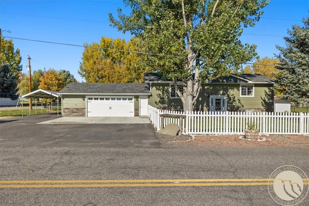
1805 E Maryland Ln Laurel, MT 59044
Estimated payment $2,794/month
Highlights
- RV or Boat Parking
- Deck
- Covered Patio or Porch
- 1.09 Acre Lot
- Corner Lot
- 2 Car Attached Garage
About This Home
If you’ve been online searching for “the one,” this home just might check every box!
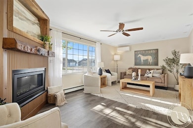
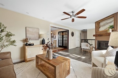
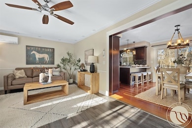
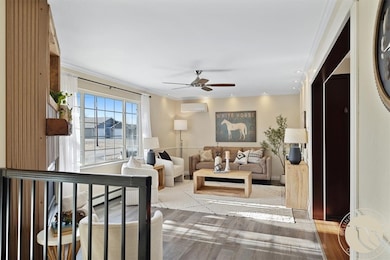
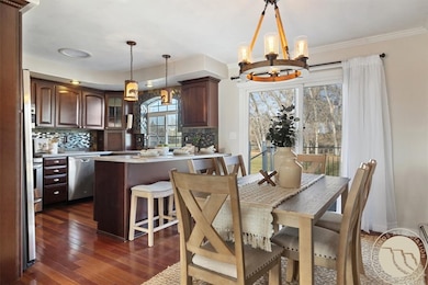
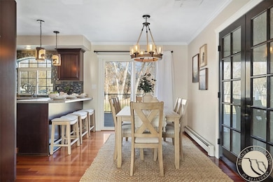
Beautifully updated 3-bedroom, 3-bathroom home featuring a custom kitchen and a HUGE sunny deck just off the dining room.
You’ll find tasteful updates throughout, including new paint, new flooring, updated tile in the bathrooms, and a new fireplace mantle that adds a fresh, warm touch to the living room. The lower level is an entertainer’s dream with a wet bar, spacious family room (pool table included!), a bedroom, and a brand-new full bathroom creating a perfect setup for guests or a private home office. Step outside to enjoy the covered patio and fire pit, ideal for relaxing and entertaining in any season. The heated garage and additional carport offer plentiful parking and storage.
All of this sits on one acre in a peaceful rural setting with a manicured yard and even a pasture for a horse!
Listing Agent
Meridian Real Estate LLC Brokerage Phone: 406-855-5725 Listed on: 11/19/2025
Home Details
Home Type
- Single Family
Est. Annual Taxes
- $1,971
Year Built
- Built in 1976
Lot Details
- 1.09 Acre Lot
- Fenced
- Landscaped
- Corner Lot
- Level Lot
- Sprinkler System
Parking
- 2 Car Attached Garage
- Additional Parking
- RV or Boat Parking
Home Design
- Asphalt Roof
- HardiePlank Type
Interior Spaces
- 2,200 Sq Ft Home
- 2-Story Property
- Ceiling Fan
- Gas Fireplace
- Basement Fills Entire Space Under The House
Kitchen
- Oven
- Gas Range
- Microwave
- Dishwasher
Bedrooms and Bathrooms
- 3 Bedrooms
- 3 Full Bathrooms
Outdoor Features
- Deck
- Covered Patio or Porch
- Shed
Schools
- Laurel Elementary And Middle School
- Laurel High School
Utilities
- Cooling Available
- Hot Water Heating System
- Well
- Septic Tank
Listing and Financial Details
- Assessor Parcel Number B01853A
Community Details
Overview
- High Point Subd Subdivision
Building Details
Map
Home Values in the Area
Average Home Value in this Area
Tax History
| Year | Tax Paid | Tax Assessment Tax Assessment Total Assessment is a certain percentage of the fair market value that is determined by local assessors to be the total taxable value of land and additions on the property. | Land | Improvement |
|---|---|---|---|---|
| 2025 | $2,403 | $420,300 | $106,685 | $313,615 |
| 2024 | $2,403 | $326,800 | $69,984 | $256,816 |
| 2023 | $2,328 | $326,800 | $69,984 | $256,816 |
| 2022 | $1,993 | $271,400 | $60,722 | $210,678 |
| 2021 | $1,987 | $271,400 | $0 | $0 |
| 2020 | $1,850 | $246,100 | $0 | $0 |
| 2019 | $1,783 | $246,100 | $0 | $0 |
| 2018 | $1,965 | $229,400 | $0 | $0 |
| 2017 | $1,502 | $229,400 | $0 | $0 |
| 2016 | $1,662 | $214,500 | $0 | $0 |
| 2015 | $1,639 | $214,500 | $0 | $0 |
| 2014 | $1,424 | $98,156 | $0 | $0 |
Property History
| Date | Event | Price | List to Sale | Price per Sq Ft |
|---|---|---|---|---|
| 11/19/2025 11/19/25 | For Sale | $499,000 | -- | $227 / Sq Ft |
Purchase History
| Date | Type | Sale Price | Title Company |
|---|---|---|---|
| Quit Claim Deed | -- | None Listed On Document | |
| Warranty Deed | -- | Chicago Title | |
| Quit Claim Deed | -- | None Available |
Source: Billings Multiple Listing Service
MLS Number: 356609
APN: 03-0821-10-1-16-16-0000
Disclaimer: Certain information contained herein is derived from information provided by parties other than Homes.com. All information provided is deemed reliable, but is not guaranteed to be accurate and should be independently verified.
![]() IDX information is provided exclusively for personal, non-commercial use, and may not be used for any purpose other than to identify prospective properties consumers may be interested in purchasing. Information is deemed reliable but not guaranteed.
IDX information is provided exclusively for personal, non-commercial use, and may not be used for any purpose other than to identify prospective properties consumers may be interested in purchasing. Information is deemed reliable but not guaranteed.
- 1718 Pinyon Dr
- 1115 Sunhaven Dr
- 810 Piper Loop
- 611 Elm Ave
- 1108 E 8th St
- 802-816 Date Ave
- 1004 E 8th St
- 1006 Sunhaven Dr
- 518 Date Ave
- 1630 Wild Lupine Ln
- 1665 Wild Lupine Ln
- 801 E 4th St
- 1007 Great Northern Rd
- 1336 Pennsylvania Ave
- 516 Pennsylvania Ave
- 1003 Montana Ave
- 109 E 12th St
- 2604 Willow Wood Trail
- 110 E 5th St
- 2613 Willow Wood Trail
- 1015 Final Four Way
- 4510 Gators Way
- 4402 Blue Devils Way
- 920 Malibu Way
- 4215 Montana Sapphire Dr
- 4301 King Ave W
- 610 S 44th St W
- 610 S 44th St W
- 501 S 44th St W
- 4427 Altay Dr
- 4411 Dacha Dr
- 485 S 44th St W
- 3716 Decathlon Pkwy
- 3900 Victory Cir
- 3290 Granger Ave E
- 115 Shiloh Rd
- 3315 Central Ave Unit 2
- 3040 Central Ave
- 200 Brookshire Blvd
- 5703 N Mets Way
