J
Seller's Agent in 2025
Jennifer Pettit
EXP Realty, LLC
(740) 641-4047
25 in this area
81 Total Sales

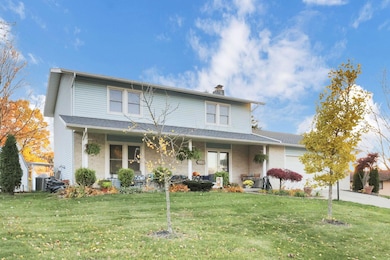
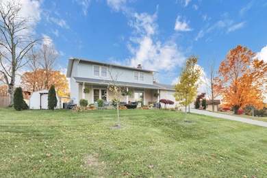
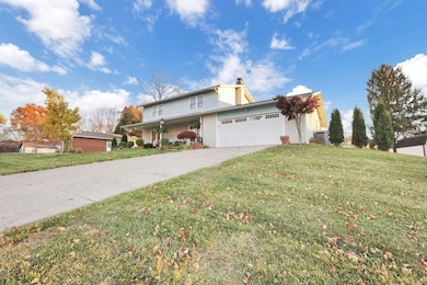
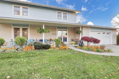
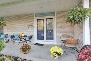
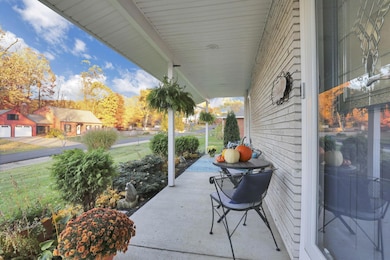
Looking for a house that meets so many needs? Look no further than this well maintained home located in Heath! This house features 5 bedrooms and 4.5 bathrooms in total. One of the bedroom spaces with an attached bath, laundry, and kitchenette for a guest space both long term or short term. The remainder of the 4 bedrooms are upstairs, offering spacious sizes and a primary suite. On the main level you will find 2 living rooms, and updated kitchen, and a large dining room big enough for 2 full size tables. The main floor is also where you will find the guest suite. Open up the double patio doors to a large covered deck overlooking the tree line landscape. The backyard is an entertainers dream. This home also features a front porch, a basement with a second laundry room, space for an additional bedroom, and another family room. This home has so many amazing qualities and can be YOURS!!
Last Agent to Sell the Property
EXP Realty, LLC License #2021000917 Listed on: 11/07/2025

| Date | Type | Sale Price | Title Company |
|---|---|---|---|
| Warranty Deed | $366,900 | Access Title | |
| Interfamily Deed Transfer | -- | None Available | |
| Interfamily Deed Transfer | -- | Attorney | |
| Survivorship Deed | $150,000 | -- |
| Date | Status | Loan Amount | Loan Type |
|---|---|---|---|
| Open | $348,555 | New Conventional | |
| Previous Owner | $137,362 | FHA | |
| Previous Owner | $154,950 | VA |
| Date | Event | Price | List to Sale | Price per Sq Ft |
|---|---|---|---|---|
| 12/18/2025 12/18/25 | Sold | $366,900 | -0.8% | $165 / Sq Ft |
| 11/07/2025 11/07/25 | For Sale | $369,900 | -- | $166 / Sq Ft |
| Year | Tax Paid | Tax Assessment Tax Assessment Total Assessment is a certain percentage of the fair market value that is determined by local assessors to be the total taxable value of land and additions on the property. | Land | Improvement |
|---|---|---|---|---|
| 2024 | $4,302 | $100,000 | $21,950 | $78,050 |
| 2023 | $7,848 | $100,000 | $21,950 | $78,050 |
| 2022 | $3,491 | $64,440 | $12,810 | $51,630 |
| 2021 | $3,562 | $64,440 | $12,810 | $51,630 |
| 2020 | $3,585 | $64,440 | $12,810 | $51,630 |
| 2019 | $3,154 | $57,720 | $12,810 | $44,910 |
| 2018 | $3,188 | $0 | $0 | $0 |
| 2017 | $3,181 | $0 | $0 | $0 |
| 2016 | $3,122 | $0 | $0 | $0 |
| 2015 | $3,175 | $0 | $0 | $0 |
| 2014 | $4,466 | $0 | $0 | $0 |
| 2013 | $2,928 | $0 | $0 | $0 |
J
Seller's Agent in 2025
Jennifer Pettit
EXP Realty, LLC
(740) 641-4047
25 in this area
81 Total Sales
Buyer's Agent in 2025
Mark Kryling
RE/MAX
(740) 975-0028
1 in this area
10 Total Sales
Source: Columbus and Central Ohio Regional MLS
MLS Number: 225042292
APN: 030-091866-00.000
Disclaimer: Certain information contained herein is derived from information provided by parties other than Homes.com. All information provided is deemed reliable, but is not guaranteed to be accurate and should be independently verified.
![]() IDX information is provided exclusively for personal, non-commercial use, and may not be used for any purpose other than to identify prospective properties consumers may be interested in purchasing.
IDX information is provided exclusively for personal, non-commercial use, and may not be used for any purpose other than to identify prospective properties consumers may be interested in purchasing.
Information is deemed reliable but not guaranteed.
Ask me questions while you tour the home.