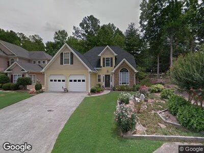
1805 Millstone Ct Alpharetta, GA 30004
Estimated Value: $467,000 - $500,000
3
Beds
3
Baths
1,415
Sq Ft
$345/Sq Ft
Est. Value
About This Home
This home is located at 1805 Millstone Ct, Alpharetta, GA 30004 and is currently estimated at $488,154, approximately $344 per square foot. 1805 Millstone Ct is a home located in Fulton County with nearby schools including Manning Oaks Elementary School, Hopewell Middle School, and Alpharetta High School.
Ownership History
Date
Name
Owned For
Owner Type
Purchase Details
Closed on
Nov 10, 2016
Sold by
Connie Jean
Bought by
Thompson Christopher A and Thompson Connie Jean Irrevoc
Current Estimated Value
Purchase Details
Closed on
Feb 14, 1994
Sold by
Housing Group Inc The
Bought by
Thompson Connie J
Home Financials for this Owner
Home Financials are based on the most recent Mortgage that was taken out on this home.
Original Mortgage
$101,800
Interest Rate
6.96%
Create a Home Valuation Report for This Property
The Home Valuation Report is an in-depth analysis detailing your home's value as well as a comparison with similar homes in the area
Home Values in the Area
Average Home Value in this Area
Purchase History
| Date | Buyer | Sale Price | Title Company |
|---|---|---|---|
| Thompson Christopher A | -- | -- | |
| Thompson Connie J | $127,300 | -- |
Source: Public Records
Mortgage History
| Date | Status | Borrower | Loan Amount |
|---|---|---|---|
| Open | Thompson Christopher A | $200,000 | |
| Previous Owner | Thompson Connie J | $50,000 | |
| Previous Owner | Thompson Connie J | $101,800 |
Source: Public Records
Tax History Compared to Growth
Tax History
| Year | Tax Paid | Tax Assessment Tax Assessment Total Assessment is a certain percentage of the fair market value that is determined by local assessors to be the total taxable value of land and additions on the property. | Land | Improvement |
|---|---|---|---|---|
| 2023 | $4,731 | $167,600 | $40,200 | $127,400 |
| 2022 | $1,104 | $124,720 | $29,600 | $95,120 |
| 2021 | $1,088 | $121,640 | $31,280 | $90,360 |
| 2020 | $1,086 | $113,800 | $28,520 | $85,280 |
| 2019 | $0 | $125,520 | $31,000 | $94,520 |
| 2018 | $2,002 | $122,520 | $30,240 | $92,280 |
| 2017 | $1,056 | $66,920 | $17,360 | $49,560 |
| 2016 | $1,368 | $66,920 | $17,360 | $49,560 |
| 2015 | $1,412 | $66,920 | $17,360 | $49,560 |
| 2014 | $1,409 | $66,920 | $17,360 | $49,560 |
Source: Public Records
Map
Nearby Homes
- 6041 Coventry Cir
- 4025 Lullwater Way
- 2780 Ashleigh Ln
- 1160 Arborhill Ln
- 5051 Brookside Ct
- 3053 Westwood Way Unit 7
- 4086 Whitehall Way
- 1702 Cotton Patch Ln
- 1630 Homestead Trail
- 111 John Christopher Dr
- 2671 Ashleigh Ln
- 151 John Christopher Dr
- 0 John Christopher Dr Unit 7455481
- 385 Jayne Ellen Way
- 175 Jayne Ellen Way
- 124 Sterling Ct
- 228 Water Oak Place
- 136 Sterling Ct
- 1805 Millstone Ct
- 1815 Millstone Ct Unit 2
- 1825 Millstone Ct
- 0 Millstone Ct Unit 7321343
- 0 Millstone Ct Unit 7363523
- 0 Millstone Ct Unit 8798425
- 0 Millstone Ct Unit 8577895
- 0 Millstone Ct Unit 8581836
- 0 Millstone Ct Unit 8654099
- 0 Millstone Ct Unit 3160530
- 0 Millstone Ct
- 1800 Millstone Ct
- 1835 Millstone Ct
- 7030 Trellis Ct
- 7020 Trellis Ct
- 7040 Trellis Ct
- 1810 Millstone Ct
- 7050 Trellis Ct
- 2005 Brookridge Terrace
- 1845 Millstone Ct