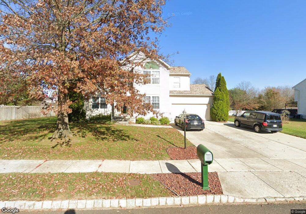
1807 Hessian Dr Williamstown, NJ 08094
Monroe Township Gloucester NeighborhoodEstimated Value: $483,000 - $599,000
--
Bed
--
Bath
3,013
Sq Ft
$181/Sq Ft
Est. Value
About This Home
This home is located at 1807 Hessian Dr, Williamstown, NJ 08094 and is currently estimated at $543,856, approximately $180 per square foot. 1807 Hessian Dr is a home located in Gloucester County with nearby schools including Williamstown High School and St Michael The Archangel Regional School.
Ownership History
Date
Name
Owned For
Owner Type
Purchase Details
Closed on
Oct 30, 1996
Sold by
Signature Homes Inc
Bought by
Campisi Frank J and Campisi Joann E
Current Estimated Value
Home Financials for this Owner
Home Financials are based on the most recent Mortgage that was taken out on this home.
Original Mortgage
$148,450
Outstanding Balance
$14,643
Interest Rate
8.1%
Estimated Equity
$529,213
Create a Home Valuation Report for This Property
The Home Valuation Report is an in-depth analysis detailing your home's value as well as a comparison with similar homes in the area
Home Values in the Area
Average Home Value in this Area
Purchase History
| Date | Buyer | Sale Price | Title Company |
|---|---|---|---|
| Campisi Frank J | $156,315 | Fidelity Title Abstract Co |
Source: Public Records
Mortgage History
| Date | Status | Borrower | Loan Amount |
|---|---|---|---|
| Open | Campisi Frank J | $148,450 |
Source: Public Records
Tax History Compared to Growth
Tax History
| Year | Tax Paid | Tax Assessment Tax Assessment Total Assessment is a certain percentage of the fair market value that is determined by local assessors to be the total taxable value of land and additions on the property. | Land | Improvement |
|---|---|---|---|---|
| 2025 | $10,843 | $296,100 | $57,600 | $238,500 |
| 2024 | $10,763 | $296,100 | $57,600 | $238,500 |
| 2023 | $10,763 | $296,100 | $57,600 | $238,500 |
| 2022 | $10,713 | $296,100 | $57,600 | $238,500 |
| 2021 | $10,781 | $296,100 | $57,600 | $238,500 |
| 2020 | $10,769 | $296,100 | $57,600 | $238,500 |
| 2019 | $10,704 | $296,100 | $57,600 | $238,500 |
| 2018 | $10,529 | $296,100 | $57,600 | $238,500 |
| 2017 | $10,789 | $304,600 | $75,000 | $229,600 |
| 2016 | $10,652 | $304,600 | $75,000 | $229,600 |
| 2015 | $10,347 | $304,600 | $75,000 | $229,600 |
| 2014 | $10,046 | $304,600 | $75,000 | $229,600 |
Source: Public Records
Map
Nearby Homes
- 34 Morgan Dr
- 34 Fisler Dr
- 161 Deschler Blvd
- 109 Holly Rd
- 100 Stage Coach Rd
- 201 Luray Dr
- 271 Kille Rd
- 2020 Paddock Ln
- 1201 Whispering Woods Dr
- 960 Butler Dr
- 613 Cedar Ave
- Cadence Plan at Blaze Mill
- Ballad Plan at Blaze Mill
- Aria Plan at Blaze Mill
- 23 Turnberry Dr
- 7 Augusta Ct
- 664 Scotland Run Ave
- 366 N Tuckahoe Rd
- 179 Presley Way
- 741 N Tuckahoe Rd
- 1805 Hessian Dr
- 1809 Hessian Dr
- 1312 Heidelberg Dr
- 1310 Heidelberg Dr
- 1314 Heidelberg Dr
- 1810 Hessian Dr
- 1808 Hessian Dr
- 1803 Hessian Dr
- 1308 Heidelberg Dr
- 1316 Heidelberg Dr
- 1812 Hessian Dr
- 1806 Hessian Dr
- 1814 Hessian Dr
- 1318 Heidelberg Dr
- 1801 Hessian Dr
- 1804 Hessian Dr
- 1306 Heidelberg Dr
- 137 Deschler Blvd
- 100 Kaiser Ln
- 135 Deschler Blvd