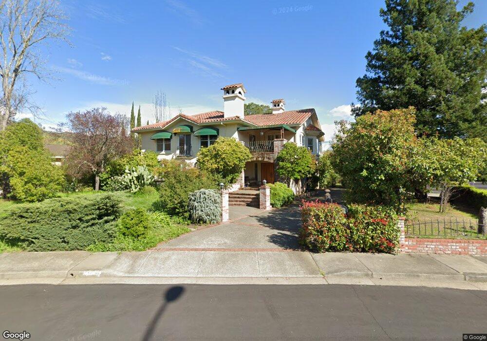
1808 Michael Way Calistoga, CA 94515
Estimated Value: $1,340,000 - $2,232,932
3
Beds
4
Baths
2,967
Sq Ft
$559/Sq Ft
Est. Value
About This Home
This home is located at 1808 Michael Way, Calistoga, CA 94515 and is currently estimated at $1,658,483, approximately $558 per square foot. 1808 Michael Way is a home located in Napa County with nearby schools including Calistoga Elementary School and Calistoga Junior/Senior High School.
Ownership History
Date
Name
Owned For
Owner Type
Purchase Details
Closed on
Dec 6, 2024
Sold by
Nicholson Margaret A
Bought by
Margaret A Nicholson 2024 Trust and Nicholson
Current Estimated Value
Purchase Details
Closed on
Mar 10, 2006
Sold by
Benko William G and Benko Marjorie E
Bought by
Nicholson Margaret A
Home Financials for this Owner
Home Financials are based on the most recent Mortgage that was taken out on this home.
Original Mortgage
$772,000
Interest Rate
7%
Mortgage Type
Purchase Money Mortgage
Create a Home Valuation Report for This Property
The Home Valuation Report is an in-depth analysis detailing your home's value as well as a comparison with similar homes in the area
Home Values in the Area
Average Home Value in this Area
Purchase History
We collect this data history from publicly available records. To have your information removed, we recommend requesting removal directly through your county’s website.
| Date | Buyer | Sale Price | Title Company |
|---|---|---|---|
| Margaret A Nicholson 2024 Trust | -- | None Listed On Document | |
| Nicholson Margaret A | $965,000 | Fidelity National Title Co |
Source: Public Records
Mortgage History
We collect this data history from publicly available records. To have your information removed, we recommend requesting removal directly through your county’s website.
| Date | Status | Borrower | Loan Amount |
|---|---|---|---|
| Previous Owner | Nicholson Margaret A | $772,000 |
Source: Public Records
Tax History
| Year | Tax Paid | Tax Assessment Tax Assessment Total Assessment is a certain percentage of the fair market value that is determined by local assessors to be the total taxable value of land and additions on the property. | Land | Improvement |
|---|---|---|---|---|
| 2025 | $14,339 | $1,318,743 | $546,629 | $772,114 |
| 2024 | $14,097 | $1,292,886 | $535,911 | $756,975 |
| 2023 | $14,097 | $1,267,536 | $525,403 | $742,133 |
| 2022 | $13,217 | $1,242,683 | $515,101 | $727,582 |
| 2021 | $12,810 | $1,218,317 | $505,001 | $713,316 |
| 2020 | $12,672 | $1,205,825 | $499,823 | $706,002 |
| 2019 | $12,512 | $1,182,182 | $490,023 | $692,159 |
| 2018 | $11,397 | $1,069,000 | $444,000 | $625,000 |
| 2017 | $9,120 | $855,000 | $355,000 | $500,000 |
| 2016 | $8,502 | $801,127 | $331,550 | $469,577 |
| 2015 | $7,759 | $728,297 | $301,409 | $426,888 |
| 2014 | $6,953 | $650,265 | $269,115 | $381,150 |
Source: Public Records
Map
Nearby Homes
- 1759 Emerald Dr
- 3004 Money Ln
- 1710 Reynard Ln
- 1701 N Oak St
- 4025 Lake County Hwy
- 1929 Mora Ave
- 34 View Rd
- 1422 N Oak St
- 1438 Grant St
- 1559 Silverado Terrace Loop
- 1551 Silverado Terrace Loop
- 1557 Silverado Terrace Loop Unit 37
- 1553 Silverado Terrace Loop Unit 35
- 1553 Silverado Terrace Loop
- 1559 Silverado Terrace Loop Unit 38
- 1431 4th St
- 1231 Stevenson St
- 33 Brannan St
- 1429 3rd St
- 1411 4th St
- 1800 Michael Way
- 1812 Michael Way
- 1718 Michael Way
- 1903 Emerald Dr
- 1901 Emerald Dr
- 1905 Emerald Dr
- 1779 Emerald Dr
- 1907 Emerald Dr
- 1801 Michael Way
- 2001 Money Ln
- 1769 Emerald Dr
- 1909 Emerald Dr
- 1719 Michael Way
- 2011 Money Ln
- 1774 Emerald Dr
- 1809 Michael Way
- 1801 Aurora Dr
- 1904 Emerald Dr
- 1717 Michael Way
- 1906 Emerald Dr
Your Personal Tour Guide
Ask me questions while you tour the home.