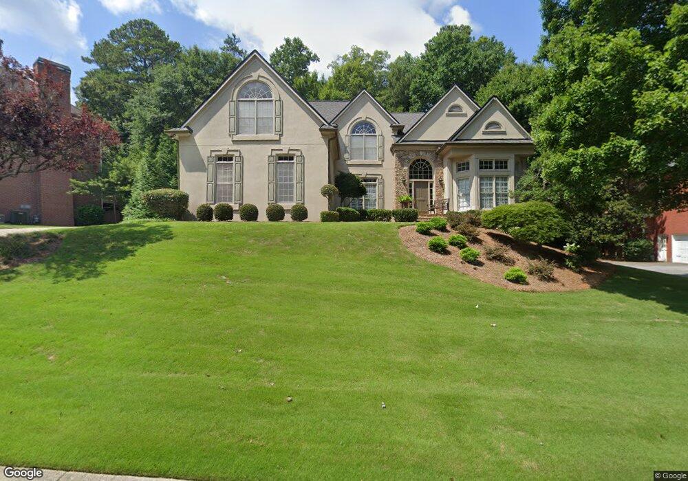
1809 Pemberton Place Marietta, GA 30062
East Cobb NeighborhoodEstimated Value: $1,047,333 - $1,228,000
4
Beds
4
Baths
3,770
Sq Ft
$297/Sq Ft
Est. Value
About This Home
This home is located at 1809 Pemberton Place, Marietta, GA 30062 and is currently estimated at $1,119,583, approximately $296 per square foot. 1809 Pemberton Place is a home located in Cobb County with nearby schools including Mount Bethel Elementary School, Dodgen Middle School, and Walton High School.
Ownership History
Date
Name
Owned For
Owner Type
Purchase Details
Closed on
Sep 18, 1995
Sold by
John Wieland Homes
Bought by
Heifner Steven E Amy
Current Estimated Value
Create a Home Valuation Report for This Property
The Home Valuation Report is an in-depth analysis detailing your home's value as well as a comparison with similar homes in the area
Home Values in the Area
Average Home Value in this Area
Purchase History
| Date | Buyer | Sale Price | Title Company |
|---|---|---|---|
| Heifner Steven E Amy | $356,000 | -- |
Source: Public Records
Mortgage History
| Date | Status | Borrower | Loan Amount |
|---|---|---|---|
| Closed | Heifner Steven E Amy | $0 |
Source: Public Records
Tax History Compared to Growth
Tax History
| Year | Tax Paid | Tax Assessment Tax Assessment Total Assessment is a certain percentage of the fair market value that is determined by local assessors to be the total taxable value of land and additions on the property. | Land | Improvement |
|---|---|---|---|---|
| 2025 | $2,288 | $334,352 | $90,000 | $244,352 |
| 2024 | $2,295 | $334,352 | $90,000 | $244,352 |
| 2023 | $2,089 | $334,352 | $90,000 | $244,352 |
| 2022 | $2,130 | $279,156 | $82,000 | $197,156 |
| 2021 | $2,129 | $278,908 | $84,000 | $194,908 |
| 2020 | $2,129 | $278,908 | $84,000 | $194,908 |
| 2019 | $2,129 | $278,908 | $84,000 | $194,908 |
| 2018 | $2,129 | $278,908 | $84,000 | $194,908 |
| 2017 | $1,824 | $255,412 | $72,000 | $183,412 |
| 2016 | $1,694 | $211,284 | $72,000 | $139,284 |
| 2015 | $1,817 | $211,284 | $72,000 | $139,284 |
| 2014 | $1,858 | $211,284 | $0 | $0 |
Source: Public Records
Map
Nearby Homes
- 2082 Kinsmon Dr
- 4599 Lasalle Ct Unit 8A
- 4780 Waterhaven Bend
- 4789 Waterhaven Bend
- 4804 Dalhousie Place NE
- 2100 Stone Hollow Ct
- 4580 Roswell Rd
- 1961 Fields Pond Dr
- 4871 Karls Gate Dr
- 2281 Fox Hound Pkwy
- 1804 Shelburne Ridge
- 4586 Hunting Hound Ln
- 4255 Green Ridge Dr
- 1929 Fields Pond Glen
- 2269 Chimney Springs Dr
- 5122 Timber Ridge Rd
- 2066 Old Forge Way
- 1805 Pemberton Place
- 1813 Pemberton Place Unit 2
- 2004 Winsted Way
- 2008 Winsted Way
- 1810 Pemberton Place
- 1801 Pemberton Place Unit 2
- 1808 Pemberton Place
- 1812 Pemberton Place
- 0 Pemberton Place Unit 8370438
- 0 Pemberton Place Unit 8855026
- 0 Pemberton Place Unit 8756904
- 0 Pemberton Place Unit 8608139
- 1816 Pemberton Place Unit 2
- 2012 Winsted Way Unit 2
- 1817 Pemberton Place Unit 2
- 2000 Winsted Way
- 1800 Pemberton Place
- 1804 Pemberton Place
- 2016 Winsted Way
- 1820 Pemberton Place