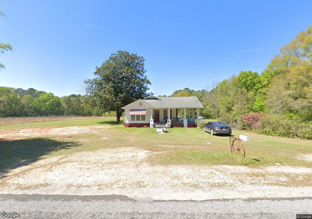
181 Carson-Bunkerhill Rd Carson, MS 39427
Estimated Value: $67,000 - $128,889
2
Beds
1
Bath
1,390
Sq Ft
$69/Sq Ft
Est. Value
About This Home
This home is located at 181 Carson-Bunkerhill Rd, Carson, MS 39427 and is currently estimated at $96,222, approximately $69 per square foot. 181 Carson-Bunkerhill Rd is a home located in Jefferson Davis County with nearby schools including G. W. Carver Elementary School and Bassfield High School.
Ownership History
Date
Name
Owned For
Owner Type
Purchase Details
Closed on
Mar 23, 2009
Sold by
Federal Home Loan Mortgage Corporation
Bought by
King Keith Edward
Current Estimated Value
Purchase Details
Closed on
Apr 4, 2006
Sold by
Purvis Jeremy R
Bought by
Smith Rolan Max
Home Financials for this Owner
Home Financials are based on the most recent Mortgage that was taken out on this home.
Original Mortgage
$52,000
Interest Rate
6.2%
Mortgage Type
Purchase Money Mortgage
Create a Home Valuation Report for This Property
The Home Valuation Report is an in-depth analysis detailing your home's value as well as a comparison with similar homes in the area
Purchase History
| Date | Buyer | Sale Price | Title Company |
|---|---|---|---|
| King Keith Edward | $26,500 | -- | |
| Smith Rolan Max | -- | -- |
Source: Public Records
Mortgage History
| Date | Status | Borrower | Loan Amount |
|---|---|---|---|
| Previous Owner | Smith Rolan Max | $52,000 |
Source: Public Records
Tax History
| Year | Tax Paid | Tax Assessment Tax Assessment Total Assessment is a certain percentage of the fair market value that is determined by local assessors to be the total taxable value of land and additions on the property. | Land | Improvement |
|---|---|---|---|---|
| 2025 | $666 | $6,450 | $0 | $0 |
| 2024 | $666 | $6,450 | $0 | $0 |
| 2023 | $543 | $5,620 | $0 | $0 |
| 2022 | $421 | $4,376 | $0 | $0 |
| 2021 | $827 | $6,349 | $0 | $0 |
| 2020 | $827 | $6,349 | $0 | $0 |
| 2019 | $806 | $6,349 | $0 | $0 |
| 2018 | $827 | $6,253 | $0 | $0 |
| 2017 | $812 | $6,253 | $0 | $0 |
| 2016 | $386 | $4,312 | $0 | $0 |
| 2015 | $334 | $4,312 | $0 | $0 |
| 2014 | $334 | $4,051 | $0 | $0 |
| 2013 | $334 | $4,051 | $0 | $0 |
Source: Public Records
Map
Nearby Homes
- 0 Dyess Rd Unit 4139790
- D A Dyess Rd
- 0 Graves Rd
- 1334 Greens Creek Rd
- Wiley Dyess Rd
- Lot 3 Sinclair Rd
- Lot 4 Sinclair Rd
- Lot 2 Sinclair Rd
- Lot 5 Sinclair Rd
- Lot 6 Ebenezer Rd
- Lot 1 Sinclair Rd-Ms-35
- 86 Haddox Rd
- 192 F McNeese Rd
- 00 Grice Rd
- 0 Grice Rd
- 186 Friendship Rd
- Greens Creek Rd Unit LotWP001
- Greens Creek Rd Unit LotWP002
- 7585 Mississippi 35
- 00 Miller Rd
- 157 Carson Bunker Hill Rd
- 121 Carson Bunker Hill Rd
- 157 Carson Bunker Hill Rd
- 181 Carson Bunker Hill Rd
- 202 Carson Bunker Hill Rd
- 66 Carson Bunker Hill Rd
- 66 Carson Bunker Hill Rd
- 120 Carson Bunker Hill Rd
- 120 Carson Bunker Hill Rd
- 178 Carson Bunker Hill Rd
- 24 Speights Rd
- 172 Short Chapel Loop
- 198 Short Chapel Loop
- 263 Carson Bunker Hill Rd
- 184 Graves Rd
- 63 Speights Rd
- 94 D A Dyess Rd
- 268 Carson Bunker Hill Rd
- 72 Bass Burkett Rd
- 0 D A Dyess Rd
Your Personal Tour Guide
Ask me questions while you tour the home.