Estimated Value: $370,000 - $407,000
3
Beds
3
Baths
1,800
Sq Ft
$213/Sq Ft
Est. Value
About This Home
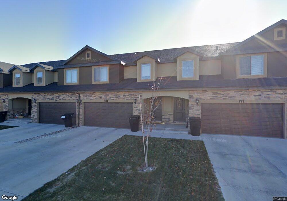
This home is located at 181 E 560 N Unit 21, Salem, UT 84653 and is currently estimated at $383,192, approximately $212 per square foot. 181 E 560 N Unit 21 is a home located in Utah County with nearby schools including Salem Elementary, Salem Junior High School, and Valley View Middle School.
Ownership History
Date
Name
Owned For
Owner Type
Purchase Details
Closed on
Jun 9, 2017
Sold by
Wilson Michael A and Wilson Susan C
Bought by
Wilson Michael A and Wilson Susan C
Current Estimated Value
Purchase Details
Closed on
Aug 18, 2015
Sold by
Salem Townhomes Llc
Bought by
Wilson Michael A and Wilson Susan C
Home Financials for this Owner
Home Financials are based on the most recent Mortgage that was taken out on this home.
Original Mortgage
$90,000
Outstanding Balance
$70,833
Interest Rate
4.05%
Mortgage Type
New Conventional
Estimated Equity
$312,359
Purchase Details
Closed on
Jul 29, 2015
Sold by
Smiley John D
Bought by
Salem Townhomes Llc
Home Financials for this Owner
Home Financials are based on the most recent Mortgage that was taken out on this home.
Original Mortgage
$90,000
Outstanding Balance
$70,833
Interest Rate
4.05%
Mortgage Type
New Conventional
Estimated Equity
$312,359
Create a Home Valuation Report for This Property
The Home Valuation Report is an in-depth analysis detailing your home's value as well as a comparison with similar homes in the area
Home Values in the Area
Average Home Value in this Area
Purchase History
| Date | Buyer | Sale Price | Title Company |
|---|---|---|---|
| Wilson Michael A | -- | Accommodation | |
| Wilson Michael A | -- | Wasatch Land & Title | |
| Salem Townhomes Llc | -- | Wasatch Land & Title |
Source: Public Records
Mortgage History
| Date | Status | Borrower | Loan Amount |
|---|---|---|---|
| Open | Wilson Michael A | $90,000 |
Source: Public Records
Tax History
| Year | Tax Paid | Tax Assessment Tax Assessment Total Assessment is a certain percentage of the fair market value that is determined by local assessors to be the total taxable value of land and additions on the property. | Land | Improvement |
|---|---|---|---|---|
| 2025 | $1,935 | $195,855 | -- | -- |
| 2024 | $1,935 | $196,240 | $0 | $0 |
| 2023 | $1,877 | $190,685 | $0 | $0 |
| 2022 | $2,054 | $205,425 | $0 | $0 |
| 2021 | $1,750 | $280,800 | $42,100 | $238,700 |
| 2020 | $1,625 | $253,800 | $38,100 | $215,700 |
| 2019 | $1,557 | $248,400 | $32,300 | $216,100 |
| 2018 | $1,476 | $225,000 | $28,000 | $197,000 |
| 2017 | $1,347 | $109,505 | $0 | $0 |
| 2016 | $1,239 | $99,550 | $0 | $0 |
Source: Public Records
Map
Nearby Homes
- 191 E 560 N
- 625 N 220 E
- 685-1197 N 1850 E
- 689-1198 N 1850 E
- 685 N 220 E
- 703 N 150 E
- 708 N 220 E
- 1223 N 360 E Unit 129
- 1212 N 360 E Unit 132
- 1195 N 360 E Unit 127
- 1241 N 360 E Unit 130
- 1238 N 360 E Unit 133
- 1207 N 360 E Unit 128
- 596 N 360 E
- 1165 N 360 E Unit 75
- 1176 N 250 E Unit 71
- 16 W 650 N Unit 1
- 637 N 400 E
- 741 S State Rd Unit 14
- 673 410 E
Your Personal Tour Guide
Ask me questions while you tour the home.