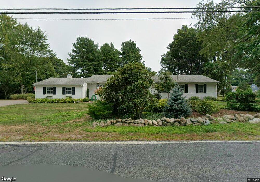
1810 West St Mansfield, MA 02048
Estimated Value: $631,000 - $750,000
4
Beds
3
Baths
1,828
Sq Ft
$379/Sq Ft
Est. Value
About This Home
This home is located at 1810 West St, Mansfield, MA 02048 and is currently estimated at $691,983, approximately $378 per square foot. 1810 West St is a home located in Bristol County with nearby schools including Everett W. Robinson Elementary School, Jordan/Jackson Elementary School, and Harold L. Qualters Middle School.
Ownership History
Date
Name
Owned For
Owner Type
Purchase Details
Closed on
Mar 30, 2016
Sold by
Holt Kerry A and Beattie Kristine S
Bought by
1810 West Street Nt
Current Estimated Value
Purchase Details
Closed on
Oct 9, 2015
Sold by
Mcgrath Cheryl A
Bought by
Beattie Kristine S and Mcgrath Keith D
Purchase Details
Closed on
Jun 24, 2004
Sold by
Richendollar Nancy J
Bought by
Mcgrath Cheryl A
Home Financials for this Owner
Home Financials are based on the most recent Mortgage that was taken out on this home.
Original Mortgage
$135,000
Interest Rate
6.32%
Mortgage Type
Purchase Money Mortgage
Create a Home Valuation Report for This Property
The Home Valuation Report is an in-depth analysis detailing your home's value as well as a comparison with similar homes in the area
Home Values in the Area
Average Home Value in this Area
Purchase History
| Date | Buyer | Sale Price | Title Company |
|---|---|---|---|
| 1810 West Street Nt | -- | -- | |
| Beattie Kristine S | -- | -- | |
| Mcgrath Cheryl A | $405,000 | -- |
Source: Public Records
Mortgage History
| Date | Status | Borrower | Loan Amount |
|---|---|---|---|
| Previous Owner | Mcgrath Cheryl A | $135,000 |
Source: Public Records
Tax History Compared to Growth
Tax History
| Year | Tax Paid | Tax Assessment Tax Assessment Total Assessment is a certain percentage of the fair market value that is determined by local assessors to be the total taxable value of land and additions on the property. | Land | Improvement |
|---|---|---|---|---|
| 2025 | $7,237 | $549,500 | $237,800 | $311,700 |
| 2024 | $6,604 | $489,200 | $237,800 | $251,400 |
| 2023 | $6,445 | $457,400 | $237,800 | $219,600 |
| 2022 | $6,229 | $410,600 | $220,100 | $190,500 |
| 2021 | $5,771 | $397,200 | $192,700 | $204,500 |
| 2020 | $5,842 | $382,000 | $183,500 | $198,500 |
| 2019 | $5,501 | $361,400 | $152,800 | $208,600 |
| 2018 | $5,834 | $330,100 | $145,700 | $184,400 |
| 2017 | $5,047 | $336,000 | $141,500 | $194,500 |
| 2016 | $5,053 | $327,900 | $134,700 | $193,200 |
| 2015 | $4,600 | $296,800 | $134,700 | $162,100 |
Source: Public Records
Map
Nearby Homes
- 47 Old Farm Rd
- 17 Peters Way
- 36 Cranberry Rd
- 150 Gilbert St
- 11 Landry Ave
- 10 Sleepy Hollow Cir
- 6 Colts Way
- 115 Westfield Dr
- 14 Claire Ave
- 16 Raymond Hall Dr
- 4 Buckskin Dr
- 57 Vine St
- 116 George St
- 15 Old Wood Rd
- 451R Gilbert St
- Lot 5 Jeffrey Dr
- Lot 2 Jeffrey Dr
- 176 Elm St
- 6 Cedar Creek Dr
- 546 Towne St