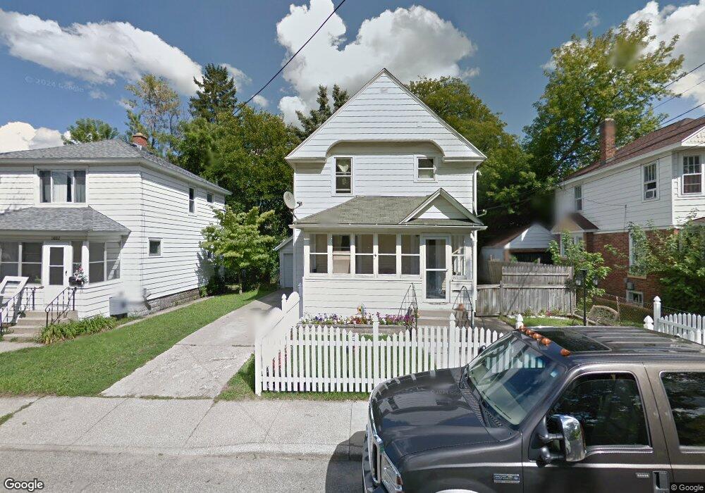
1811 James St Kalamazoo, MI 49001
Edison NeighborhoodEstimated Value: $118,000 - $140,000
3
Beds
1
Bath
1,262
Sq Ft
$103/Sq Ft
Est. Value
About This Home
This home is located at 1811 James St, Kalamazoo, MI 49001 and is currently estimated at $129,463, approximately $102 per square foot. 1811 James St is a home located in Kalamazoo County with nearby schools including Milwood Elementary School, Milwood Magnet School, and Loy Norrix High School.
Ownership History
Date
Name
Owned For
Owner Type
Purchase Details
Closed on
Dec 9, 2022
Sold by
Castaneda-Rojo Ismael
Bought by
Castaneda-Rojo Dario and Vasquez Diana Lucia
Current Estimated Value
Purchase Details
Closed on
Sep 1, 2017
Sold by
Castaneda Rojo Ismael
Bought by
Rodriguez Castaneda Rojo Dario and Rodriguez Vazquez Diana Lucia
Purchase Details
Closed on
Jan 30, 2013
Sold by
Castaneda Jamie
Bought by
Castaneda Ismael
Purchase Details
Closed on
Oct 18, 2010
Sold by
Nationstar Mortgage Llc
Bought by
Federal National Mortgage Association
Purchase Details
Closed on
Aug 12, 2010
Sold by
Labon Cynthia
Bought by
Nationstar Mortgage Llc
Create a Home Valuation Report for This Property
The Home Valuation Report is an in-depth analysis detailing your home's value as well as a comparison with similar homes in the area
Home Values in the Area
Average Home Value in this Area
Purchase History
| Date | Buyer | Sale Price | Title Company |
|---|---|---|---|
| Castaneda-Rojo Dario | $50,000 | None Listed On Document | |
| Rodriguez Castaneda Rojo Dario | -- | Attorney | |
| Castaneda Ismael | -- | None Available | |
| Federal National Mortgage Association | -- | None Available | |
| Nationstar Mortgage Llc | $88,437 | None Available |
Source: Public Records
Tax History Compared to Growth
Tax History
| Year | Tax Paid | Tax Assessment Tax Assessment Total Assessment is a certain percentage of the fair market value that is determined by local assessors to be the total taxable value of land and additions on the property. | Land | Improvement |
|---|---|---|---|---|
| 2025 | $1,208 | $55,900 | $0 | $0 |
| 2024 | $675 | $44,400 | $0 | $0 |
| 2023 | $643 | $39,400 | $0 | $0 |
| 2022 | $1,096 | $33,400 | $0 | $0 |
| 2021 | $1,059 | $31,900 | $0 | $0 |
| 2020 | $1,037 | $28,000 | $0 | $0 |
| 2019 | $989 | $22,800 | $0 | $0 |
| 2018 | $966 | $20,600 | $0 | $0 |
| 2017 | $1,330 | $21,000 | $0 | $0 |
| 2016 | $1,330 | $20,600 | $0 | $0 |
| 2015 | $1,330 | $20,300 | $0 | $0 |
| 2014 | $1,330 | $18,600 | $0 | $0 |
Source: Public Records
Map
Nearby Homes
- 1028 Clinton Ave
- 1224 Lane Blvd
- 1424 Lay Blvd
- 1939 March St
- 915 Hays Park Ave
- 1512 Race St
- 1002 Egleston Ave
- 1118 E Alcott St
- 1303 E Stockbridge Ave
- 1803 Portage St
- 923 E Stockbridge Ave
- 1212 Washington Ave
- 117 E Stockbridge Ave
- 1517 E Stockbridge Ave
- 1510 Palmer Ave
- 920 Washington Ave
- 916 Washington Ave
- 1211 James St
- 1336 Portage St
- 1517 Fair St