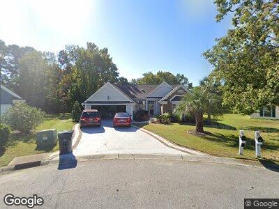
1811 Wexford Ct Myrtle Beach, SC 29575
Estimated Value: $395,635 - $443,000
3
Beds
2
Baths
2,210
Sq Ft
$191/Sq Ft
Est. Value
About This Home
This home is located at 1811 Wexford Ct, Myrtle Beach, SC 29575 and is currently estimated at $421,909, approximately $190 per square foot. 1811 Wexford Ct is a home located in Horry County with nearby schools including Lakewood Elementary, Socastee Middle, and Socastee High School.
Ownership History
Date
Name
Owned For
Owner Type
Purchase Details
Closed on
Mar 1, 2007
Sold by
Condrey Glenwood P and Condrey Ellen S
Bought by
Rowland Robert F and Rowland Patricia J
Current Estimated Value
Home Financials for this Owner
Home Financials are based on the most recent Mortgage that was taken out on this home.
Original Mortgage
$268,000
Interest Rate
6.3%
Mortgage Type
Purchase Money Mortgage
Purchase Details
Closed on
Aug 19, 2003
Sold by
Bridges Audrey R and Pope Vickie P
Bought by
Bridges Audrey R
Purchase Details
Closed on
Jun 26, 2003
Sold by
Bridges Audrey R
Bought by
Bridges Audrey R and Pope Vickie P
Purchase Details
Closed on
Jan 20, 1999
Sold by
Bridges Arthur O
Bought by
Bridges Audrey R
Create a Home Valuation Report for This Property
The Home Valuation Report is an in-depth analysis detailing your home's value as well as a comparison with similar homes in the area
Home Values in the Area
Average Home Value in this Area
Purchase History
| Date | Buyer | Sale Price | Title Company |
|---|---|---|---|
| Rowland Robert F | $335,000 | None Available | |
| Bridges Audrey R | -- | -- | |
| Bridges Audrey R | -- | -- | |
| Bridges Audrey R | $147,700 | -- |
Source: Public Records
Mortgage History
| Date | Status | Borrower | Loan Amount |
|---|---|---|---|
| Open | Rowland Robert F | $175,000 | |
| Closed | Rowland Robert F | $268,000 |
Source: Public Records
Tax History Compared to Growth
Tax History
| Year | Tax Paid | Tax Assessment Tax Assessment Total Assessment is a certain percentage of the fair market value that is determined by local assessors to be the total taxable value of land and additions on the property. | Land | Improvement |
|---|---|---|---|---|
| 2024 | $944 | $8,086 | $2,410 | $5,676 |
| 2023 | $944 | $8,086 | $2,410 | $5,676 |
| 2021 | $855 | $8,086 | $2,410 | $5,676 |
| 2020 | $748 | $8,086 | $2,410 | $5,676 |
| 2019 | $748 | $8,086 | $2,410 | $5,676 |
| 2018 | $802 | $8,446 | $2,410 | $6,036 |
| 2017 | $787 | $8,446 | $2,410 | $6,036 |
| 2016 | -- | $8,446 | $2,410 | $6,036 |
| 2015 | $787 | $8,447 | $2,411 | $6,036 |
| 2014 | $2,633 | $8,447 | $2,411 | $6,036 |
Source: Public Records
Map
Nearby Homes
- 1886 Southwood Dr
- 1673 Coventry Rd
- 1646 Bay Tree Ln
- 1579 Southwood Dr
- 1600 Gibson Ave
- 383 Mikita Dr
- 534 Pacific Commons Dr
- 510 Pacific Commons Dr
- 504 Pacific Commons Dr
- 1917 Candy Ln Unit MB
- 1769 Crooked Pine Dr
- 1625 Deer Park Ln
- 1849 Crooked Pine Dr Unit C-5
- 1435 Southwood Dr
- 2017 N Berwick Dr
- 1861 Crooked Pine Dr Unit A5
- 567 Hickman St
- 1463 Gibson Ave
- 1490 Turkey Ridge Rd Unit 12-B
- 2150 N Berwick Dr
- 1811 Wexford Ct
- 1815 Wexford Ct
- 1810 Wexford Ct
- 1819 Wexford Ct
- 1931 Kate Ln
- 1814 Wexford Ct
- 1818 Wexford Ct
- 1824 Southwood Dr
- 1824 Southwood Dr
- 1930 Kate Ln
- 1698 Pennystone Trail
- 1838 Southwood Dr
- 1699 Pennystone Trail
- 1927 Kate Ln
- 1842 Southwood Dr
- 1816 Southwood Dr
- 1694 Pennystone Trail
- 1695 Pennystone Trail
- 1854 Southwood Dr
- 1926 Kate Ln