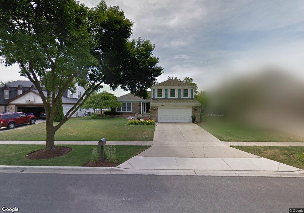
1814 Scottdale Cir Wheaton, IL 60189
Estimated Value: $512,465 - $607,000
3
Beds
3
Baths
2,239
Sq Ft
$257/Sq Ft
Est. Value
About This Home
This home is located at 1814 Scottdale Cir, Wheaton, IL 60189 and is currently estimated at $576,116, approximately $257 per square foot. 1814 Scottdale Cir is a home located in DuPage County with nearby schools including Arbor View Elementary School, Glen Crest Middle School, and Glenbard South High School.
Ownership History
Date
Name
Owned For
Owner Type
Purchase Details
Closed on
Feb 22, 2022
Sold by
Scala and Maryann
Bought by
Scala Andrew and Scala Maryann
Current Estimated Value
Purchase Details
Closed on
May 13, 2016
Sold by
Scala Andrew and Scala Maryann
Bought by
Chicago Title Land Trust Company and Trust #940295
Purchase Details
Closed on
Dec 31, 2015
Sold by
Chicago Title Land Trust Company
Bought by
Scala Andrew and Scala Maryann
Create a Home Valuation Report for This Property
The Home Valuation Report is an in-depth analysis detailing your home's value as well as a comparison with similar homes in the area
Home Values in the Area
Average Home Value in this Area
Purchase History
| Date | Buyer | Sale Price | Title Company |
|---|---|---|---|
| Scala Andrew | -- | None Listed On Document | |
| Chicago Title Land Trust Company | -- | Chicago Title Land Trust Co | |
| Scala Andrew | -- | Carrington Title Partners Ll |
Source: Public Records
Tax History
| Year | Tax Paid | Tax Assessment Tax Assessment Total Assessment is a certain percentage of the fair market value that is determined by local assessors to be the total taxable value of land and additions on the property. | Land | Improvement |
|---|---|---|---|---|
| 2024 | $9,677 | $144,100 | $36,970 | $107,130 |
| 2023 | $9,187 | $132,640 | $34,030 | $98,610 |
| 2022 | $9,005 | $125,350 | $32,160 | $93,190 |
| 2021 | $8,997 | $122,380 | $31,400 | $90,980 |
| 2020 | $9,080 | $121,240 | $31,110 | $90,130 |
| 2019 | $8,833 | $118,040 | $30,290 | $87,750 |
| 2018 | $9,150 | $120,550 | $28,540 | $92,010 |
| 2017 | $8,502 | $116,110 | $27,490 | $88,620 |
| 2016 | $8,357 | $111,470 | $26,390 | $85,080 |
| 2015 | $8,274 | $106,350 | $25,180 | $81,170 |
| 2014 | $7,764 | $99,090 | $22,010 | $77,080 |
| 2013 | $7,531 | $99,390 | $22,080 | $77,310 |
Source: Public Records
Map
Nearby Homes
- 23W070 Mulberry Ln
- 1580 College Ln S
- 1265 Windsor Dr
- 3S481 Osage Dr
- 2S744 Lakeside Dr Unit 21
- 1720 Lakecliffe Dr Unit A
- 1705 Lakecliffe Dr Unit D
- 1733 Harrow Ct Unit B
- 2266 Pebble Creek Dr
- 1927 Warrenville Rd
- 1180 Mount Vernon Ct Unit C
- 1135 Mount Vernon Ct Unit B
- 1120 Mount Vernon Ct Unit C
- 1016 Middleton Place Unit 1016
- 448 Raintree Ct Unit 1C
- 453 Raintree Dr Unit 5A
- 453 Raintree Dr Unit 1H
- 470 Fawell Blvd Unit 510
- 429 Sandhurst Cir Unit 1
- 2019 Middleton Ave
- 1804 Scottdale Cir
- 1836 Scottdale Cir
- 1784 Scottdale Cir
- 1815 Jasper Ct
- 1805 Jasper Ct
- 2241 Stirrup Ln
- 1735 Jasper Ct
- 1770 Scottdale Cir
- 2262 Albright Ln
- 2266 Albright Ln
- 1825 Jasper Ct
- 2272 Albright Ln
- 2242 Stirrup Ln
- 2235 Stirrup Ln
- 1725 Jasper Ct
- 1752 Scottdale Cir
- 2276 Albright Ln
- 1715 Jasper Ct
- 2236 Stirrup Ln Unit 4B
- 1820 Jasper Ct
Your Personal Tour Guide
Ask me questions while you tour the home.