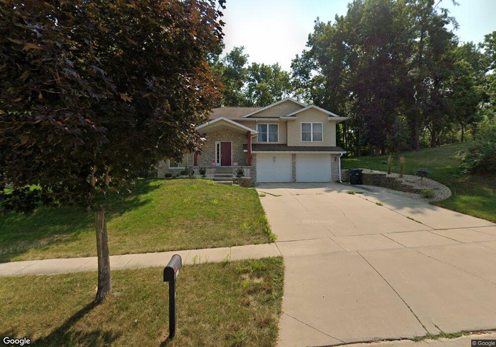
1817 Aaron Dr NW Cedar Rapids, IA 52405
Estimated Value: $359,232 - $410,000
4
Beds
3
Baths
2,584
Sq Ft
$147/Sq Ft
Est. Value
About This Home
This home is located at 1817 Aaron Dr NW, Cedar Rapids, IA 52405 and is currently estimated at $378,808, approximately $146 per square foot. 1817 Aaron Dr NW is a home located in Linn County with nearby schools including Maple Grove Elementary School, North Middletown Elementary School, and Ponderosa Elementary School.
Ownership History
Date
Name
Owned For
Owner Type
Purchase Details
Closed on
Oct 10, 2011
Sold by
Koch Kenneth L and Koch Maridith A
Bought by
White Ben S and White Melissa M
Current Estimated Value
Home Financials for this Owner
Home Financials are based on the most recent Mortgage that was taken out on this home.
Original Mortgage
$176,000
Outstanding Balance
$120,155
Interest Rate
4.12%
Mortgage Type
New Conventional
Estimated Equity
$258,653
Purchase Details
Closed on
Jun 28, 2010
Sold by
Wilmar Development Co
Bought by
Powers Carl C and Powers Anne E
Purchase Details
Closed on
Oct 6, 2009
Sold by
Johnson Dean L and Johnson Jill T
Bought by
Linn Area Credit Union
Create a Home Valuation Report for This Property
The Home Valuation Report is an in-depth analysis detailing your home's value as well as a comparison with similar homes in the area
Home Values in the Area
Average Home Value in this Area
Purchase History
| Date | Buyer | Sale Price | Title Company |
|---|---|---|---|
| White Ben S | $227,000 | None Available | |
| Powers Carl C | $14,500 | None Available | |
| Linn Area Credit Union | $260,000 | None Available |
Source: Public Records
Mortgage History
| Date | Status | Borrower | Loan Amount |
|---|---|---|---|
| Open | White Ben S | $176,000 |
Source: Public Records
Tax History Compared to Growth
Tax History
| Year | Tax Paid | Tax Assessment Tax Assessment Total Assessment is a certain percentage of the fair market value that is determined by local assessors to be the total taxable value of land and additions on the property. | Land | Improvement |
|---|---|---|---|---|
| 2025 | $5,014 | $322,800 | $66,100 | $256,700 |
| 2024 | $5,442 | $304,700 | $58,300 | $246,400 |
| 2023 | $5,442 | $293,800 | $58,300 | $235,500 |
| 2022 | $4,832 | $266,900 | $50,500 | $216,400 |
| 2021 | $5,046 | $242,200 | $46,700 | $195,500 |
| 2020 | $5,046 | $237,300 | $38,900 | $198,400 |
| 2019 | $4,632 | $237,300 | $38,900 | $198,400 |
| 2018 | $4,500 | $223,400 | $38,900 | $184,500 |
| 2017 | $4,607 | $222,800 | $38,900 | $183,900 |
| 2016 | $4,607 | $216,800 | $38,900 | $177,900 |
| 2015 | $4,395 | $206,563 | $38,880 | $167,683 |
| 2014 | $4,210 | $206,563 | $38,880 | $167,683 |
| 2013 | $4,116 | $206,563 | $38,880 | $167,683 |
Source: Public Records
Map
Nearby Homes
- 3802 Richland Dr NW
- 327* Edgewood Rd NW
- 1608 Morris Ave NW
- 1613 Southview Dr NW
- 1733 Hillside Dr NW
- 1722 Gardner Dr NW
- 3313 Crestwood Dr NW
- 1322 Woodside Dr NW
- 2825 Schultz Dr NW
- 2801 Schultz Dr NW
- 0 River Bluffs Dr
- S River Bluffs Dr Unit S of River Bluffs Dr
- 3312 G Ave NW
- 2520 N Ave NW
- 912 29th St NW
- 4819 Fruitwood Ln NW
- 2623 Iris Ave NW
- 2210 O Ave NW
- 3507 E Ave NW Unit F
- 3509 E Ave NW Unit D
- 1823 Aaron Dr NW
- 1805 Aaron Dr NW
- 1814 Aaron Dr NW
- 1725 Aaron Dr NW
- 1820 Aaron Dr NW
- 1802 Aaron Dr NW
- 3808 Richland Dr NW
- 1728 Aaron Dr NW
- 1719 Aaron Dr NW
- 3814 Richland Dr NW
- 1813 Wolf River Ln NW
- 1807 Wolf River Ln NW
- 1819 Wolf River Ln NW
- 1801 Wolf River Ln NW
- 3820 Richland Dr NW
- 1722 Aaron Dr NW
- 1727 Wolf River Ln NW
- 3904 Richland Dr NW
- 1721 Wolf River Ln NW
- 3910 Richland Dr NW