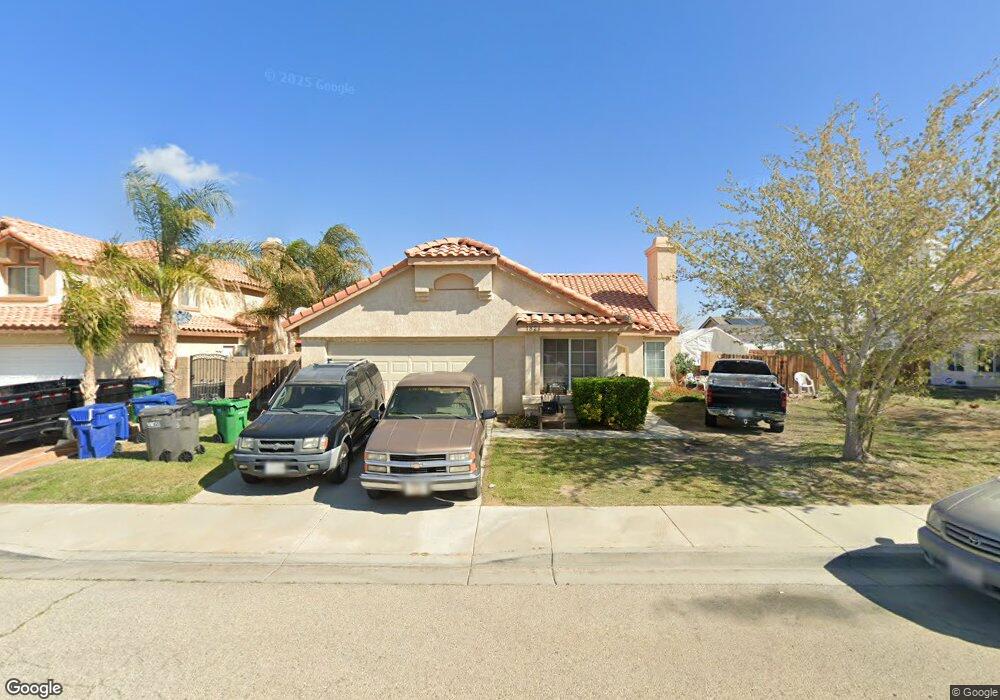
1821 E Milling St Lancaster, CA 93535
East Lancaster NeighborhoodEstimated Value: $394,120 - $449,000
3
Beds
2
Baths
1,560
Sq Ft
$273/Sq Ft
Est. Value
About This Home
This home is located at 1821 E Milling St, Lancaster, CA 93535 and is currently estimated at $426,530, approximately $273 per square foot. 1821 E Milling St is a home located in Los Angeles County with nearby schools including Joshua Elementary, Piute Middle School, and Eastside High School.
Ownership History
Date
Name
Owned For
Owner Type
Purchase Details
Closed on
Jun 9, 2022
Sold by
Duran Victor M and Duran Monica L
Bought by
Victor And Monica Duran Living Trust
Current Estimated Value
Purchase Details
Closed on
Aug 13, 2009
Sold by
Macias Robert D and Olea Susana T
Bought by
Duran Victor M
Home Financials for this Owner
Home Financials are based on the most recent Mortgage that was taken out on this home.
Original Mortgage
$72,000
Interest Rate
5.25%
Mortgage Type
New Conventional
Purchase Details
Closed on
Dec 10, 2004
Sold by
Pataky Barry John and Pataky Sally Jill
Bought by
Macias Robert D
Home Financials for this Owner
Home Financials are based on the most recent Mortgage that was taken out on this home.
Original Mortgage
$183,000
Interest Rate
5.7%
Mortgage Type
Purchase Money Mortgage
Purchase Details
Closed on
Sep 16, 1993
Sold by
Curtis Century Lancaster Company Ii
Bought by
Pataky Barry John
Create a Home Valuation Report for This Property
The Home Valuation Report is an in-depth analysis detailing your home's value as well as a comparison with similar homes in the area
Home Values in the Area
Average Home Value in this Area
Purchase History
| Date | Buyer | Sale Price | Title Company |
|---|---|---|---|
| Victor And Monica Duran Living Trust | -- | Lester Schuck Becker Dehesa & | |
| Duran Victor M | $90,000 | Fidelity National Title Co | |
| Macias Robert D | $253,000 | Fidelity | |
| Pataky Barry John | $105,000 | Lincoln Title Company |
Source: Public Records
Mortgage History
| Date | Status | Borrower | Loan Amount |
|---|---|---|---|
| Previous Owner | Duran Victor M | $72,000 | |
| Previous Owner | Macias Robert D | $183,000 |
Source: Public Records
Tax History
| Year | Tax Paid | Tax Assessment Tax Assessment Total Assessment is a certain percentage of the fair market value that is determined by local assessors to be the total taxable value of land and additions on the property. | Land | Improvement |
|---|---|---|---|---|
| 2025 | $2,841 | $116,158 | $23,226 | $92,932 |
| 2024 | $2,841 | $113,881 | $22,771 | $91,110 |
| 2023 | $2,786 | $111,649 | $22,325 | $89,324 |
| 2022 | $2,609 | $109,461 | $21,888 | $87,573 |
| 2021 | $2,231 | $107,315 | $21,459 | $85,856 |
| 2019 | $2,178 | $104,133 | $20,823 | $83,310 |
| 2018 | $2,142 | $102,092 | $20,415 | $81,677 |
| 2016 | $2,040 | $98,129 | $19,623 | $78,506 |
| 2015 | $2,019 | $96,656 | $19,329 | $77,327 |
| 2014 | $2,024 | $94,764 | $18,951 | $75,813 |
Source: Public Records
Map
Nearby Homes
- 1814 E Milling St
- 0 E Nugent St
- 1733 E Norberry St
- 2113 E Donatello St
- 44640 Driftwood St
- 2036 E Jenner St
- 0 Cor 17th Ste Ketteing St Unit 25000899
- 2009 E Jenner St
- 1639 E Kettering St
- 45064 18th St E
- 2125 E Jackman St
- 2108 Beechwood St
- 44544 15th St E Unit 9
- 44827 Rock Island Dr
- 47700 17th St E
- 44460 15th St E Unit 13
- 2310 Lightcap St
- 1609 Silvia Ave
- 44508 15th St E Unit 12
- 44840 Fenhold St
- 1813 E Milling St
- 1824 E Lingard St
- 1816 E Lingard St
- 1832 E Lingard St
- 1807 E Milling St
- 1837 E Milling St
- 1822 E Milling St
- 1830 E Milling St
- 1810 E Lingard St
- 1840 E Lingard St
- 1808 E Milling St
- 1838 E Milling St
- 1801 E Milling St
- 1845 E Milling St
- 1802 E Lingard St
- 1825 E Lingard St
- 1825 E Newgrove St
- 1846 E Lingard St
- 1817 E Lingard St
- 1833 E Newgrove St
Your Personal Tour Guide
Ask me questions while you tour the home.