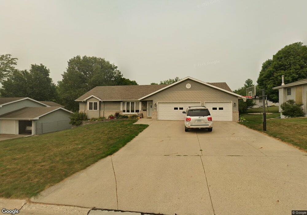
1823 Joan Ave Carroll, IA 51401
Estimated Value: $334,000 - $479,000
5
Beds
3
Baths
1,642
Sq Ft
$228/Sq Ft
Est. Value
About This Home
This home is located at 1823 Joan Ave, Carroll, IA 51401 and is currently estimated at $373,934, approximately $227 per square foot. 1823 Joan Ave is a home located in Carroll County with nearby schools including Fairview Elementary School, Adams Elementary School, and Carroll Middle School.
Ownership History
Date
Name
Owned For
Owner Type
Purchase Details
Closed on
Nov 3, 2014
Sold by
Thobe Mike and Thobe Carol S
Bought by
Sanders Jeffrey A
Current Estimated Value
Home Financials for this Owner
Home Financials are based on the most recent Mortgage that was taken out on this home.
Original Mortgage
$196,000
Outstanding Balance
$110,318
Interest Rate
4.23%
Mortgage Type
New Conventional
Estimated Equity
$263,616
Purchase Details
Closed on
Feb 28, 2010
Sold by
Anderson Steven D and Anderson Sara J
Bought by
Thobe Mike and Thobe Carol S
Home Financials for this Owner
Home Financials are based on the most recent Mortgage that was taken out on this home.
Original Mortgage
$188,000
Interest Rate
5.11%
Mortgage Type
Future Advance Clause Open End Mortgage
Purchase Details
Closed on
Sep 8, 2006
Sold by
Anderson Amy L
Bought by
Anderson Steven D
Create a Home Valuation Report for This Property
The Home Valuation Report is an in-depth analysis detailing your home's value as well as a comparison with similar homes in the area
Home Values in the Area
Average Home Value in this Area
Purchase History
| Date | Buyer | Sale Price | Title Company |
|---|---|---|---|
| Sanders Jeffrey A | $245,000 | Security Title & Investment | |
| Thobe Mike | $189,000 | Security Title & Investment | |
| Anderson Steven D | -- | None Available |
Source: Public Records
Mortgage History
| Date | Status | Borrower | Loan Amount |
|---|---|---|---|
| Open | Sanders Jeffrey A | $196,000 | |
| Previous Owner | Thobe Mike | $188,000 |
Source: Public Records
Tax History Compared to Growth
Tax History
| Year | Tax Paid | Tax Assessment Tax Assessment Total Assessment is a certain percentage of the fair market value that is determined by local assessors to be the total taxable value of land and additions on the property. | Land | Improvement |
|---|---|---|---|---|
| 2025 | $3,802 | $338,900 | $30,820 | $308,080 |
| 2024 | $3,724 | $300,210 | $30,820 | $269,390 |
| 2023 | $3,749 | $300,210 | $30,820 | $269,390 |
| 2022 | $3,556 | $254,280 | $24,660 | $229,620 |
| 2021 | $3,556 | $254,280 | $24,660 | $229,620 |
| 2020 | $3,640 | $254,280 | $24,660 | $229,620 |
| 2019 | $3,640 | $254,280 | $24,660 | $229,620 |
| 2018 | $3,426 | $254,280 | $24,660 | $229,620 |
| 2017 | $3,426 | $247,855 | $25,498 | $222,357 |
| 2016 | $3,192 | $231,640 | $0 | $0 |
| 2015 | $3,192 | $216,750 | $0 | $0 |
| 2014 | $3,066 | $216,750 | $0 | $0 |
Source: Public Records
Map
Nearby Homes
- 265 Perch St
- 219 Windwood Dr
- 1601 N Main St
- 260 Bass St
- 1546 Olive St
- 1515 N Main St
- 746 Granada Rd
- 1509 Birch St
- 1320 N Adams St
- 638 Capistrano Ave
- 621 Alta Vista Dr
- 641 Alta Vista Dr
- 2340 Skyline Dr
- 611 W 21st St
- 718 Alta Vista Dr
- 1852 Quint Ave
- 1550 Edgewood Dr
- 1108 N Main St
- 1102 N Main St
- 631 W 17th St