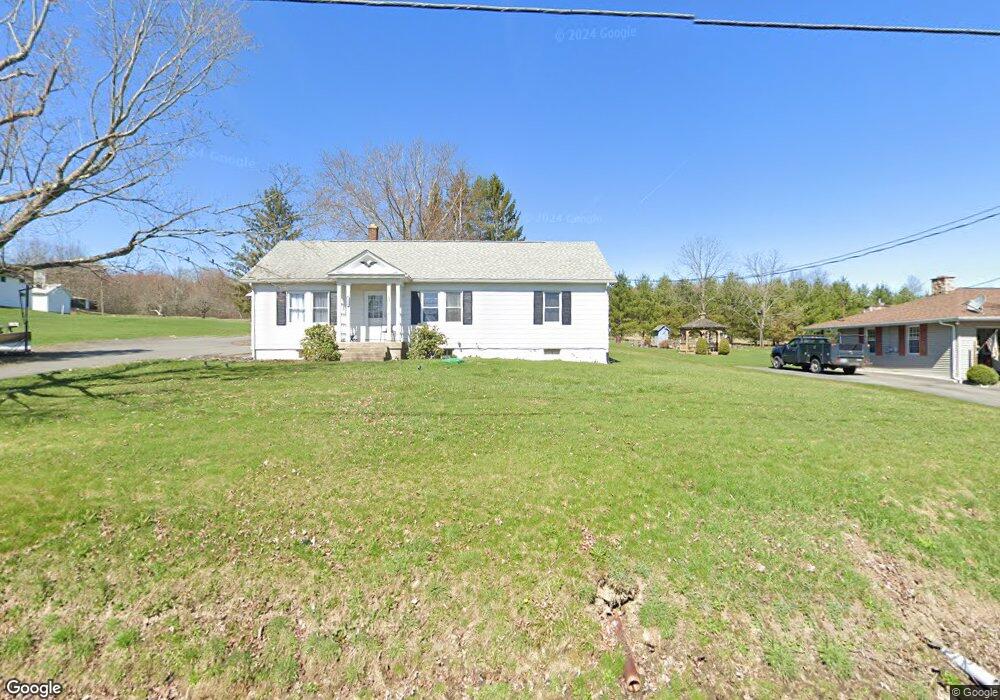
1826 Newton Ransom Blvd Clarks Summit, PA 18411
Estimated Value: $231,000 - $338,000
--
Bed
--
Bath
--
Sq Ft
0.39
Acres
About This Home
This home is located at 1826 Newton Ransom Blvd, Clarks Summit, PA 18411 and is currently estimated at $270,007. 1826 Newton Ransom Blvd is a home located in Lackawanna County with nearby schools including Abington Heights High School.
Ownership History
Date
Name
Owned For
Owner Type
Purchase Details
Closed on
May 20, 2024
Sold by
Hughes Diane and Hollenback Dawn
Bought by
Raker
Current Estimated Value
Purchase Details
Closed on
Jul 6, 2011
Sold by
Hughes Diane and Hughes Joseph
Bought by
Hughes Diane and Hughes Joseph
Purchase Details
Closed on
Jun 30, 2011
Sold by
Hughes Diane and Huggler Ricky
Bought by
Hughes Diane and Hollenback Dawn
Purchase Details
Closed on
Jun 11, 2008
Sold by
Huggler Genevieve and Huggler Genevieve K
Bought by
Hughes Diane and Huggler Ricky
Create a Home Valuation Report for This Property
The Home Valuation Report is an in-depth analysis detailing your home's value as well as a comparison with similar homes in the area
Home Values in the Area
Average Home Value in this Area
Purchase History
| Date | Buyer | Sale Price | Title Company |
|---|---|---|---|
| Raker | $259,000 | Luxe Abstract | |
| Hughes Diane | $66,000 | None Available | |
| Hughes Diane | -- | None Available | |
| Hughes Diane | -- | None Available |
Source: Public Records
Tax History Compared to Growth
Tax History
| Year | Tax Paid | Tax Assessment Tax Assessment Total Assessment is a certain percentage of the fair market value that is determined by local assessors to be the total taxable value of land and additions on the property. | Land | Improvement |
|---|---|---|---|---|
| 2025 | $1,767 | $7,257 | $1,257 | $6,000 |
| 2024 | $1,459 | $7,257 | $1,257 | $6,000 |
| 2023 | $1,459 | $7,257 | $1,257 | $6,000 |
| 2022 | $1,428 | $7,257 | $1,257 | $6,000 |
| 2021 | $1,428 | $7,257 | $1,257 | $6,000 |
| 2020 | $1,428 | $7,257 | $1,257 | $6,000 |
| 2019 | $1,381 | $7,257 | $1,257 | $6,000 |
| 2018 | $1,369 | $7,257 | $1,257 | $6,000 |
| 2017 | $1,361 | $7,257 | $1,257 | $6,000 |
| 2016 | $872 | $7,257 | $1,257 | $6,000 |
| 2015 | -- | $7,257 | $1,257 | $6,000 |
| 2014 | -- | $7,257 | $1,257 | $6,000 |
Source: Public Records
Map
Nearby Homes
- 0 Milwaukee Rd Unit GSBSC254290
- 1932 Newton Ransom Blvd
- 2441 Milwaukee Rd
- 1736 Falls Rd
- 2225 Cherry Hill Rd
- 0 Blvd
- 10 Bald Mt Rd
- 2500 Falls Rd
- 1502 Forest Acres Dr
- 162 Highland Rd
- 9119 Valley View Dr
- 52 Ivywood Dr Unit L 6
- 1215 Country Club Rd
- 9109 Valley View Dr
- 2694 Ransom Rd
- L358 River Rd
- 2352 Newton Ransom Blvd
- 2356 Newton Ransom Blvd
- 83 Hedge Row Run
- 0 Lower Mill City Rd Unit GSBSC254966
- 1824 Newton Ransom Blvd
- 1822 Newton Ransom Blvd
- 1820 Newton Ransom Blvd
- 1818 Newton Ransom Blvd
- 1843 Newton Ransom Blvd
- 1304 School St
- 1306 School St
- 1814 Newton Ransom Blvd
- 440 Rt Newton Center
- 1841 Newton Ransom Blvd
- 1308 School St
- 1301 School St
- 1303 School St
- 1859 Newton Ransom Blvd
- 1310 School St
- 1307 School St
- 13070 Maple Dr
- 1309 School St
- 13074 Lower Maple Dr
- 1314 School St