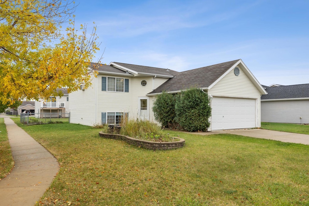
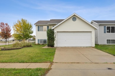
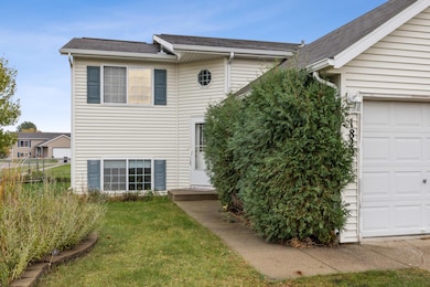
1829 13th St E West Fargo, ND 58078
Arbor Glen NeighborhoodEstimated payment $1,901/month
Highlights
- Popular Property
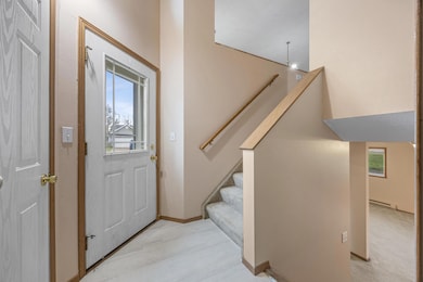
- Lower Floor Utility Room
- Baseboard Heating
- No HOA
- 2 Car Attached Garage
- 3-minute walk to Burlington Commons
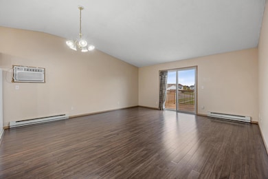
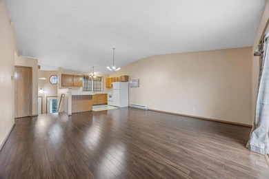
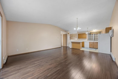
About This Home
You’ll feel right at home in this spacious 3-bedroom, 2-bath property. The open-concept kitchen, dining, and living area creates an easy flow for cooking, entertaining, or relaxing. Step outside to a fully fenced backyard—perfect for pets, play, or gathering with friends. The large family room offers even more space to spread out and enjoy. With a beautifully maintained yard, ultra-low specials, and a prime location near a park and all your favorite FM amenities, this home truly checks all the boxes.
Home Details
Home Type
- Single Family
Est. Annual Taxes
- $3,500
Year Built
- Built in 2003
Lot Details
- Property is Fully Fenced
Parking
- 2 Car Attached Garage
Home Design
- Bi-Level Home
- Wood Foundation
Interior Spaces
- Lower Floor Utility Room
Bedrooms and Bathrooms
- 3 Bedrooms
- 2 Full Bathrooms
Schools
- West Fargo High School
Utilities
- Cooling System Mounted In Outer Wall Opening
- Baseboard Heating
Community Details
- No Home Owners Association
- Huntington Woods Add Subdivision
Listing and Financial Details
- Assessor Parcel Number 02083501020000
Map
Home Values in the Area
Average Home Value in this Area
Tax History
| Year | Tax Paid | Tax Assessment Tax Assessment Total Assessment is a certain percentage of the fair market value that is determined by local assessors to be the total taxable value of land and additions on the property. | Land | Improvement |
|---|---|---|---|---|
| 2024 | $3,532 | $119,600 | $18,800 | $100,800 |
| 2023 | $3,403 | $114,200 | $18,800 | $95,400 |
| 2022 | $3,302 | $106,400 | $18,800 | $87,600 |
| 2021 | $3,209 | $99,650 | $12,950 | $86,700 |
| 2020 | $3,043 | $96,950 | $12,950 | $84,000 |
| 2019 | $2,788 | $94,000 | $12,950 | $81,050 |
| 2018 | $2,707 | $94,100 | $12,950 | $81,150 |
| 2017 | $2,637 | $93,300 | $12,950 | $80,350 |
| 2016 | $2,370 | $91,200 | $12,950 | $78,250 |
| 2015 | $2,319 | $82,800 | $7,400 | $75,400 |
| 2014 | $2,127 | $77,400 | $7,400 | $70,000 |
| 2013 | $2,043 | $74,050 | $7,400 | $66,650 |
Property History
| Date | Event | Price | List to Sale | Price per Sq Ft |
|---|---|---|---|---|
| 12/15/2025 12/15/25 | For Rent | $2,000 | 0.0% | -- |
| 12/08/2025 12/08/25 | For Sale | $309,900 | -- | $159 / Sq Ft |
Purchase History
| Date | Type | Sale Price | Title Company |
|---|---|---|---|
| Quit Claim Deed | -- | None Available | |
| Warranty Deed | -- | -- | |
| Warranty Deed | -- | -- |
Mortgage History
| Date | Status | Loan Amount | Loan Type |
|---|---|---|---|
| Previous Owner | $19,950 | Purchase Money Mortgage | |
| Previous Owner | $144,900 | New Conventional |
Source: NorthstarMLS
MLS Number: 6825078
APN: 02-0835-01020-000
Disclaimer: Certain information contained herein is derived from information provided by parties other than Homes.com. All information provided is deemed reliable, but is not guaranteed to be accurate and should be independently verified.
![]() Based on information submitted to the MLS GRID. All data is obtained from various sources and may not have been verified by broker or MLS GRID. Supplied Open House Information is subject to change without notice. All information should be independently reviewed and verified for accuracy. Properties may or may not be listed by the office/agent presenting the information. Some IDX listings have been excluded from this website.
Based on information submitted to the MLS GRID. All data is obtained from various sources and may not have been verified by broker or MLS GRID. Supplied Open House Information is subject to change without notice. All information should be independently reviewed and verified for accuracy. Properties may or may not be listed by the office/agent presenting the information. Some IDX listings have been excluded from this website.
The Digital Millennium Copyright Act of 1998, 17 U.S.C. § 512 (the “DMCA”) provides recourse for copyright owners who believe that material appearing on the Internet infringes their rights under U.S. copyright law. If you believe in good faith that any content or material made available in connection with our website or services infringes your copyright, you (or your agent) may send us a notice requesting that the content or material be removed, or access to it blocked.
Notices must be sent in writing by email to DMCAnotice@MLSGrid.com.
The DMCA requires that your notice of alleged copyright infringement include the following information:
(1) description of the copyrighted work that is the subject of claimed infringement;
(2) description of the alleged infringing content and information sufficient to permit us to locate the content;
(3) contact information for you, including your address, telephone number and email address;
(4) a statement by you that you have a good faith belief that the content in the manner complained of is not authorized by the copyright owner, or its agent, or by the operation of any law;
(5) a statement by you, signed under penalty of perjury, that the information in the notification is accurate and that you have the authority to enforce the copyrights that are claimed to be infringed; and
(6) a physical or electronic signature of the copyright owner or a person authorized to act on the copyright owner’s behalf. Failure to include all of the above information may result in the delay of the processing of your complaint.
- 1836 12th St E
- 1845 Huntington Ct
- 1970 Burlington Dr
- 1842 52nd St S
- 724 Northridge Way
- 1811 7th St E
- 783 14 1 2 Ave E
- 722 14 1 2 Ave E
- 820 26th Ave E
- 517 18th Ave E
- 1511 11th Ave E
- 1423 10th Ave E Unit 206
- 134 17th Ave E
- 336 13th Ave E
- 306 13th Ave E
- 1844 1st St
- 801 9th St E
- 2432 Mcleod Dr E
- 921 Homestead Ct
- 245 12th Ave E
- 1305 Queens Way
- 4955 17th Ave S
- 1850 49th St S
- 1910 49th St SW
- 1401 12th St E Unit 17
- 1121 14th Ave E Unit 2
- 1321 14th Ave E
- 1415 14th Ave E
- 1415 14th Ave E Unit 20
- 1415 14th Ave E Unit 21
- 1515 14th Ave E Unit 12
- 1515 14th Ave E Unit 9
- 2366-2382 55th St S
- 5101 Amber Valley Pkwy S
- 4720 16th Ave SW
- 4802 15th Ave S
- 5400-5420 Amber Valley Pkwy S
- 5001-5055 Amber Valley Pkwy S
- 5170 Amber Valley Pkwy S
- 4854-5150 Amber Valley Pkwy S
