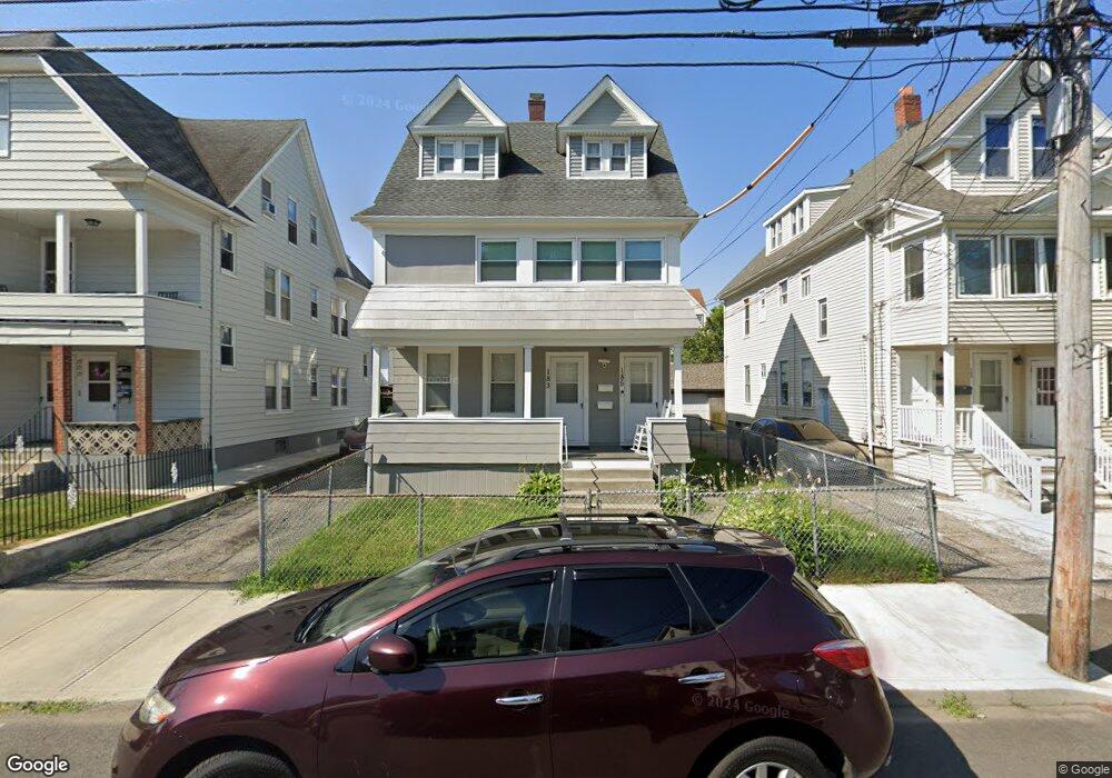
183 Parrott Ave Bridgeport, CT 06606
Brooklawn-Saint Vincent NeighborhoodEstimated Value: $404,816 - $660,000
7
Beds
3
Baths
2,602
Sq Ft
$218/Sq Ft
Est. Value
About This Home
This home is located at 183 Parrott Ave, Bridgeport, CT 06606 and is currently estimated at $567,204, approximately $217 per square foot. 183 Parrott Ave is a home located in Fairfield County with nearby schools including Read School, Central High School, and Catholic Academy of Bridgeport-St. Raphael Academy.
Ownership History
Date
Name
Owned For
Owner Type
Purchase Details
Closed on
May 25, 2022
Sold by
Darden Mamie
Bought by
Darden Mamie and Williams Luwanda
Current Estimated Value
Purchase Details
Closed on
Sep 11, 1987
Sold by
Skyers Vashti
Bought by
Hilton Amos
Home Financials for this Owner
Home Financials are based on the most recent Mortgage that was taken out on this home.
Original Mortgage
$155,250
Interest Rate
10.27%
Mortgage Type
Purchase Money Mortgage
Create a Home Valuation Report for This Property
The Home Valuation Report is an in-depth analysis detailing your home's value as well as a comparison with similar homes in the area
Home Values in the Area
Average Home Value in this Area
Purchase History
| Date | Buyer | Sale Price | Title Company |
|---|---|---|---|
| Darden Mamie | -- | None Available | |
| Darden Mamie | -- | None Available | |
| Darden Mamie | -- | None Available | |
| Hilton Amos | $86,250 | -- |
Source: Public Records
Mortgage History
| Date | Status | Borrower | Loan Amount |
|---|---|---|---|
| Previous Owner | Hilton Amos | $155,862 | |
| Previous Owner | Hilton Amos | $154,000 | |
| Previous Owner | Hilton Amos | $155,250 |
Source: Public Records
Tax History
| Year | Tax Paid | Tax Assessment Tax Assessment Total Assessment is a certain percentage of the fair market value that is determined by local assessors to be the total taxable value of land and additions on the property. | Land | Improvement |
|---|---|---|---|---|
| 2025 | $6,866 | $158,020 | $63,810 | $94,210 |
| 2024 | $6,866 | $158,020 | $63,810 | $94,210 |
| 2023 | $6,866 | $158,020 | $63,810 | $94,210 |
| 2022 | $6,866 | $158,020 | $63,810 | $94,210 |
| 2021 | $6,866 | $158,020 | $63,810 | $94,210 |
| 2020 | $6,288 | $116,470 | $38,680 | $77,790 |
| 2019 | $6,288 | $116,470 | $38,680 | $77,790 |
| 2018 | $6,332 | $116,470 | $38,680 | $77,790 |
| 2017 | $6,332 | $116,470 | $38,680 | $77,790 |
| 2016 | $6,332 | $116,470 | $38,680 | $77,790 |
| 2015 | $6,105 | $144,680 | $39,000 | $105,680 |
| 2014 | $6,105 | $144,680 | $39,000 | $105,680 |
Source: Public Records
Map
Nearby Homes
- 201 French St Unit 203
- 345 Capitol Ave
- 248 Salem St
- 92 Lincoln Ave
- 708 Capitol Ave Unit 710
- 157 Anson St
- 78 Fairmount Ave
- 108 Lindley St Unit 114
- 936 Lindley St
- 23-25 Morgan Ave
- 208 Fairview Ave Unit 210
- 329 Ezra St
- 123 Harlem Ave
- 74 Harlem Ave
- 926 Hart St
- 916 Hart St
- 457 Summit St
- 25 Westfield Ave
- 203 Wayne St
- 254 Wayne St
- 191 Parrott Ave
- 191 Parrott Ave Unit 1
- 191 Parrott Ave Unit 3rd
- 175 Parrott Ave
- 179 Parrott Ave Unit 3
- 167 Parrott Ave
- 205 Parrott Ave
- 178 Parrott Ave
- 161 Parrott Ave
- 194 Parrott Ave Unit 196
- 194 Parrott Ave Unit 3 RD
- 186 Parrott Ave
- 202 Parrott Ave
- 170 Parrott Ave
- 200 Whitney Ave Unit 204
- 210 Whitney Ave
- 180 Whitney Ave
- 172 Parrott Ave
- 190 Whitney Ave Unit 3rd Apartment
Your Personal Tour Guide
Ask me questions while you tour the home.