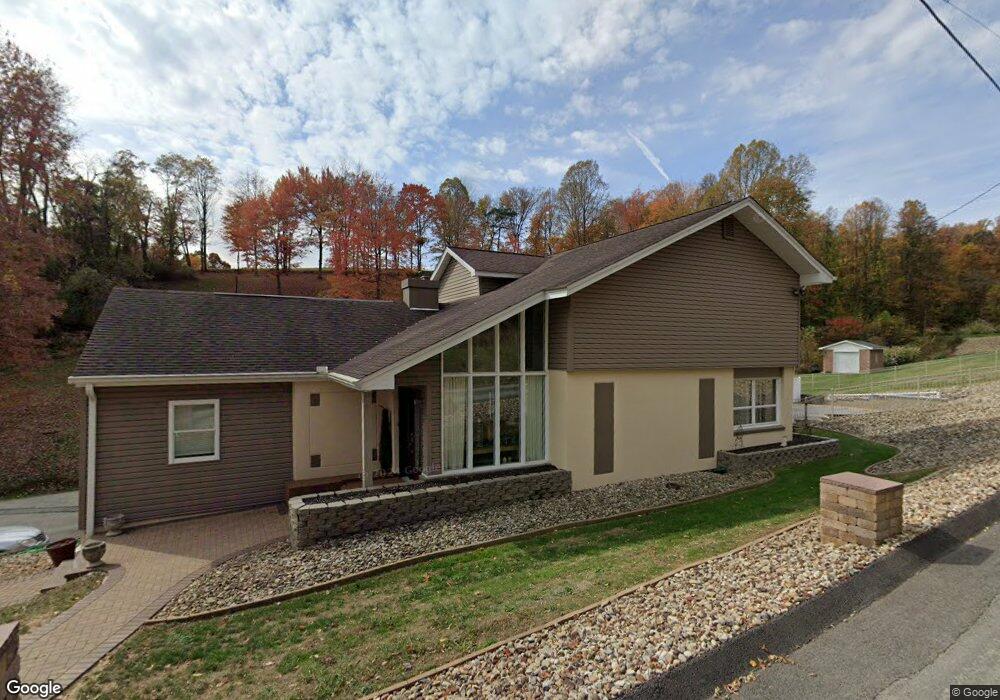
183 Ransel Rd Latrobe, PA 15650
Estimated Value: $86,008 - $442,000
Studio
--
Bath
3,222
Sq Ft
$95/Sq Ft
Est. Value
About This Home
This home is located at 183 Ransel Rd, Latrobe, PA 15650 and is currently estimated at $307,252, approximately $95 per square foot. 183 Ransel Rd is a home with nearby schools including Greater Latrobe Junior High School, Greater Latrobe Senior High School, and High Acres School.
Ownership History
Date
Name
Owned For
Owner Type
Purchase Details
Closed on
May 9, 2023
Sold by
Philips-Douds Constance L and Philips-Douds Richard F
Bought by
Testa Wendy Marie and Giannini Ryan Alan
Current Estimated Value
Purchase Details
Closed on
Dec 26, 2019
Sold by
Philips Constance L and Douds Richard F
Bought by
Philips Constance L and Douds Richard F
Purchase Details
Closed on
Dec 4, 2006
Sold by
Philips Michael C and Philips Constance L
Bought by
Philips Michael C and Philips Constance L
Home Financials for this Owner
Home Financials are based on the most recent Mortgage that was taken out on this home.
Original Mortgage
$301,000
Interest Rate
6.4%
Mortgage Type
Stand Alone Refi Refinance Of Original Loan
Create a Home Valuation Report for This Property
The Home Valuation Report is an in-depth analysis detailing your home's value as well as a comparison with similar homes in the area
Home Values in the Area
Average Home Value in this Area
Purchase History
| Date | Buyer | Sale Price | Title Company |
|---|---|---|---|
| Testa Wendy Marie | -- | None Listed On Document | |
| Philips Constance L | -- | None Available | |
| Philips Michael C | -- | None Available |
Source: Public Records
Mortgage History
| Date | Status | Borrower | Loan Amount |
|---|---|---|---|
| Previous Owner | Philips Michael C | $301,000 |
Source: Public Records
Tax History
| Year | Tax Paid | Tax Assessment Tax Assessment Total Assessment is a certain percentage of the fair market value that is determined by local assessors to be the total taxable value of land and additions on the property. | Land | Improvement |
|---|---|---|---|---|
| 2025 | $3,132 | $25,950 | $2,500 | $23,450 |
| 2024 | $3,132 | $25,950 | $2,500 | $23,450 |
| 2023 | $2,872 | $25,950 | $2,500 | $23,450 |
| 2022 | $2,872 | $25,950 | $2,500 | $23,450 |
| 2021 | $2,846 | $25,950 | $2,500 | $23,450 |
| 2020 | $2,801 | $25,950 | $2,500 | $23,450 |
| 2019 | $2,762 | $25,950 | $2,500 | $23,450 |
| 2018 | $2,749 | $25,950 | $2,500 | $23,450 |
| 2017 | $2,678 | $25,950 | $2,500 | $23,450 |
| 2016 | $628 | $25,950 | $2,500 | $23,450 |
| 2015 | $628 | $25,950 | $2,500 | $23,450 |
| 2014 | -- | $25,950 | $2,500 | $23,450 |
Source: Public Records
Map
Nearby Homes
- 359 Meadow Spring Rd
- 1580 Lois Ln
- 1582 Lois Ln Unit Lot 11 B
- 1610 Lois Ln
- 1602 Lois Ln
- 1614 Lois Ln
- 133 Winslow Ct
- 214 Denali Dr Unit 856B
- 113 Mount Ranier Dr
- 5009 Linwood Court (Lot #206)
- T-604 Frye Farm Rd
- 1127 Mckenna Way
- 1212 Mountain View Dr
- 307 Persian Ln
- 1113 B St
- 6004 Mason Dr
- 1108 B St
- 74 Quail Run
- 659 Alexander Rd
- 915 Jamell Dr
- 175 Ransel Rd
- 191 Ransel Rd
- 168 Ransel Rd
- 165 Ransel Rd
- 153 Ransel Rd
- 143 Ransel Rd
- 158 Ransel Rd
- 387 Meadow Spring Rd
- 160 Ransel Rd
- 375 Meadow Spring Rd
- 123 Ransel Rd
- 255 Beatty County Rd
- 363 Meadow Spring Rd
- 113 Ransel Rd
- 353 Meadow Spring Rd
- 000 Meadow Springs
- 347 Meadow Spring Rd
- 422 Meadow Spring Rd
- 430 Meadow Spring Rd
- 430 Meadow Spring Rd
Your Personal Tour Guide
Ask me questions while you tour the home.