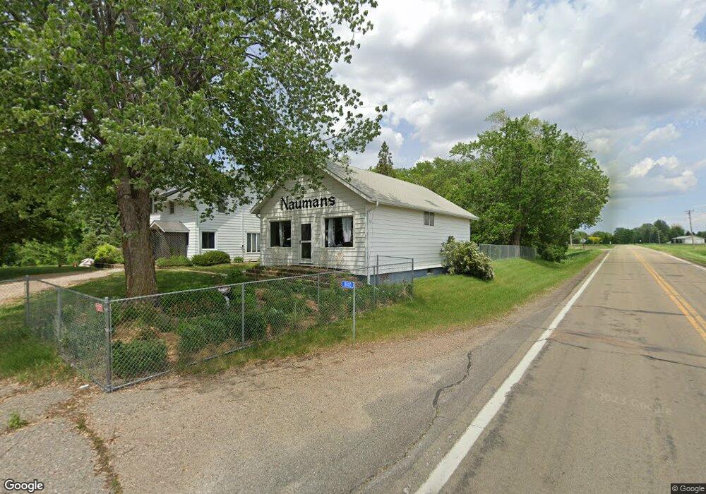
18300 Cannon City Blvd Faribault, MN 55021
Estimated Value: $394,266 - $494,000
5
Beds
2
Baths
1,714
Sq Ft
$262/Sq Ft
Est. Value
About This Home
This home is located at 18300 Cannon City Blvd, Faribault, MN 55021 and is currently estimated at $448,317, approximately $261 per square foot. 18300 Cannon City Blvd is a home located in Rice County with nearby schools including Roosevelt Elementary School, Faribault Middle School, and Faribault Senior High School.
Ownership History
Date
Name
Owned For
Owner Type
Purchase Details
Closed on
Apr 17, 2025
Sold by
Piper Crystal A and Sargent Luke R
Bought by
Blucannon Farm Revocable Trust and Sargent
Current Estimated Value
Purchase Details
Closed on
Aug 19, 2019
Sold by
Truman Sherry L and Feyereisn Sharleen S
Bought by
Piper Crystal A and Sargent Luke R
Home Financials for this Owner
Home Financials are based on the most recent Mortgage that was taken out on this home.
Original Mortgage
$299,250
Interest Rate
3.6%
Mortgage Type
New Conventional
Create a Home Valuation Report for This Property
The Home Valuation Report is an in-depth analysis detailing your home's value as well as a comparison with similar homes in the area
Home Values in the Area
Average Home Value in this Area
Purchase History
| Date | Buyer | Sale Price | Title Company |
|---|---|---|---|
| Blucannon Farm Revocable Trust | $500 | None Listed On Document | |
| Piper Crystal A | $315,000 | None Available |
Source: Public Records
Mortgage History
| Date | Status | Borrower | Loan Amount |
|---|---|---|---|
| Previous Owner | Piper Crystal A | $299,250 |
Source: Public Records
Tax History Compared to Growth
Tax History
| Year | Tax Paid | Tax Assessment Tax Assessment Total Assessment is a certain percentage of the fair market value that is determined by local assessors to be the total taxable value of land and additions on the property. | Land | Improvement |
|---|---|---|---|---|
| 2025 | $2,698 | $366,500 | $109,000 | $257,500 |
| 2024 | $2,698 | $336,400 | $95,000 | $241,400 |
| 2023 | $2,464 | $336,400 | $95,000 | $241,400 |
| 2022 | $2,098 | $304,600 | $84,000 | $220,600 |
| 2021 | $1,968 | $258,900 | $74,300 | $184,600 |
| 2020 | $1,114 | $244,000 | $71,800 | $172,200 |
| 2019 | $1,062 | $207,700 | $66,600 | $141,100 |
Source: Public Records
Map
Nearby Homes
- 2110 Goldenray Dr
- 2135 Violet Ln
- Parkdale Plan at The Meadows
- St. Croix Plan at The Meadows
- McKenna Plan at The Meadows
- Monroe Plan at The Meadows
- Mayberry Plan at The Meadows
- Marquette Plan at The Meadows
- Majestic Plan at The Meadows
- Macalaster Plan at The Meadows
- Linden Plan at The Meadows
- Hammond Plan at The Meadows
- Everleigh Plan at The Meadows
- Garrison Plan at The Meadows
- Enclave II Plan at The Meadows
- Eastbrook Plan at The Meadows
- Cottonwood II Plan at The Meadows
- Canton II Plan at The Meadows
- Bellefonte Plan at The Meadows
- Virginia Plan at The Meadows
- 18352 Cannon City Blvd
- 18200 Cagger Trail
- 4360 Dayton Cir
- 4370 Dayton Cir
- 18108 Cannon City Blvd
- 4390 Dayton Cir
- 4350 Dayton Cir
- 4340 Dayton Cir
- 4400 Dayton Cir
- 4402 Decker Trail S
- 18051 18051 Cannon City-Boulevard-
- 18051 18051 Cannon City Blvd
- 18051 Cannon City Blvd
- XYZ Decker Trail
- 4320 Decker Trail
- 4325 Decker Trail
- 4388 Decker Trail S
- CDFG Decker Trail
- 18536 Cannon City Blvd
- Lot 4 Blk 2 Decker Trail