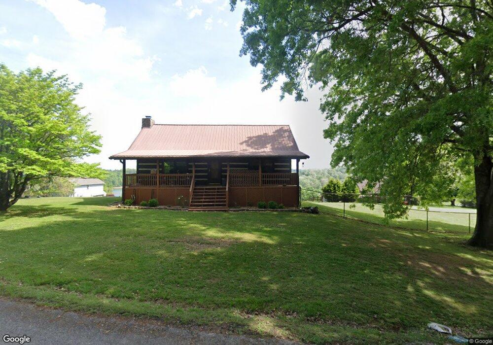
1832 Honeysuckle Ln Talbott, TN 37877
Estimated Value: $274,526 - $638,000
Studio
1
Bath
2,240
Sq Ft
$170/Sq Ft
Est. Value
About This Home
This home is located at 1832 Honeysuckle Ln, Talbott, TN 37877 and is currently estimated at $381,382, approximately $170 per square foot. 1832 Honeysuckle Ln is a home located in Hamblen County with nearby schools including Alpha Elementary School, West View Middle School, and Morristown West High School.
Ownership History
Date
Name
Owned For
Owner Type
Purchase Details
Closed on
Oct 26, 1994
Sold by
Mcnabb Michael
Bought by
Doug Miller
Current Estimated Value
Purchase Details
Closed on
Feb 26, 1994
Sold by
Mcnabb Michael and Mcnabb Dalton M
Bought by
Michael Mcnabb
Purchase Details
Closed on
Feb 1, 1988
Bought by
Mcnabb Michael L and Dalton Michelle
Purchase Details
Closed on
May 1, 1987
Bought by
Mcdavid Timothy M
Purchase Details
Closed on
May 23, 1985
Bought by
Spearman Yvette D and Haley Jeff
Purchase Details
Closed on
Aug 23, 1979
Bought by
Mcguffin Lumber Co Inc
Purchase Details
Closed on
Aug 5, 1977
Bought by
Black Gilbert E
Create a Home Valuation Report for This Property
The Home Valuation Report is an in-depth analysis detailing your home's value as well as a comparison with similar homes in the area
Purchase History
| Date | Buyer | Sale Price | Title Company |
|---|---|---|---|
| Doug Miller | $64,900 | -- | |
| Michael Mcnabb | -- | -- | |
| Mcnabb Michael L | $56,300 | -- | |
| Mcdavid Timothy M | $48,500 | -- | |
| Spearman Yvette D | -- | -- | |
| Mcguffin Lumber Co Inc | -- | -- | |
| Black Gilbert E | -- | -- |
Source: Public Records
Tax History
| Year | Tax Paid | Tax Assessment Tax Assessment Total Assessment is a certain percentage of the fair market value that is determined by local assessors to be the total taxable value of land and additions on the property. | Land | Improvement |
|---|---|---|---|---|
| 2025 | $986 | $67,050 | $11,475 | $55,575 |
| 2024 | $741 | $37,625 | $7,650 | $29,975 |
| 2023 | $741 | $37,625 | $0 | $0 |
| 2022 | $741 | $37,625 | $7,650 | $29,975 |
| 2021 | $741 | $37,625 | $7,650 | $29,975 |
| 2020 | $741 | $37,625 | $7,650 | $29,975 |
| 2019 | $707 | $33,200 | $9,150 | $24,050 |
| 2018 | $707 | $33,200 | $9,150 | $24,050 |
| 2017 | $707 | $33,200 | $9,150 | $24,050 |
| 2016 | $661 | $33,200 | $9,150 | $24,050 |
| 2015 | $614 | $33,200 | $9,150 | $24,050 |
| 2014 | -- | $33,200 | $9,150 | $24,050 |
| 2013 | -- | $35,025 | $0 | $0 |
Source: Public Records
Map
Nearby Homes
- 7713 Melanie Cir
- tbd Lebanon Church Rd
- 2107 Windy Cove Ln
- 7346 Circle Point Dr
- 1437 Beacon Rd
- 8070 W Pointe Dr
- Lot 135 W Point Dr
- 1256 Pratt Rd
- 634 Heather Brook Cir
- 2151 Frank Hodge Rd
- 254 Alberts Cove
- 211 Sequoyah Trail
- 487 Heather Brook Dr
- 1167 Cherry Blossom Ln
- Lot 3 Lowe Dr
- Lot 1R1 Lowe Dr
- 1065 Briar Ct
- 595 Ricky Dr
- 1050 Briar Ct
- 2559 Dogwood Ln
- 1853 Wilderness Dr
- 1825 Wilderness Dr
- 1850 Honeysuckle Ln
- 1887 Wilderness Dr
- 1780 Honeysuckle Ln
- 1911 Wilderness Dr
- 1826 Wilderness Dr
- 1854 Wilderness Dr
- 1772 Wilderness Dr
- 1741 Wilderness Dr
- 1740 Pointe Dr
- 1740 Pointe Dr Dr
- 1937 Wilderness Dr
- 1756 Wilderness Dr
- 1880 Pointe Dr
- 1742 Wilderness Dr
- 1949 Wilderness Dr
- LOT 6 Wilderness Dr
- 1945 Pointe Dr
- 1936 Wilderness Dr
Your Personal Tour Guide
Ask me questions while you tour the home.