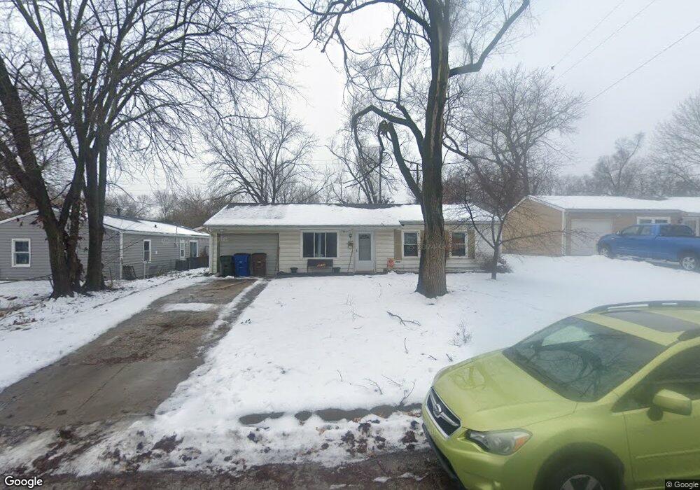
1833 Brook St Lawrence, KS 66044
Brook Creek NeighborhoodEstimated Value: $190,000 - $200,000
3
Beds
1
Bath
925
Sq Ft
$212/Sq Ft
Est. Value
About This Home
This home is located at 1833 Brook St, Lawrence, KS 66044 and is currently estimated at $195,875, approximately $211 per square foot. 1833 Brook St is a home located in Douglas County with nearby schools including New York Elementary School, Liberty Memorial Central Middle School, and Lawrence High School.
Ownership History
Date
Name
Owned For
Owner Type
Purchase Details
Closed on
Mar 24, 2006
Sold by
Clowers Angela C and Gillaspie Kevin G
Bought by
Gillaspie Kevin G and Gillaspie Angela C
Current Estimated Value
Home Financials for this Owner
Home Financials are based on the most recent Mortgage that was taken out on this home.
Original Mortgage
$87,400
Interest Rate
5.99%
Mortgage Type
Fannie Mae Freddie Mac
Create a Home Valuation Report for This Property
The Home Valuation Report is an in-depth analysis detailing your home's value as well as a comparison with similar homes in the area
Home Values in the Area
Average Home Value in this Area
Purchase History
| Date | Buyer | Sale Price | Title Company |
|---|---|---|---|
| Gillaspie Kevin G | -- | Northwest Title & Escrow |
Source: Public Records
Mortgage History
| Date | Status | Borrower | Loan Amount |
|---|---|---|---|
| Closed | Gillaspie Kevin G | $87,400 |
Source: Public Records
Tax History
| Year | Tax Paid | Tax Assessment Tax Assessment Total Assessment is a certain percentage of the fair market value that is determined by local assessors to be the total taxable value of land and additions on the property. | Land | Improvement |
|---|---|---|---|---|
| 2025 | $2,522 | $21,011 | $5,750 | $15,261 |
| 2024 | $2,491 | $20,758 | $5,405 | $15,353 |
| 2023 | $2,618 | $20,700 | $5,175 | $15,525 |
| 2022 | $2,306 | $18,170 | $4,600 | $13,570 |
| 2021 | $1,958 | $14,842 | $4,368 | $10,474 |
| 2020 | $1,801 | $13,743 | $4,368 | $9,375 |
| 2019 | $1,645 | $12,597 | $3,798 | $8,799 |
| 2018 | $1,586 | $12,066 | $3,571 | $8,495 |
| 2017 | $1,461 | $11,023 | $3,571 | $7,452 |
| 2016 | $1,388 | $10,948 | $3,450 | $7,498 |
| 2015 | -- | $10,741 | $3,450 | $7,291 |
| 2014 | -- | $10,983 | $3,450 | $7,533 |
Source: Public Records
Map
Nearby Homes
- 1813 Miller Dr
- 1919 Clare Rd
- 1419 E 19th St
- 2014 Maple Ln
- 931 Lasalle St
- 717 Beatnik Ct
- 1618 E Glenn Dr
- 1708 E 21st Terrace
- 1605 E 21st Place
- 5701 Johnson Ave
- 5804 Johnson Ave
- 907 Anna Tappan Way
- 903 Anna Tappan Way
- 1603 Harper St
- 1447 Summit St
- 1516 Powers St
- 917 E 13th St
- 414 Forrest Ave
- 1644 Barker Ave
- 1634 Rhode Island St
Your Personal Tour Guide
Ask me questions while you tour the home.