
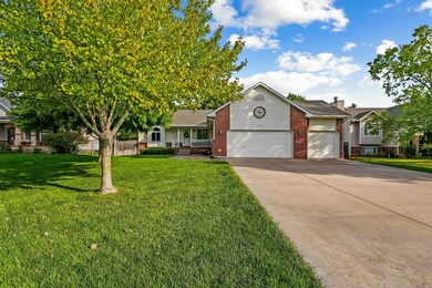
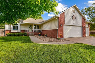
1834 N Columbine Cir Andover, KS 67002
Estimated payment $2,206/month
Highlights
- Deck
- Vaulted Ceiling
- Jogging Path
- Robert M. Martin Elementary School Rated A
- Corner Lot
- Walk-In Closet
About This Home
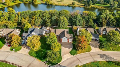
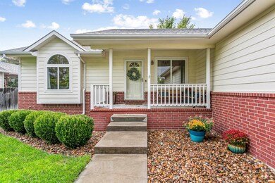
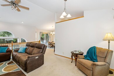
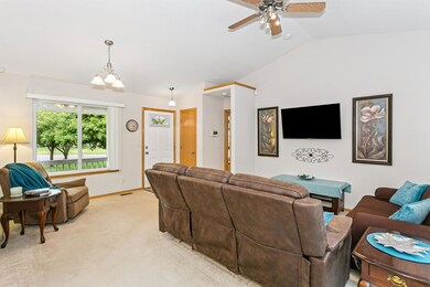
Welcome to this exceptional 5 bedroom, 3 bath ranch style home with a 3 car garage, perfectly situated on a beautifully manicured lot with no neighbors behind! The curb appeal is amazing with lush green grass maintained by an irrigation well and sprinkler system, mature trees offering shade and character, and stately red brick paired with neutral exterior colors for a classic and welcoming feel. As you approach the home, the covered front porch invites you to relax and enjoy a quiet Kansas evening or the colors of a fall afternoon. Inside, the home is filled with natural light and offers an open and effortless layout, featuring white neutral walls, vaulted ceilings, and a seamless flow from the living room to the dining area and kitchen. The kitchen is clean and inviting, with ample counter space, a convenient eating bar for two, and all appliances included, even the washer and dryer! The master suite is a tranquil retreat with vaulted ceilings, generous space, a view of the lush yard, a large walk in closet, and a spa like en suite bath with dual sinks, a soaker tub, a walk in shower, and abundant built in linen storage. The finished view out basement is a standout with freshly updated finishes, including soft gray paint, plush carpet, modern light fixtures, and recessed LED lighting, creating a bright and comfortable space for relaxing or entertaining. Downstairs features a dry bar, two large bedrooms with backyard facing view out windows, a full bath, and a spacious layout perfect for family gatherings or quiet movie nights. Outside, the back deck leads down to an expansive concrete patio that is perfect for entertaining, with mature trees offering shade and a serene backdrop of seasonal color. There is even a manicured path through the trees that leads to the lake immediately behind the home. Fishing is permitted. Additional updates include a new HVAC system and water heater, both installed in 2021, and a mid level walkout for convenient access to the backyard. Located just steps from the Redbud Trail, Andover District Stadium, Cottonwood Elementary, and Kansas Medical Center, this immaculate and move in ready home offers timeless appeal, practical updates, and a wonderful setting to enjoy for years to come.
Home Details
Home Type
- Single Family
Est. Annual Taxes
- $4,712
Year Built
- Built in 2001
Lot Details
- 0.27 Acre Lot
- Wood Fence
- Corner Lot
- Sprinkler System
HOA Fees
- $21 Monthly HOA Fees
Parking
- 3 Car Garage
Home Design
- Brick Exterior Construction
- Composition Roof
Interior Spaces
- 1-Story Property
- Vaulted Ceiling
- Ceiling Fan
- Recessed Lighting
- Living Room
- Combination Kitchen and Dining Room
- Walk-Out Basement
Kitchen
- Dishwasher
- Disposal
Flooring
- Carpet
- Laminate
Bedrooms and Bathrooms
- 5 Bedrooms
- Walk-In Closet
- 3 Full Bathrooms
Laundry
- Laundry on main level
- Dryer
- Washer
- 220 Volts In Laundry
Outdoor Features
- Deck
- Patio
Schools
- Andover Elementary School
- Andover High School
Utilities
- Forced Air Heating and Cooling System
- Heating System Uses Natural Gas
- Irrigation Well
Listing and Financial Details
- Assessor Parcel Number 008-303-07-0-10-04-055.00-0
Community Details
Overview
- Association fees include gen. upkeep for common ar
- $100 HOA Transfer Fee
- North Meadows Subdivision
Recreation
- Jogging Path
Map
Home Values in the Area
Average Home Value in this Area
Tax History
| Year | Tax Paid | Tax Assessment Tax Assessment Total Assessment is a certain percentage of the fair market value that is determined by local assessors to be the total taxable value of land and additions on the property. | Land | Improvement |
|---|---|---|---|---|
| 2025 | $47 | $30,785 | $2,732 | $28,053 |
| 2024 | $47 | $31,752 | $2,506 | $29,246 |
| 2023 | $4,596 | $30,694 | $2,506 | $28,188 |
| 2022 | $3,412 | $24,967 | $2,506 | $22,461 |
| 2021 | $3,412 | $21,344 | $2,506 | $18,838 |
| 2020 | $3,447 | $21,344 | $2,103 | $19,241 |
| 2019 | $3,412 | $20,935 | $2,103 | $18,832 |
| 2018 | $3,338 | $20,573 | $2,103 | $18,470 |
| 2017 | $3,019 | $18,642 | $1,988 | $16,654 |
| 2014 | -- | $150,900 | $17,290 | $133,610 |
Property History
| Date | Event | Price | List to Sale | Price per Sq Ft |
|---|---|---|---|---|
| 10/14/2025 10/14/25 | Pending | -- | -- | -- |
| 10/08/2025 10/08/25 | For Sale | $340,000 | -- | $129 / Sq Ft |
Purchase History
| Date | Type | Sale Price | Title Company |
|---|---|---|---|
| Warranty Deed | -- | Security 1St Title | |
| Deed | $158,625 | Security First Title |
Mortgage History
| Date | Status | Loan Amount | Loan Type |
|---|---|---|---|
| Open | $126,900 | New Conventional |
Source: South Central Kansas MLS
MLS Number: 663063
APN: 303-07-0-10-04-055-00-0
Disclaimer: Certain information contained herein is derived from information provided by parties other than Homes.com. All information provided is deemed reliable, but is not guaranteed to be accurate and should be independently verified.
![]() IDX information is provided exclusively for personal, non-commercial use, and may not be used for any purpose other than to identify prospective properties consumers may be interested in purchasing. This information is not verified for authenticity or accuracy, is not guaranteed and may not reflect all real estate activity in the market. © 1993-2025 South Central Kansas Multiple Listing Service, Inc. All rights reserved.
IDX information is provided exclusively for personal, non-commercial use, and may not be used for any purpose other than to identify prospective properties consumers may be interested in purchasing. This information is not verified for authenticity or accuracy, is not guaranteed and may not reflect all real estate activity in the market. © 1993-2025 South Central Kansas Multiple Listing Service, Inc. All rights reserved.
- 1847 Terry Ln
- 1850 Terry Ln
- 1911 N Pineview Dr
- 2013 N Grace Avenue Ct
- 420 Renee Dr
- 1726 N Black Oak Ct
- 1713 Terry Ln
- 619 W Allison St
- 1609 N Lakeside Ct
- 1611 N Shadow Rock Dr
- 1917 N Quail Crossing St
- 1604 N Shadow Rock Dr
- 1936 N Quail Crossing St
- 1538 N Shadow Rock Dr
- 1526 N Shadow Rock Dr
- 328 W Pepper Tree
- 209 W Pepper Tree Rd
- 316 W Pepper Tree Rd
- 322 W Pepper Tree Rd
- 304 W Pepper Tree Rd
