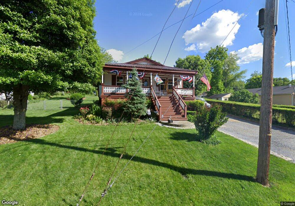
1836 Bay St Unit 1 Bristol, TN 37620
Estimated Value: $126,000 - $157,000
2
Beds
1
Bath
840
Sq Ft
$174/Sq Ft
Est. Value
About This Home
This home is located at 1836 Bay St Unit 1, Bristol, TN 37620 and is currently estimated at $146,280, approximately $174 per square foot. 1836 Bay St Unit 1 is a home located in Sullivan County with nearby schools including Anderson Elementary School, Vance Middle School, and Tennessee High School.
Ownership History
Date
Name
Owned For
Owner Type
Purchase Details
Closed on
Jul 10, 2008
Sold by
Benny Leonard
Bought by
Busby William D
Current Estimated Value
Home Financials for this Owner
Home Financials are based on the most recent Mortgage that was taken out on this home.
Original Mortgage
$56,119
Outstanding Balance
$36,569
Interest Rate
6.27%
Estimated Equity
$109,711
Purchase Details
Closed on
Mar 20, 2008
Sold by
Green Tree Servicing Llc
Bought by
Benny Leonard
Purchase Details
Closed on
Nov 2, 2007
Create a Home Valuation Report for This Property
The Home Valuation Report is an in-depth analysis detailing your home's value as well as a comparison with similar homes in the area
Home Values in the Area
Average Home Value in this Area
Purchase History
| Date | Buyer | Sale Price | Title Company |
|---|---|---|---|
| Busby William D | $57,000 | -- | |
| Benny Leonard | $24,000 | -- | |
| -- | $44,100 | -- |
Source: Public Records
Mortgage History
| Date | Status | Borrower | Loan Amount |
|---|---|---|---|
| Open | -- | $56,119 |
Source: Public Records
Tax History Compared to Growth
Tax History
| Year | Tax Paid | Tax Assessment Tax Assessment Total Assessment is a certain percentage of the fair market value that is determined by local assessors to be the total taxable value of land and additions on the property. | Land | Improvement |
|---|---|---|---|---|
| 2024 | -- | $16,850 | $3,350 | $13,500 |
| 2023 | $740 | $16,850 | $3,350 | $13,500 |
| 2022 | $740 | $16,850 | $3,350 | $13,500 |
| 2021 | $740 | $16,850 | $3,350 | $13,500 |
| 2020 | $416 | $16,850 | $3,350 | $13,500 |
| 2019 | $766 | $16,200 | $3,350 | $12,850 |
| 2018 | $763 | $16,200 | $3,350 | $12,850 |
| 2017 | $763 | $16,200 | $3,350 | $12,850 |
| 2016 | $753 | $15,600 | $5,025 | $10,575 |
| 2014 | $711 | $15,609 | $0 | $0 |
Source: Public Records
Map
Nearby Homes
- 1614 Broad St
- 1443 Windsor Ave
- 2000 Euclid Ave
- 60 Peters St
- 000 Hemlock Dr
- 1224 Shelby St
- 1227 Shelby St
- 1057 Moorland Ave
- 1724 & 1728 Euclid Ave
- 311 12th St
- 2177 Randolph St
- 2121 2123 Randolph St
- 1216 Norway St
- 420 Douglas St
- 461 Douglas St
- 728 Randolph St
- 2412,14,16 Bradley St
- 2241 Bradley St
- 2400 Bradley St
- 460 Vance St