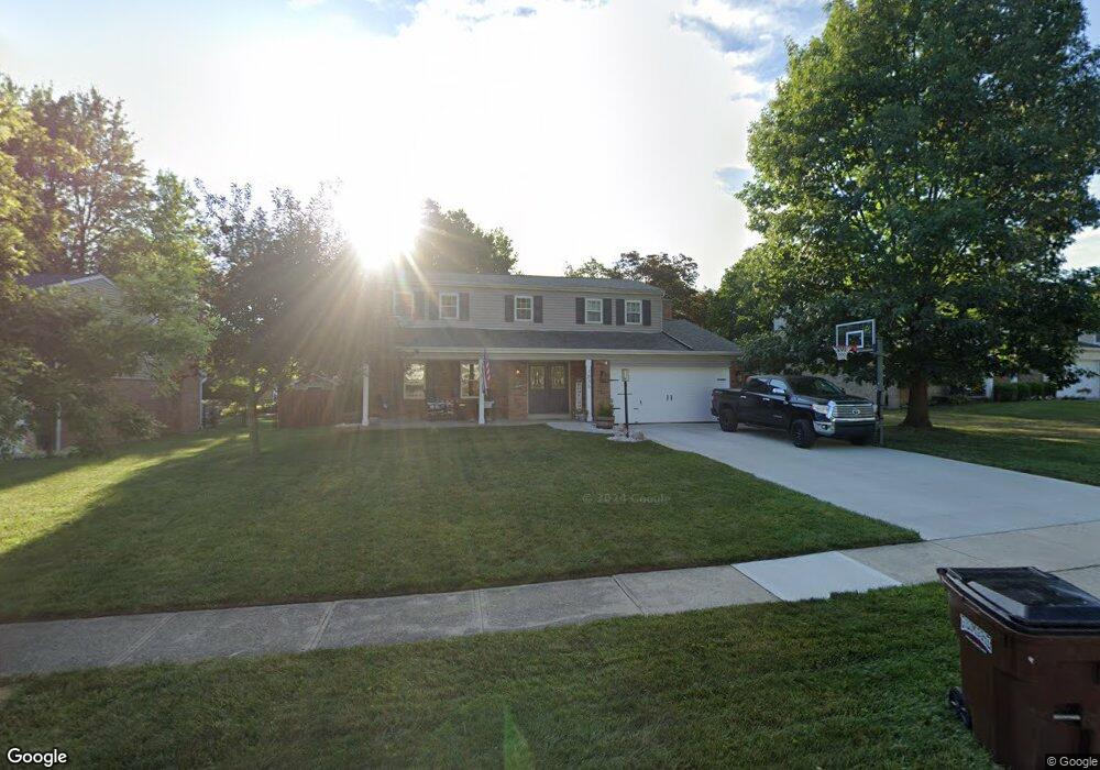
1836 Loisview Ln Cincinnati, OH 45255
Estimated Value: $356,310 - $407,000
4
Beds
3
Baths
2,035
Sq Ft
$189/Sq Ft
Est. Value
About This Home
This home is located at 1836 Loisview Ln, Cincinnati, OH 45255 and is currently estimated at $383,828, approximately $188 per square foot. 1836 Loisview Ln is a home located in Hamilton County with nearby schools including Summit Elementary School, Nagel Middle School, and Anderson High School.
Ownership History
Date
Name
Owned For
Owner Type
Purchase Details
Closed on
Sep 16, 2020
Sold by
Sorensen Andrew C and Sorensen Elizabeth L
Bought by
Hickey Michael C and Hickey Jenalee A
Current Estimated Value
Home Financials for this Owner
Home Financials are based on the most recent Mortgage that was taken out on this home.
Original Mortgage
$217,600
Outstanding Balance
$191,343
Interest Rate
2.9%
Mortgage Type
New Conventional
Estimated Equity
$192,485
Purchase Details
Closed on
Mar 31, 1994
Sold by
Kitzmiller David A and Kitzmiller Sharon M
Bought by
Sorensen Andrew C and Sorensen Elizabeth L
Home Financials for this Owner
Home Financials are based on the most recent Mortgage that was taken out on this home.
Original Mortgage
$118,598
Interest Rate
7.51%
Create a Home Valuation Report for This Property
The Home Valuation Report is an in-depth analysis detailing your home's value as well as a comparison with similar homes in the area
Home Values in the Area
Average Home Value in this Area
Purchase History
| Date | Buyer | Sale Price | Title Company |
|---|---|---|---|
| Hickey Michael C | $272,000 | Prodigy Title Agency | |
| Sorensen Andrew C | -- | -- |
Source: Public Records
Mortgage History
| Date | Status | Borrower | Loan Amount |
|---|---|---|---|
| Open | Hickey Michael C | $217,600 | |
| Previous Owner | Sorensen Andrew C | $118,598 |
Source: Public Records
Tax History
| Year | Tax Paid | Tax Assessment Tax Assessment Total Assessment is a certain percentage of the fair market value that is determined by local assessors to be the total taxable value of land and additions on the property. | Land | Improvement |
|---|---|---|---|---|
| 2025 | $5,957 | $95,200 | $17,605 | $77,595 |
| 2024 | $5,790 | $95,200 | $17,605 | $77,595 |
| 2023 | $5,507 | $95,200 | $17,605 | $77,595 |
| 2022 | $4,795 | $73,798 | $15,302 | $58,496 |
| 2021 | $4,682 | $73,798 | $15,302 | $58,496 |
| 2020 | $4,735 | $73,798 | $15,302 | $58,496 |
| 2019 | $4,616 | $65,307 | $13,542 | $51,765 |
| 2018 | $4,324 | $65,307 | $13,542 | $51,765 |
| 2017 | $4,079 | $65,307 | $13,542 | $51,765 |
| 2016 | $3,916 | $61,271 | $13,272 | $47,999 |
| 2015 | $3,803 | $61,271 | $13,272 | $47,999 |
| 2014 | $3,806 | $61,271 | $13,272 | $47,999 |
| 2013 | $3,672 | $62,521 | $13,542 | $48,979 |
Source: Public Records
Map
Nearby Homes
- 2015 Tall Pines Ln
- 1676 Laval Dr
- 1747 Summithills Dr
- 1748 Hilltree Dr
- 1662 Hilltree Dr
- 1847 Eight Mile Rd
- 0 Clough Pike Unit 1861584
- 8602 Linderwood Ln
- 4133 Brandonmore Dr
- 4383 Wiborg Dr
- 1885 Wanninger Ln
- 8146 Clough Pike
- 8320 Katies Ct
- 4077 Mclean Dr
- 7660 Clough Pike
- 7652 Clough Pike
- 2528 Teuton Ct
- 1333 Eight Mile Rd
- 8175 Timbercreek Dr
- 2256 Endovalley Dr
- 1844 Loisview Ln
- 1828 Loisview Ln
- 1852 Loisview Ln
- 1829 Loisdale Ct
- 1820 Loisview Ln
- 1823 Loisdale Ct
- 1835 Loisdale Ct
- 1837 Loisview Ln
- 1843 Loisview Ln
- 1817 Loisdale Ct
- 1831 Loisview Ln
- 1860 Loisview Ln
- 1812 Loisview Ln
- 1851 Loisview Ln
- 1823 Loisview Ln
- 1811 Loisdale Ct
- 1817 Loisview Ln
- 1842 Loisdale Ct
- 1859 Loisview Ln
- 8622 Denallen Dr
Your Personal Tour Guide
Ask me questions while you tour the home.