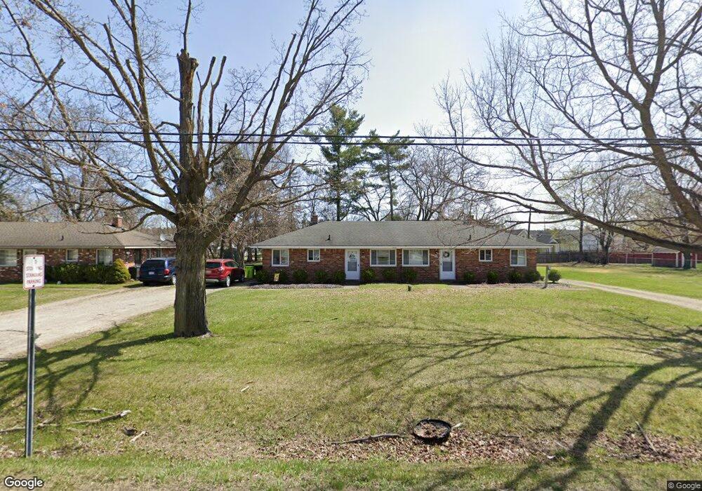
184 N John St Highland, MI 48357
Estimated Value: $249,000 - $329,000
2
Beds
1
Bath
900
Sq Ft
$319/Sq Ft
Est. Value
About This Home
This home is located at 184 N John St, Highland, MI 48357 and is currently estimated at $286,880, approximately $318 per square foot. 184 N John St is a home located in Oakland County with nearby schools including Highland Elementary School, Muir Middle School, and Christ Lutheran Christian Day School.
Ownership History
Date
Name
Owned For
Owner Type
Purchase Details
Closed on
May 9, 2023
Sold by
Dickinson Stephen
Bought by
206 John Street Llc
Current Estimated Value
Purchase Details
Closed on
Jun 29, 2018
Sold by
Smith Allan R
Bought by
Dickinson Stephen
Home Financials for this Owner
Home Financials are based on the most recent Mortgage that was taken out on this home.
Original Mortgage
$120,000
Interest Rate
4.5%
Mortgage Type
New Conventional
Purchase Details
Closed on
Jun 25, 1985
Sold by
Smith Asa R
Bought by
Smith Alan R
Create a Home Valuation Report for This Property
The Home Valuation Report is an in-depth analysis detailing your home's value as well as a comparison with similar homes in the area
Home Values in the Area
Average Home Value in this Area
Purchase History
| Date | Buyer | Sale Price | Title Company |
|---|---|---|---|
| 206 John Street Llc | -- | None Listed On Document | |
| Dickinson Stephen | $160,000 | Fidelity National Title | |
| Smith Alan R | -- | -- |
Source: Public Records
Mortgage History
| Date | Status | Borrower | Loan Amount |
|---|---|---|---|
| Previous Owner | Dickinson Stephen | $120,000 |
Source: Public Records
Tax History Compared to Growth
Tax History
| Year | Tax Paid | Tax Assessment Tax Assessment Total Assessment is a certain percentage of the fair market value that is determined by local assessors to be the total taxable value of land and additions on the property. | Land | Improvement |
|---|---|---|---|---|
| 2024 | $4,549 | $112,380 | $0 | $0 |
| 2023 | $3,450 | $104,370 | $0 | $0 |
| 2022 | $4,392 | $93,630 | $0 | $0 |
| 2021 | $4,153 | $88,940 | $0 | $0 |
| 2020 | $3,107 | $79,630 | $0 | $0 |
| 2019 | $4,046 | $76,000 | $0 | $0 |
| 2017 | $3,497 | $75,650 | $0 | $0 |
| 2016 | $0 | $70,440 | $0 | $0 |
| 2015 | -- | $70,810 | $0 | $0 |
| 2014 | -- | $69,650 | $0 | $0 |
Source: Public Records
Map
Nearby Homes
- 265 E Livingston Rd
- 398 Delmar Ct
- 446 Delmar Ct
- 688 Perthshire Ct
- 489 Gleneagles
- 53 Ash Ave Unit 53
- 52 Ash Ave Unit 52
- 173 Birch Unit 173
- 1156 Alissa Marie Dr Unit 6
- 258 Spruce Unit 258
- 33 Pine Unit 33
- 5 Cedar Unit 5
- 288 Prestwick Trail
- 1420 Pettibone Lake Rd
- 1350 Pettibone Lake Rd
- 1298 E Highland Rd
- 431 Timber Ridge Dr Unit 10
- 1949 Percy
- 1900 Percy
- 1449 Gleneagles Unit 257
- 186 N John St
- 206 N John St
- 150 N John St
- 210 N John St
- 179 N Milford Rd
- 153 N Milford Rd Unit 103
- 153 N Milford Rd
- 222 N John St
- 211 N Milford Rd
- 161 N Milford Rd Unit 102
- 161 N Milford Rd
- 150 W Livingston Rd
- 147 N Milford Rd
- 141 N Milford Rd
- 134 W Livingston Rd
- 227 N Milford Rd
- 114 W Livingston Rd
- 170 N Milford Rd
- 0 Milford Rd Unit 4964705
- 0 Milford Rd Unit 4963057