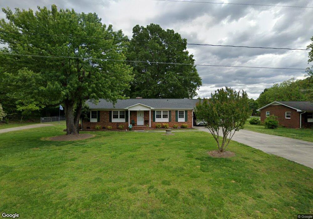
1841 Weant Rd High Point, NC 27263
Estimated Value: $244,000 - $377,000
3
Beds
2
Baths
1,595
Sq Ft
$180/Sq Ft
Est. Value
About This Home
This home is located at 1841 Weant Rd, High Point, NC 27263 and is currently estimated at $287,590, approximately $180 per square foot. 1841 Weant Rd is a home located in Guilford County with nearby schools including Allen Jay Elementary School, Southern Guilford Middle, and Southern Guilford High School.
Ownership History
Date
Name
Owned For
Owner Type
Purchase Details
Closed on
Aug 5, 2024
Sold by
Locklear Jack and Locklear Betty Sue
Bought by
Locklear Jack and Locklear Betty Sue
Current Estimated Value
Purchase Details
Closed on
Mar 30, 1999
Sold by
Estate Of Mozelle Royals Knox
Bought by
Locklear Jack and Locklear Betty Sue
Home Financials for this Owner
Home Financials are based on the most recent Mortgage that was taken out on this home.
Original Mortgage
$91,900
Interest Rate
6.82%
Mortgage Type
Purchase Money Mortgage
Create a Home Valuation Report for This Property
The Home Valuation Report is an in-depth analysis detailing your home's value as well as a comparison with similar homes in the area
Home Values in the Area
Average Home Value in this Area
Purchase History
| Date | Buyer | Sale Price | Title Company |
|---|---|---|---|
| Locklear Jack | -- | None Listed On Document | |
| Locklear Jack | $107,000 | -- |
Source: Public Records
Mortgage History
| Date | Status | Borrower | Loan Amount |
|---|---|---|---|
| Previous Owner | Locklear Jack | $91,900 |
Source: Public Records
Tax History
| Year | Tax Paid | Tax Assessment Tax Assessment Total Assessment is a certain percentage of the fair market value that is determined by local assessors to be the total taxable value of land and additions on the property. | Land | Improvement |
|---|---|---|---|---|
| 2025 | $1,319 | $150,400 | $25,000 | $125,400 |
| 2024 | $1,319 | $150,400 | $25,000 | $125,400 |
| 2023 | $1,319 | $150,400 | $25,000 | $125,400 |
| 2022 | $1,319 | $150,400 | $25,000 | $125,400 |
| 2021 | $1,041 | $118,700 | $20,000 | $98,700 |
| 2020 | $1,041 | $118,700 | $20,000 | $98,700 |
| 2019 | $1,041 | $118,700 | $0 | $0 |
| 2018 | $1,036 | $118,700 | $0 | $0 |
| 2017 | $1,004 | $118,700 | $0 | $0 |
| 2016 | $989 | $113,000 | $0 | $0 |
| 2015 | $994 | $113,000 | $0 | $0 |
| 2014 | $1,006 | $113,000 | $0 | $0 |
Source: Public Records
Map
Nearby Homes
- 105 Oak Ridge Dr
- 0 Waterbury Dr
- 3738 Amber Way
- 4375 Huff Rd
- 101 Brightleaf Ct
- 107 Autumn Hill Ct
- 510 Aldridge Rd
- 1650 Kersey Valley Rd
- 1638 Kersey Valley Rd
- 147 Dove Meadows Dr
- 6111 Appletree Ct
- 108 Sprucewood Ct
- 4020 Knollwood Dr
- 0 Sprucewood Ct
- 611 Liberty Rd
- 000 Liberty Rd
- 219 Tarheel Dr
- 126 Apollo Cir
- 4405 Knollwood Dr
- 118 Rand Blvd
- 6152 Weant Rd
- 1835 Weant Rd
- 3772 Chadwick Dr
- 3790 Chadwick Dr
- 7026 Weant Rd
- 1840 Weant Rd
- 7100 Chanterelle Dr
- 7102 Chanterelle Dr
- 1836 Weant Rd
- 7104 Chanterelle Dr
- 7004 Weant Rd
- 3755 Chadwick Dr
- 3751 Chadwick Dr
- 3741 Chadwick Dr
- 6505 & 6507 Staffordshire Dr
- 7224 Chanterelle Dr
- 6510 Staffordshire Dr
- 7203 Chanterelle Dr
- 7213 Chanterelle Dr
- 111 Oak Ridge Dr
Your Personal Tour Guide
Ask me questions while you tour the home.