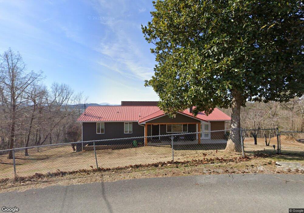
1845 Bouldercrest Dr Dandridge, TN 37725
Estimated Value: $464,000 - $584,163
3
Beds
2
Baths
1,545
Sq Ft
$342/Sq Ft
Est. Value
About This Home
This home is located at 1845 Bouldercrest Dr, Dandridge, TN 37725 and is currently estimated at $528,291, approximately $341 per square foot. 1845 Bouldercrest Dr is a home located in Jefferson County.
Ownership History
Date
Name
Owned For
Owner Type
Purchase Details
Closed on
Feb 19, 2021
Sold by
Walker Esther and Walker Kim
Bought by
Rediske Thomas Edward and Rediske Jill Marie
Current Estimated Value
Purchase Details
Closed on
Mar 22, 2006
Bought by
Walker Esther and Walker Kim
Home Financials for this Owner
Home Financials are based on the most recent Mortgage that was taken out on this home.
Original Mortgage
$299,250
Interest Rate
6.23%
Purchase Details
Closed on
Dec 13, 2005
Bought by
Hancock Sarah R and Hancock Esther Walker
Purchase Details
Closed on
Nov 7, 2005
Bought by
Hancock Sarah R and Hancock Esther Walker
Purchase Details
Closed on
Jun 16, 1999
Bought by
Hancock Sarah R
Purchase Details
Closed on
May 2, 1977
Bought by
Satterfield Satterfield J and Satterfield Grace
Purchase Details
Closed on
May 14, 1976
Create a Home Valuation Report for This Property
The Home Valuation Report is an in-depth analysis detailing your home's value as well as a comparison with similar homes in the area
Home Values in the Area
Average Home Value in this Area
Purchase History
| Date | Buyer | Sale Price | Title Company |
|---|---|---|---|
| Rediske Thomas Edward | $300,000 | Colonial Title Group Inc | |
| Walker Esther | -- | -- | |
| Hancock Sarah R | -- | -- | |
| Hancock Sarah R | -- | -- | |
| Hancock Sarah R | $162,000 | -- | |
| Satterfield Satterfield J | -- | -- | |
| -- | -- | -- |
Source: Public Records
Mortgage History
| Date | Status | Borrower | Loan Amount |
|---|---|---|---|
| Previous Owner | Not Available | $299,250 |
Source: Public Records
Tax History Compared to Growth
Tax History
| Year | Tax Paid | Tax Assessment Tax Assessment Total Assessment is a certain percentage of the fair market value that is determined by local assessors to be the total taxable value of land and additions on the property. | Land | Improvement |
|---|---|---|---|---|
| 2025 | $1,328 | $101,025 | $26,800 | $74,225 |
| 2023 | $1,328 | $57,750 | $0 | $0 |
| 2022 | $1,265 | $57,750 | $16,825 | $40,925 |
| 2021 | $1,265 | $57,750 | $16,825 | $40,925 |
| 2020 | $1,265 | $57,750 | $16,825 | $40,925 |
| 2019 | $1,265 | $57,750 | $16,825 | $40,925 |
| 2018 | $1,191 | $50,675 | $12,400 | $38,275 |
| 2017 | $1,191 | $50,675 | $12,400 | $38,275 |
| 2016 | $871 | $50,675 | $12,400 | $38,275 |
| 2015 | $871 | $37,075 | $5,500 | $31,575 |
| 2014 | $871 | $37,075 | $5,500 | $31,575 |
Source: Public Records
Map
Nearby Homes
- 1991 Lakebrook Cir
- 1928 Bouldercrest Dr
- 1988 Lakebrook Cir
- 136 Crosslake Ln
- 417 Little Cove Dr
- 1045 Southwind Cir
- 1806 Pheasant Crossing Dr
- 1018 Southwind Cir
- 1887 Lakebrook Cir
- 1710 Ferry Hill Rd
- 344 Economy Cir
- 1614 Sams Dr
- 1635 Sams Dr
- Lots 1&2 Ferry Hill Rd
- 312 Economy Cir
- 539 Morie Rd
- 1920 Mountain Lake Dr
- 428 River Bend Dr
- 323 Eagle Claw Ln
- 450 Riverbend Dr
- 1833 Bouldercrest Dr
- 1842 Bouldercrest Dr
- 1836 Bouldercrest Dr
- 1847 Bouldercrest Dr
- 1847 Bouldercrest Dr
- 757 Bouldercrest Dr
- 1819 Overlook Dr
- 1816 Bouldercrest Dr
- 725 Waters Edge
- 0 Waters Edge Lot #6 Unit 922232
- 1859 Bouldercrest Dr
- 1825 Bouldercrest Dr
- 720 Water's Edge
- 720 Waters Edge
- Lot 27 Bouldercrest Dr
- 721 Waters Edge
- 0 Bouldercrest Rd
- Lot 20 Bouldercrest Dr
- Lot #6 Waters Edge
- 708 Waters Edge Unit 28