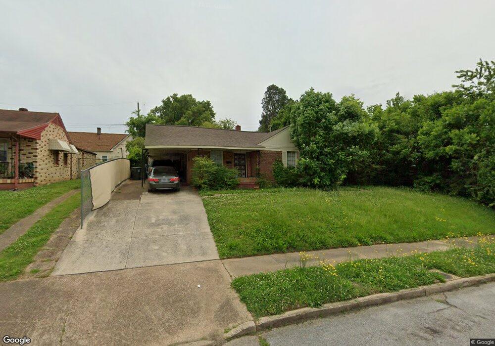
1847 Hearst Ave Memphis, TN 38114
Southeast Memphis NeighborhoodEstimated Value: $59,000 - $89,000
3
Beds
1
Bath
1,165
Sq Ft
$66/Sq Ft
Est. Value
About This Home
This home is located at 1847 Hearst Ave, Memphis, TN 38114 and is currently estimated at $76,644, approximately $65 per square foot. 1847 Hearst Ave is a home located in Shelby County with nearby schools including Hamilton High School, Memphis College Preparatory, and Veritas College Preparatory.
Ownership History
Date
Name
Owned For
Owner Type
Purchase Details
Closed on
May 5, 2016
Sold by
County Of Shelby
Bought by
Hoop 4 Life Llc
Current Estimated Value
Purchase Details
Closed on
Aug 31, 2006
Sold by
Owens Randy
Bought by
Owens Ernest M
Purchase Details
Closed on
Feb 14, 2005
Sold by
M Investment Co Inc
Bought by
Owens Randy
Purchase Details
Closed on
Feb 12, 2005
Sold by
Jackson Marquee and Jackson Adrianne
Bought by
M Investment Co Inc
Purchase Details
Closed on
Feb 11, 2005
Sold by
Gill Carolyn Barnes Jackson
Bought by
Jackson Marquee and Jackson Adrianne
Create a Home Valuation Report for This Property
The Home Valuation Report is an in-depth analysis detailing your home's value as well as a comparison with similar homes in the area
Home Values in the Area
Average Home Value in this Area
Purchase History
| Date | Buyer | Sale Price | Title Company |
|---|---|---|---|
| Hoop 4 Life Llc | -- | None Available | |
| Owens Ernest M | $28,500 | Realty Title & Escrow Co | |
| Owens Randy | $16,500 | -- | |
| M Investment Co Inc | -- | Stewart Title Co Of Memphis | |
| Jackson Marquee | -- | Stewart Title Co Of Memphis |
Source: Public Records
Tax History Compared to Growth
Tax History
| Year | Tax Paid | Tax Assessment Tax Assessment Total Assessment is a certain percentage of the fair market value that is determined by local assessors to be the total taxable value of land and additions on the property. | Land | Improvement |
|---|---|---|---|---|
| 2025 | $214 | $10,700 | $1,500 | $9,200 |
| 2024 | $214 | $6,325 | $1,000 | $5,325 |
| 2023 | $385 | $6,325 | $1,000 | $5,325 |
| 2022 | $385 | $6,325 | $1,000 | $5,325 |
| 2021 | $390 | $6,325 | $1,000 | $5,325 |
| 2020 | $402 | $5,550 | $1,000 | $4,550 |
| 2019 | $177 | $5,550 | $1,000 | $4,550 |
| 2018 | $177 | $5,550 | $1,000 | $4,550 |
| 2017 | $182 | $5,550 | $1,000 | $4,550 |
| 2016 | $290 | $6,625 | $0 | $0 |
| 2014 | $290 | $6,625 | $0 | $0 |
Source: Public Records
Map
Nearby Homes
- 1817 S Barksdale St
- 1936 Frisco Ave
- 1949 Lapaloma St
- 1971 Boyle Ave
- 1832 Rozelle St
- 1824 Rozelle St
- 996 Rozelle St
- 1698 Rayner St
- 1790 Westmore St
- 2151 Goff Ave
- 2149 Wabash Ave
- 1493 Oaklawn St
- 1721 W Silver St
- 1481 Oaklawn St
- 1911 Quinn Ave
- 1560 Cane Rd
- 1998 Cloverdale Dr
- 1816 Kerr Ave
- 0 Dublin Ave Unit LOTS 20 & 21 LAST TW
- 0 Airways Blvd Unit 10199303
- 1857 Hearst Ave
- 1839 Hearst Ave
- 1806 Hays Rd
- 1850 Ferber Ave
- 1858 Ferber Ave
- 1840 Ferber Ave
- 1850 Hearst Ave
- 1844 Hearst Ave
- 1793 State St
- 1797 State St
- 1856 Hearst Ave
- 1840 Hearst Ave
- 1801 State St
- 1807 State St
- 1864 Hearst Ave
- 1851 Carver Ave
- 1870 Hearst Ave
- 1868 Ferber Ave
- 1849 Ferber Ave
- 1847 Carver Ave