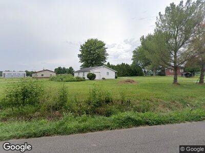
1848 E Main St Westport, IN 47283
Estimated Value: $247,000 - $301,246
3
Beds
3
Baths
1,440
Sq Ft
$188/Sq Ft
Est. Value
About This Home
This home is located at 1848 E Main St, Westport, IN 47283 and is currently estimated at $270,562, approximately $187 per square foot. 1848 E Main St is a home located in Decatur County with nearby schools including South Decatur Elementary School and South Decatur Junior/Senior High School.
Ownership History
Date
Name
Owned For
Owner Type
Purchase Details
Closed on
Aug 10, 2019
Sold by
Crussel Marvin L
Bought by
Crussel Marvin L and Crussel Carolyn M
Current Estimated Value
Purchase Details
Closed on
Oct 10, 2013
Sold by
Crussel Carolyn M
Bought by
Crussel Marvin Lynn
Home Financials for this Owner
Home Financials are based on the most recent Mortgage that was taken out on this home.
Original Mortgage
$113,500
Interest Rate
4.59%
Mortgage Type
Stand Alone First
Create a Home Valuation Report for This Property
The Home Valuation Report is an in-depth analysis detailing your home's value as well as a comparison with similar homes in the area
Home Values in the Area
Average Home Value in this Area
Purchase History
| Date | Buyer | Sale Price | Title Company |
|---|---|---|---|
| Crussel Marvin L | -- | -- | |
| Crussel Marvin Lynn | -- | -- |
Source: Public Records
Mortgage History
| Date | Status | Borrower | Loan Amount |
|---|---|---|---|
| Previous Owner | Crussel Marvin Lynn | $10,500 | |
| Previous Owner | Crussel Marvin Lynn | $113,500 | |
| Previous Owner | Crussel Marvin Lynn | $113,900 |
Source: Public Records
Tax History Compared to Growth
Tax History
| Year | Tax Paid | Tax Assessment Tax Assessment Total Assessment is a certain percentage of the fair market value that is determined by local assessors to be the total taxable value of land and additions on the property. | Land | Improvement |
|---|---|---|---|---|
| 2024 | $2,253 | $251,400 | $23,600 | $227,800 |
| 2023 | $1,517 | $234,500 | $23,600 | $210,900 |
| 2022 | $1,556 | $229,300 | $23,600 | $205,700 |
| 2021 | $1,617 | $193,600 | $23,600 | $170,000 |
| 2020 | $1,221 | $168,600 | $22,300 | $146,300 |
| 2019 | $1,080 | $152,800 | $22,300 | $130,500 |
| 2018 | $934 | $152,800 | $22,300 | $130,500 |
| 2017 | $890 | $154,500 | $22,300 | $132,200 |
| 2016 | $864 | $153,100 | $20,500 | $132,600 |
| 2014 | $830 | $146,500 | $20,500 | $126,000 |
| 2013 | $826 | $136,300 | $20,500 | $115,800 |
Source: Public Records
Map
Nearby Homes
- 357 S Water Plant Rd
- 606 E Gatewood Dr
- 604 N Allen Ln
- 217 E Sycamore St
- 512 Deer Run
- 303 N Range St
- 431 W Washington St
- 8733 S County Road 350 W
- 10275 N County Road 600 E
- 12554 S State Road 3
- 12544 S State Road 3
- 6736 S County Road 220 SW
- 6255 E County Road 850 N
- 6235 E County Road 850 N
- 28 W Co Road 700 S
- 00 W 1000 N
- 8675 N State Highway 3
- 5316 S County Road 60 SW
- 12001 S Co Road 1050 W
- 5306 S County Road 695 W
- 1848 E Main St
- 1848 E Main St
- 433 S Water Plant Rd
- 6390 E County Road 1150 N
- 413 S Water Plant Rd
- 801 S Water Plant Rd
- 379 S Water Plant Rd
- 1677 E Main St
- 1624 E Main St
- 899 S Water Plant Rd
- 309 S Water Plant Rd
- 1597 E Main St
- 271 S Water Plant Rd
- 1483 E Main St
- 265 S Water Plant Rd
- S Water Plant Rd
- 3852 W County Road 1100 S
- 3852 W County Road 1100 S
- 3877 W County Road 1100 S
- 3786 W Laytons Dr